| Navigation | |
An approach to e-Navigation
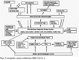
Analysis of the Issues Involved * accurate, comprehensive and regularly up-to-dated Electronic Navigational Charts (ENCs), covering the entire geographical area of a vessel’s operation; Issues to be ConsideredContemporary technologies already provide the capability to deliver much of the envisaged E-Navigation strategy. The co-sponsors of this document propose that the MSC, and its subsidiary bodies, should focus on creating the right environment to realize the full potential of these navigational technologies. This new work programme item will also need to tackle a wide range of issues (extending beyond what is already being done at IMO), including: 1. increasing the production, coverage and interfaces of ENCs; as well as accelerating the distribution and promotion of commercially viable and globally accepted protocols for ENC production and updating; Do the Benefi ts Justify This Proposed Action?Considerable sums of money are expended by shipowners and operators, on top of the substantial resources deployed by fl ag, port and coastal State regulators, in seeking to make marine navigation easier and to reduce navigational errors and failures. The E-Navigation strategy would enable the industry to benefi t from reducing these costs in the long-term. The cosponsors of this submission are convinced that if action is not taken soon, the disadvantages of pursuing uncoordinated individual technologies will outweigh the potential benefi ts that together they could deliver. Focusing resources on the co-ordination of improvements to navigational and communication tools will bring substantial overall safety, security, environmental protection and commercial benefits. Full analysis of costs will be needed, if and where these occur over and above those that have already been considered by IMO for the range of existing required navigational and communication systems. The co-sponsors recognize that any such new costs may include those related to the administrative burden on contracting States as a consequence of any changes to current national regulations that may be necessary. Coastal and port States incur substantial expenditure in providing physical aids to navigation, whether funded by the public purse or met by the shipowner through dues levied on port traffi c. Although a great deal has been done by coastal and port States in reducing such costs – by automation, by the application of lowmaintenance equipment and by the use of renewable energy sources – there will be continued upwards pressure on the cost of servicing aids to navigation networks, given the dependence on skilled labour and fuel. For developing countries especially, the establishment costs for physical aids to navigation or the costs to affect a transfer to the use of renewable energy sources or increased automation can be considerable. A comprehensive and integrated E-Navigation strategy would provide the opportunity for reducing overall costs whilst fully meeting obligations for the safety of navigation. The Core Objectives Of An Integrated E-navigation SystemUsing electronic data capture, communication, manipulation and display, to [NAV 53/13/., 2007]: Using electronic data capture, communication, processing and presentation, to: 1. facilitate safe and secure navigation of vessels having regard to hydrographic and navigational information and risks (e.g. coastline, seabed topography, fi xed and fl oating structures, meteorological conditions and vessel movements). ConclusionsThe co-sponsors of this submission believe that the time is right to develop a coherent E-Navigation policy to embrace the ever-growing and complex set of technological aids which already exist. Delivery of this vision requires a clear, global commitment, articulated through a viable and coherent framework which sets out a migration plan (from where we are to where we want to go) for Governments and industry to achieve a common and consistent format for the use of electronic technologies. The challenge for IMO is to develop a framework which accommodates and builds on existing systems already furthering the concept of E-Navigation, such as the World Bank-funded Marine Electronic Highway project in the Malacca Straits and the European Union’s projects ATOMOS IV (Advanced Technology to Optimize Maritime Operational Safety – Intelligent Vessel) and MarNIS (Maritime Navigation and Information Services). The framework must deliver improved navigational safety for maritime Authorities, coastal States and the master of a vessel, without imposing unnecessary burdens on them. ReferencesBasker, S. 2005. E-Navigation: The way ahead for the maritime sector. IMO MSC 81/23/10, 2005. Work Programme. Development of an e- Navigation strategy. Submitted by Japan, Marshall Islands, the Netherlands, Norway, Singapore, the United Kingdom and the United States, International Maritime Organization, London, 19 December IMO NAV 52/17/4, 2006. Any other business. An approach to E-Navigation, submitted by Japan. Sub-Committee on Safety of Navigation, International Maritime Organization, London, 12 May. IMO NAV 53/13/., 2007. Development of an E-Navigation Strategy. Report of the Correspondence Group on enavigation. Submitted by the United Kingom. International Maritime Organization, London, 20 April. Mitropoulos, E. 2007. E-navigation: a global resource. Seaways, The International Journal of the Nautical Institute, March. Patraiko, D. 2007. Introducing the e-navigation revolution. Seaways, The International Journal of the Nautical Institute, March. Specht, C. 2003. Availability, Reliability and Continuity Model of Differential GPS Transmission, Annual of Navigation No 5. Weintrit, A. 2006. Navitronics and Nautomatics – New Challenges for Navigation27. . Proceedings (Vol.1) of IAIN/GNSS 2006, 12th International Association of Institutes of Navigation (IAIN) World Congress “Navigation in IT Era”, and 2006 International Symposium on GPS/ GNSS, organised by Korean Institute of Navigation, ICC Jeju, Jeju, Korea. Weintrit, A. & Wawruch, R. 2006. Future of Maritime Navigation, ENavigation Concept. Proceedings of 10th International Conference “Computer Systems Aided Science, Industry and Transport” TRANSCOMP’2006, Zakopane, Poland, 4-7 December. |
|||||||||||||||||||||||||||||||||||||||||||
|
|||||||||||||||||||||||||||||||||||||||||||
|


 (No Ratings Yet)


