| Conference | |
Satellite Navigation turns the world into a global village
This year’s Munich Satellite Navigation Summit was held on March 1 – 3, 2016 under the motto: “GNSS – Creating a global village”. About 80 speakers from government, industry and science were invited by the organizing Institute of Space Technology and Space Applications (ISTA) of the Universitaet der Bundeswehr Muenchen to talk about the impact of satellite navigation on global developments and different areas of life.
GNSS connects the world
The 13th edition of the annual conference was kicked off on March 1 in the historical Court Church of All Saints with a ceremonial opening and discussions amongst high-level representatives from various European ministries and entities as well as from the USA and China. About 350 participants from 22 nations were welcomed by the Deputy Bavarian Minister-President and Bavarian State Minister for Economic Affairs and the Media, Energy and Technology, Ilse Aigner, as well as the Parliamentary State Secretary at the German Federal Ministry of Transport and Digital Infrastructure, Dorothee Bär, and Prof. Dr. Bernd Eissfeller, chairman of the conference. Ilse Aigner underlined that the aviation and space industry is a key sector in Bavaria. According to Ilse Aigner the dynamic of the new developments and the value added chain is perfectly used in the State of Bavaria, where 150 companies produce a sales volume of 350 Million and 90 more business start-ups are expected for the upcoming years.
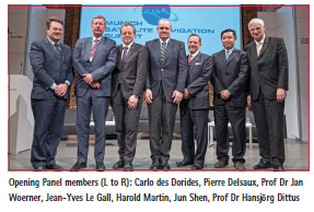
The topic of the panel discussion was “GNSS – An element of a global digital infrastructure”. It became clear that GNSS is a perfect tool to build up a global digital infrastructure. Pierre Delsaux, Deputy Director General, DG Internal Market, Industry, Entrepreneurship and SMEs at the European Commission, pointed out that EGNOS is already working very well and that it could be very useful for countries in the Southern Hemisphere, where negotiations with Africa are ongoing. Jean-Yves Le Gall, President of CNES, underlined that CNES fully supports the activities of the European Commission and that GNSS can help countries like Africa to skip one step in their development. Prof. Dr. Jan Woerner, Director General at ESA, highlighted that space activities are able to bridge the strongest problems on earth. The planned “moon village” will enable sustainable operations on the surface of the moon and shall open the exploration area for all states on the globe, in order to create a better world. Harold Martin, Director of the National Coordination Office for Space-Based Positioning, Navigation, and Timing in Washington, said that due to all the excellent systems the availability of information is at its best level and that impoverished nations can “cheaply take advantage of billions of dollars of investment by Northern Hemisphere countries”, for example by using a Smartphone.
The conference program continued on the following two days with a broad overview on different up-to-date topics and applications as well as several user segments. While the focus was on the regions and countries of the main service providers in the last years, it was the aim of this year to include the view of countries from the Southern Hemisphere like Africa, South America and South East Asia.
Besides the traditional first session on the global satellite navigation systems, the panel on regional and augmentation satellite navigation systems included for the first time representatives from the Southern Hemisphere. Julien Lapie from the Agency for Air Navigation Safety in Africa and Madagascar (ASECNA) informed about the development of a programme for the deployment of EGNOS in Africa. Dr. John A. Momoh from the Nigerian National Space Research and Development Agency described the test results for the satellite NigComSat-IR, which is fully operational. According to Dr. Momoh it showed a signal in space that is compatible with GNSS and could be the main part of an African SBAS. The panel discussion “GNSS in the Southern Hemisphere and Equatorial Regions”, chaired by Prof. Vidal Ashkenazi from Nottingham Scientific Ltd, focused on the perspective of countries like Australia, Brasil, Egypt, Japan and South Africa on current and future applications in Satellite Navigation. In the further course of the program topics like the Galileo PRS, the role of GNSS in Telematics Systems for the Autonomous Vehicle, the GNSS Authentication Services as well as Precise Positioning Technology in Agriculture and Forestry were discussed. The conference program was completed by an exhibition, at which several companies and institutions presented their business and products.
– Kristina Kudlich, kristina.kudlich@munich-satellite-navigation-summit.org


 (No Ratings Yet)


Leave your response!