| Mapping | |
Cartography as a tool in study of dredging
|
|||||||||||||||
|
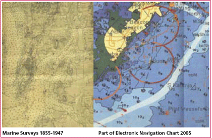
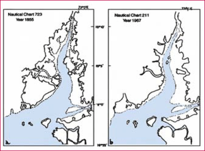
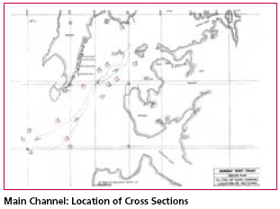
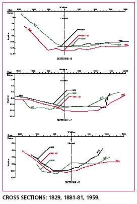
Mumbai acquired its port importance only with the advent of the Portuguese in 1508. Francis Almeida sailed into this harbour and called it as Bom Bahia or the Good Bay. The British corrupted the Portuguese name “Bom Baia” to “Bombay”. The Kolis used to call the islands “Mumba” after Mumbadevi. It was the British who developed it into a centre of commerce to rival any other centres in the country then. The British embarked upon large-scale reclamations and engineering works to consolidate the seven islands. In 1803 Bombay was connected with Salsette by a causeway at Sion. A causeway now called Colaba Causeway joined the island of Colaba to Bombay in 1838 and the Causeway connecting Mahim and Bandra was completed in 1845. This gave access to the rich hinterland of the Deccan providing further impetus for the growth of then Bombay. The Mumbai port was expanding and the need for extended port facilities led to formation of the Mumbai Port Trust (MPT) created in 1873.The MPT was responsible for reclamations and constructions in the harbour area of Mumbai. Sassoon docks were commissioned in 1875. In 1880 the Trust inaugurated the Princes’ Docks along with warehouses and storage sheds; in 1888 it completed the Victoria Docks, and two years later the Merewether Dry Docks. Towards the beginning of the 20th century, the MPT started on an immense project of reclamations all along the The problem faced by port activities in the Harbour Bay were mainly due to rapidly declining depths of the harbour making navigation difficult. This was further aggravated by the increasing traffic and that too with higher capacities. The harbour required greater depths up to 12 meters plus in the navigation channel. The existing channel prior to the construction was inadequate for accommodating the larger ships. The HarbourThe deep and safe Mumbai harbour is a creation of three main factors, The Thane creek, which branches from the west flowing Ulhas creek southwards off Thane along the eastern shores of salsette Island towards the Harbour Bay, acting more like a flush. On the eastern side of the harbour entrance lays the Dharamtar creek of the river Amba and Panvel and Patalganga creek joins the harbour east of Trombay and north of Nhava- Sheva. The port hardly had any problems of siltation till late fifties. Before reclamation the harbour depth was maintained due to natural topography, which allowed free access to the sea at various points. Excess silt was carried away to the sea. The story of dredging is best understood by a sequential study of maps over the last two to three centuries accompanied by cross sectional profiles. Cartography indeed becomes a powerful tool in understanding the problems and the temporal changes and shifts. Any solution for the future will have to be examined from a naval engineering point of view with the aid of maps of underwater soundings depths and the alignment of navigation channels. The present paper looks into this aspect, with help of maps and charts. The ProblemThe growing importance of the city as an economic hub resulted in increase in port activities. The Harbour Bay, which was initially a mud basin with multiple entries of the tidal rush through inland lagoons between the islands gradually, underwent transformation. Bombay became a major international harbour with the advent of steam navigation in the early 19th century followed by construction of docks in the second half. Technologically steam ships brought in a new era of larger vessels with a carrying capacity exceeding 50,000 tonnes and later reaching to 3 to 4 lakh tonnes. This required deeper drafts than that prevailing in the mid 19th century. The Harbour Bay was a small cove to south of the Castle where Bombay docks were built in 1848. Later the construction of docks along the eastern front consolidated the island city. The inflow of the tide from the west was totally blocked. The Harbour Bay became much wider and enlarged between the island city and the mainland shores. The inflow of rainwater floods in the Harbour Bay was both from north through the Thane creek and from the east through the large number of tidal inlets. The centripetal drainage of Dharamtar creek and Kundalika estuary further south, unfortunately, brought increasingly muddy and silty waters into the Harbour Bay making the bay shallower. Therefore in-spite of an enlarged bay it was subject to a rapid rate of siltation and sedimentation. The Thane creek ever since the railways were built in 60’s of 19th century was slowly silting since the Ulhas floods were blocked at silte depth level by railway and road bridges. During the 20th century the creek was subject to rapid decay both in width and depth. Thanks to land reclamations particularly along the eastern seaboard prominently in the second half of the twentieth century began to push into the Thane creek was progressively narrowing down the creek. Destruction of extensive mangroves on both sides of the creek added to the problems. These changes in the morphology of Thane creek are evident from the two nautical charts that of 1855 and 1967. Further the rise of New Bombay along with its residential and industrial areas along the Trans Thane creek and largescale reclamations along Mulund, Bhandup, Vikhroli and Ghatkopar, caused further destruction, Caught in this dual sided onslaught the creek is dying rapidly. The growth pattern suggests the lack of vision of town planners and builders regarding its impacts on the creek and the sea. The changes in the tidal flows, siltation and currents were ignored. Reclamations for making of Sion causeway and later along Sewree, Wadala stretch, and then recently the express way led to destruction of extensive mangrove forests along the creek further reducing the natural silt traps. The major impact of this has been that the natural flushing of the silt in the harbour is getting reduced thereby making the Harbour Bay shallower. The reclamations altered the flows and currents resulting in increased siltation drastically. Now the natural harbour needs to be continuously dredged. Presently some of the docks and breakwaters have been rendered difficult to access. Due to siltation a heavy price is paid for faulty designing and ignoring natural the forces of the sea.1 The creek decay has literally choked the north end of the Harbour Bay. All this meant that the Harbour Bay had to be dredged constantly so as to maintain a navigable channel with the entries to the docks at the desired depths. Lack of vision in construction of the docks opening to the north has contributed to the tidal flush hitting the mainland shore turning south in a ebb along the docks and contributing to siltation of docks themselves which acted as silt traps. While it was being realized that dredging was inevitable its intensity has however to be gauged and constantly monitored. The depth of the Harbour Bay even in middle stretches did not exceed 7 to 8 metres in earlier stages. 20th century Navigation demanded approach channels that are at least 12 metres plus deep to reach the individual docks. Dredging requirement in Mumbai harbour is steadily increasing and at present is about 10 million M3 per year2. The silt mainly accumulates around the corners and barriers. The main channel needs to be dredged deeper every fourth year as the Thane creek flushes the Harbour Bay. as seen earlier. With increasing congestion of traffic in the last 30 to 40 years in the Mumbai harbour the Centre took decision to develop an independent container port with its own infrastructure facilities. The obvious purpose was to segregate the port traffic of Mumbai docks from the container traffic now converging at the Nhava Sheva renamed JNPT or the Jawaharlal Nehru Port Trust. In retrospect it appears that the location of this container terminal port is possibly a two fold blunder for two reasons. Firstly international container vessels being much larger in size than the shipping vessels hitherto visiting Mumbai there is dire need for much greater draft depth of least 15 to 16 metres, since the navigation channel through which traffic flows from the Harbour Bay entrance to JNPT container port is merely an extension of already existing navigation channel leading to Mumbai docks. While apparently the pressure on docks traffic is reduced theoretically the impact on the navigation channel has tremendously enhanced and the congestion is nowhere showing symptoms of reduction. New problems are arising and dredging the channel to further depth of 5 metres is posing a tremendous challenge that may even boomerang. There is yet another problem that dredging creates, While dredging is becoming a necessity the removal and dumping of the dredged spoil is even more exacting. In earlier stages during the second half of the 20th century the spoil was being dumped in the Karanja- Uran base that has fast filled in. The nature of tidal circulation in Harbour Bay partly shifts the dumped material into the Mumbai docks that have got to be dredged continuously to the relevant depths. Also simultaneously a large volume of spoil is taken southwards by littoral drift circulation that in early days used to choke the Dharamtar creek, but now is being carried further south of Revas, Kihim, Chaul and Alibag shores incidentally resulting in formation of new beaches. Any further dredging as visualised to help the container port would demand a fresh dumping ground much further south along the Konkan coast or at greater depths either way posing serious navigation hazards. Already few vessels have wrecked on the approach to harbour due to siltation. A third aspect is that of Thane creek decay and any further siltation would lead to a direct impinging effect on the JNPT port to north of Elephanta. The dilemma for the port authorities is pretty serious. to dredge or not to dredge. Perhaps a better solution would be to take a bold decision to shift the container port to a much further destination. The political will required will demand an enlightened government. References1. Maintaining Underwater Topography in Bombay Harbour by Water Injection Dredging, Lt.Cdr R.S. Chakravorty, Proceedings of nineteenth anniversary joint seminar, Maritime History Society, March 1998. 2. Early European Nautical Charts of Mumbai Port and Harbour, Ms Laxmi Vyas, Proceedings of nineteenth anniversary joint seminar, Maritime History Society, March 1997. 3. Is Thane Creek Dying? Dr PP Gogte, B Arunachalam, Proceedings of nineteenth anniversary joint seminar, Maritime History Society, march 1998. 4. Some Suggestions for a wider use of Indian Nautical Charts, B. Arunachalam, Proceedings of nineteenth anniversary joint seminar, Maritime History Society, March 1998. 5. Mumbai By The Sea. B. Arunachalam, Maritime History Society, 2004. 6. Early Marine Charts of India. Dr. S.P.Sharma, National Hydrographic Office. 2004. 7. Bombay Port Trust Master Plan, Vol.2. Appendices, 1970. |
|||||||||||||||
|
|||||||||||||||
|


 (3 votes, average: 3.33 out of 5)


