NEWSBRIEFS – GPS
Jul 2006 | Comments Off on NEWSBRIEFS – GPS
|
|
|
|
|
|
| |
 |
|
|
IRNSS to be independent of other constellations
The Indian Space Research Organisation (ISRO) will be establishing a satellite navigation system on the lines of the US GPS. The proposed Indian Regional Navigation Satellite System (IRNSS), which will consist of a constellation of eight satellites, is likely to be operational in six years time.
The Union Cabinet had approved the Rs 1,600 crore project in May this year. According to Madhavan Nair, Chairman ISRO the IRNSS would be developed indigenously and will be independent of other constellations.
|
|
|
Cars to dominate mapping industry

Navigation in motor vehicles will be the most significant application of spatial technology by 2010, according to figures released at a conference in Taiwan. The market will reach around US$30 billion. By way of contrast, the annual Daratech survey of the spatial industry put the value of land information systems at only $8 billion last year. The best estimates of industry growth suggest this might rise to $10 billion by 2010. The information is contained in a report released at the Autotronics conference
and exhibition held in Taipei last month. The report says each will have around 20 per cent of the market.
|
|
|
|
GPS mapping to aid education scheme in India
Madurai district is one of the districts in Tamil Nadu, India, which is using GPS to map the schools and areas as a part of project called SCHOOLGIS, funded by Ministry of Human Resources through Sarva Siksha Abhiyan (Education for All) scheme, Government of Tamil Nadu, A Sundaram, Department of Future Studies, Madurai Kamaraj University and S Vasudevan, Department of Geology, Bharathidasan University.
By using the outcome of the present project, the user can find out the areas which remain inaccessible to primary schools within the user specified distance against the backdrop of the sufficient number of general population and also school-going population as per SSA indicators. www.newindpress.com
|
|
|
Satellite guidance for the visually impaired
A prototype satellite navigation system accurate enough to direct vision-impaired pedestrians to their destination has recently been successfully demonstrated in Madrid. Developed by ESA, with the Spanish firm GMV Sistemas, this device offers greater autonomy for the visually impaired. The system is not intended to replace a white cane or a guide dog but to complement them with an ‘audible map’. The user no longer needs to seek frequent guidance from other pedestrians; the guidance equipment follows his every move and advises him accordingly.
This system, designed with the advice of the Spanish National Organisation for the Blind (Organisacion Nacional de los Ciegos de España -ONCE), is based on EGNOS, a positioning system that processes GPS data to provide improved accuracy.
This is rather important for a blind person, since a one metre localisation accuracy makes the difference between being on the path or in the road. www.esa.int

|
|
|
GPS to aid in Tsunami Warnings
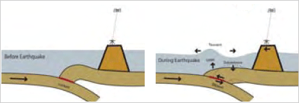
University scientists using Global Positioning System software, developed by NASA, have shown GPS can determine, within minutes, whether an earthquake is big enough to generate an ocean-wide tsunami. This NASAfunded technology can be used to provide faster tsunami warnings.
A team led by Geoffrey Blewitt of the Nevada Bureau of Mines and Geology and Seismological Laboratory, University of Nevada, Reno, demonstrated that a large quake’s true size can be determined within 15 minutes using GPS data. This is much faster than current methods. The new method, called GPS displacement, works by measuring the time radio signals from GPS satellites arrive at ground stations located within a few thousand kilometers of a quake. From these data, scientists can calculate how far the stations moved because of the quake. They can derive an earthquake model and the quake’s true size, called its ‘moment magnitude.’ This magnitude is directly related to a quake’s potential for generating tsunamis. www.nasa.gov/home

|
|
|
|
|


 (5.00 out of 5)


 (5.00 out of 5)


 (5.00 out of 5)


 (5.00 out of 5)