| Applications | |
Risk-informed spatial planning of Shimla region
A Geospatial assessment of urban expansion suitability using multi-criteria framework |
 |
|
Abstract
Rapid urbanization in fragile Himalayan ecosystems necessitates robust land-use planning that balances development needs with environmental conservation. This study utilizes a Multi-Criteria Decision Support (MCDS) system, implemented via the Weighted Linear Combination (WLC) method within the Google Earth Engine (GEE) cloud computing platform, to delineate and quantify optimal areas for urban expansion around the Shimla region, Himachal Pradesh, India. Five critical factors—Slope, Land Use/Land Cover (LULC), Aspect, Road Proximity, and Geology—were integrated after normalization, weighted based on the Analytical Hierarchy Process (AHP), and strictly constrained by exclusionary zones (including steep slopes (>45°), protected areas, and water body buffers). The analysis identifies distinct suitability zones (Low, Moderate, High), highlighting key areas for planned development and also estimates suitable areas around six proposed satellite towns nearby Shimla. The efficiency of GEE for handling multi-source, high-resolution datasets (NASADEM, ESRI LULC 10m) demonstrates a powerful, replicable, and cost-effective framework for sustainable planning in complex, mountainous environments, offering a critical tool for regional development authorities. However, it is emphasized that high-resolution LULC data, DEM datasets, and detailed geological information are essential to support any policy decision on identifying such zones.
1. Introduction
Global urban growth demands a critical shift from uncontrolled sprawl to sustainable, scientifically informed expansion. In challenging geographical areas, such as the Himalayan mountain range, this requirement is amplified due to inherent geo-environmental risks (landslides, seismic activity) and ecological fragility. As per the latest seismic zonation study of India, Himachal Pradesh falls largely within a very high seismic risk zone, indicating significant vulnerability to strong earthquakes. The Shimla region, a major administrative and tourist hub, faces severe pressure on its limited developable land, often leading to haphazard construction in unsafe and ecologically sensitive zones. This paper formalize this challenge by presenting a remote sensing-based geospatial modeling approach to map urban suitability. The chosen methodology integrates diverse physical factors using MCDS-WLC, offering an objective and quantitative basis for future land-use policy in the Shimla planning area.
2. Background
Shimla’s planning perspective is deeply rooted in its colonial-era origin, where the town evolved along ridges and spurs due to steep topography. Early development followed a linear ridge-based pattern, with British planners prioritizing administrative functions, pedestrian movement, and climate-responsive architecture. Over time, Shimla’s growth expanded increasingly into peripheral slopes, creating challenges related to infrastructure, land stability, and service delivery. Contemporary planning efforts now focus on sustainable hill-town development, resilience to seismic and slope hazards, and decongestion while preserving the unique heritage character of the city.
2.1 Rationale
Urban growth in the Himalayan region is driven by tourism, administrative concentration, and educational opportunities. However, conventional expansion patterns are unsustainable due to topographical limitations, geological fragility, and inadequate infrastructure resilience. Shimla, categorized under very high seismic risk zone making it particularly vulnerable to slope instability and seismic hazards.
The Town and Country Planning Department of Himachal Pradesh, under its Vision 2040 Framework, emphasizes geospatially guided land use decisions. The National Mission on Himalayan Studies (NMHS) and National Clean Air Programme (NCAP) also advocate geospatial tools for integrating environmental sustainability into urban planning.
In this policy environment, Geospatial Suitability Analysis (GSA) emerges as a scientific foundation for implementing controlled expansion, zoning regulation, and hazard-sensitive construction.
2.2 Objectives of the Study
1. To delineate spatially suitable areas for future urban development in the Shimla region using a multi criteria analytical framework.
2. To integrate geotechnical, ecological, and infrastructural factors through weighted modeling using Analytic Hierarchy Process (AHP)-derived weights.
3. To generate a high-resolution suitability map as a decision-support tool for planners and policymakers
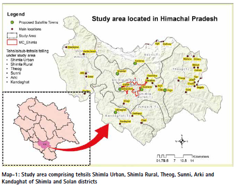
3. Study Area
The study area encompasses the Shimla planning region and its immediate periphery in Himachal Pradesh, India (approximate co-ordinates: 77.0°E to 77.3°E and 30.9°N to 31.3°N). This mountain region is characterized by rugged topography, steep slopes, and varied lithology belonging to the Lesser Himalayan tectonic belt.
3.1 Risk-Informed Urban Suitability Assessment for the Expansion
The Multi-Criteria Decision Support (MCDS) analysis using the Weighted Linear Combination (WLC) method serves as a proactive and strategic planning instrument tailored to the heightened vulnerability of the Shimla region. With increasing incidences of cloudbursts, erratic rainfall, landslides, and the region’s location within a high seismic zone, traditional urban expansion approaches have become inadequate. This study advances a risk-informed spatial planning framework that shifts the focus from mere land availability to long-term safety, geological stability, and environmental sustainability. It supports informed decision-making for future urban extensions, satellite towns, and counter magnet towns in and around Shimla.
3.1.1. Core Objective: Disaster Risk Reduction (DRR) and Geological Stability
The central purpose of this assessment is to minimize exposure to landslide- and earthquake-prone areas, which have caused extensive damage across Himachal Pradesh.
• Geological Suitability:
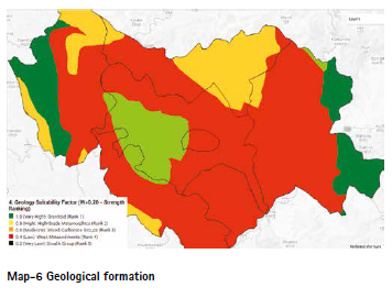
The model assigns substantive weight to geological conditions, ranking land parcels based on rock strength and structural stability. This directs development away from weak, fractured, or weathered formations (e.g., Siwalik Group) and toward more competent lithologies (e.g., Granitoids/High-Grade Metamorphics) capable of withstanding intense rainfall and seismic forces.
• Landslide Risk Mitigation:
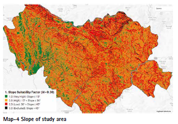
Recognizing slope as a primary driver, the model applies the highest weight to the slope factor and enforces a strict exclusion of areas with slopes >45°. This ensures that no infrastructure is placed in excessively steep or unstable zones, safeguarding human life and built assets.
3.1.2 Hydro-Climatic Resilience and Protection of Natural Water Systems
To respond to rising incidences of cloudbursts, flash floods, and extreme runoff events, which are now a day’s regular occurrences, the study strengthens the natural hydrological system through targeted constraints.
• Protection of Rivers and Water Bodies:
A 50-meter buffer around all lakes, reservoirs, and rivers prevents encroachment onto floodplains and riparian zones. This preserves the natural absorptive and dissipative capacity of these systems during extreme rainfall, thereby enhancing resilience for both new and downstream settlements. Recent years have seen a rise in building/infrastructure collapses along riverbanks, especially in Kullu, Manali, and Rampur, during periods of extreme rainfall.
• LULC-Based Environmental Safeguards:
Dense forest areas (LULC = 10) are excluded to protect natural interception and infiltration processes that regulate surface runoff, recharge groundwater, and reduce flood severity. It is important to emphasize that the forests of Himachal Pradesh play a crucial role in safeguarding the environment and maintaining the integrity of the ecosystem.
3.1.3 Ecological Safeguards and Environmental Integrity
Sustainable Himalayan development necessitates the protection of ecologically sensitive zones and natural habitats, particularly in regions like Shimla where fragile slopes, dense forests, and limited carrying capacity demand careful planning. The city’s unique topography, rich biodiversity, and dependence on natural drainage systems make the preservation of surrounding forested areas and ecological buffers essential for reducing disaster risks, maintaining water security, and ensuring long-term environmental stability.
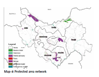
• Exclusion of Protected and Reserve Areas:
Wildlife sanctuaries, protected areas, and reserve forests are treated as strict “no development zones,” reinforced with a 10-meter protective buffer. This ensures urban growth is confined to ecologically permissible regions while fulfilling legal and biodiversity conservation mandates.
• Geomorphological and Geotechnical Prioritization:
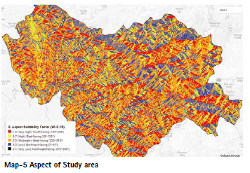
The integration of factors such as aspect (e.g., prioritizing sun-facing slopes for energy efficiency and improved snow clearance) alongside detailed geological parameters ensures that only well assessed, environmentally compatible sites are identified for development.
3.2 Socio-economic perspective: Decongesting Shimla
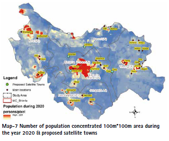
Shimla city has exceeded its carrying capacity due to tourism and administrative growth. The identification of suitable satellite towns and decentralised development is central to reducing environmental stress in the urban core. Keeping above in mind, consecutive State Governments proposed six potential satellite town locations namely Jathia Devi, Ghandal, Naldehra, Fagu, Kufri, and Shoghi. These are evaluated to provide policy-relevant recommendations for managed expansion.
4.1 Key Satellite Town Initiatives
1. Jathia Devi Township (near Shimla): The main objective to establish a planned, modern city (sometimes likened to a smaller version of Chandigarh) about 14 km from Shimla to alleviate pressure on the capital. The plan is to relocate various government offices, create planned housing societies, and provide comprehensive infrastructure like hospitals, schools, and commercial zones. It has been notified as a Planning Area and is currently in the development phase, with the government exploring funding through the Union Ministry of Housing and Urban Affairs and a Public Private Partnership (PPP) model.
2. The Shimla Development Plan (SDP) has also proposed the development of multiple other satellite towns/counter-magnet towns to decentralize development.
These proposed locations include:
▪ Ghandal
▪ Naldehra
▪ Fagu
▪ Chamiyana
▪ Vaknaghat (proposed as a “Cyber Cityˮ to attract IT-related activity).
4. Detailed Methodology
4.1 Theoretical Framework: MCDS and WLC
Multi-Criteria Decision Support (MCDS), particularly the Weighted Linear Combination (WLC) technique, is the standard methodology for continuous suitability mapping in Geographic Information Systems (GIS). WLC operates on the principle that the final suitability score (S) for a location is the weighted sum of normalized scores for each influencing factor (Fi), applied only to non-constrained areas.
Equation 1:
S = (Σ wi * Fi) * Π Cj
Where:
S: Final suitability score (0–1)
wi: Weight of factor i (Σ wi = 1)
Fi: Normalized factor score (0–1)
Cj: Binary constraint j (0 = excluded, 1 = allowed)
4.2 Role of Google Earth Engine (GEE)
Google Earth Engine (GEE) provides a cloud-native environment for processing petabytes of geospatial data. For this regional study, GEE permitted efficient handling of high-resolution DEMs and the ESRI Global LULC 10m product, reducing processing time and enabling reproducible workflows. Other open source GIS desktop application like QGIS has also been utilized.
5. Study Parameters and Their Role in Urban Suitability
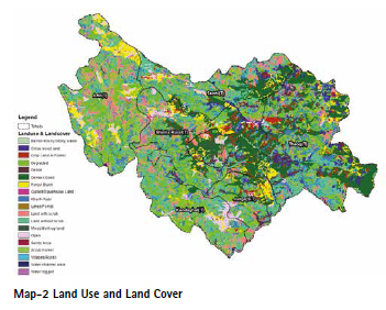
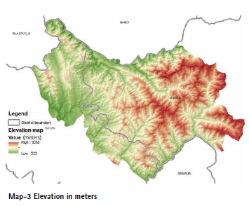
The study incorporates six distinct geospatial parameters to build a robust model for urban expansion suitability in the complex terrain near Shimla. These factors translate environmental and infrastructural realities into quantifiable scores. Elevation provides the fundamental topographic context, although its ruggedness is often captured by slope and aspect. Slope is the most critical factor, as it directly dictates geotechnical safety; areas with Slope} > 450 are strictly excluded (0.0), while flat land 150 receives the highest score (1.0). Aspect is incorporated for micro-climatic preference, quietly favouring sunny, south-facing slopes (1.0) over colder, north-facing slopes. The Geological Factor adds a layer of stability analysis by ranking rock groups based on their strength, giving strong formations high scores and weak groups low scores.
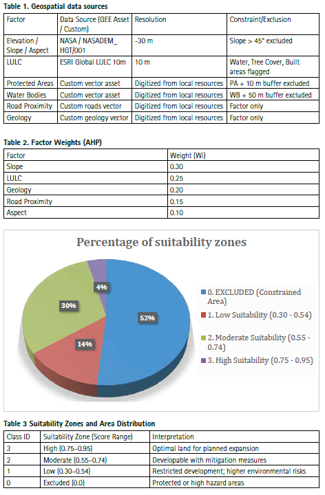
Environmental protection is ensured by designating sensitive land uses (like wildlife sanctuaries) and dense forest cover as strict exclusionary constraints 0.0 score. This policy is reinforced by the 0.0 score assigned to specific categories within LULC selection, prioritizing development on open or bare land (1.0). Distance from water bodies is also treated as a strict constraint by enforcing a buffer 50m where development is completely disallowed to protect riparian ecosystems and prevent flood/landslide risks. Finally, nearness to roads acts as a powerful accessibility driver, where land closest to existing infrastructure 500m receives the highest suitability scores, ensuring planned expansion is efficient and cost effective. These standardized scores, weighted by their importance (e.g., Slope: 0.30, LULC: 0.25), are combined via the WLC method to produce the final, objective suitability map.
6. Data Sources and Constraints
Data sources and constraints used in the analysis are summarized in table 1:
7. Factor Standardization (0–1 Score) and Justifications
Each non-constrained factor was standardized to a 0 to 1 suitability scale based on planning guidelines for mountainous areas. Slope received the highest weight due to safety considerations; LULC prioritized non-sensitive land; geology scored lithologies by stability; road proximity captured accessibility; aspect favored south-facing slopes for micro-climate advantages.
8. Weight Determination (AHP)
Weights were derived from a presumed AHP consultation reflecting priorities: slope (0.30), LULC (0.25), geology (0.20), road proximity (0.15), aspect (0.10). A pairwise comparison and consistency ratio check are recommended for participatory weighting in operational settings.
9. Suitability Calculation
The final suitability was computed using the WLC formula applied in GEE:
Suitability = (0.30 × F_slope) + (0.25 × F_LULC) + (0.20 × F_ geology) + (0.15 × F_roads) + (0.10 × F_aspect)
The resulting raster was then masked by the Final_ Constraints layer, so excluded areas receive a score of 0.
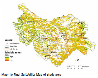
10. Results
The WLC model produced continuous suitability scores ranging from 0.30 (lowest non-excluded) to ~0.95 (highest). Areas with score 0 are excluded by constraints in table 3.
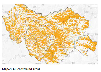
10.1 Constraint Analysis
Constrained zones are areas that are completely excluded from development or suitability analysis due to safety, environmental, or regulatory limitations. These zones typically include steep slopes, water bodies and their buffers, dense forests, wildlife sanctuaries, and other ecologically sensitive or hazard-prone regions. Any land falling under these categories is treated as a no-development area to prevent environmental damage, reduce disaster risk, and ensure sustainable planning. By identifying constrained zones early, planners can focus only on land that is truly safe and suitable for future growth.
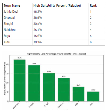
10.2 Satellite Town Suitability Assessment
High suitability percentage (Class 3: 0.75–0.95) within 10 km buffers around six towns: Map-9 All constraind areas Town Name Jathia Devi Ghandal Shoghi Naldehra Fagu Kufri High Suitability Percent (Relative) 45.2% 38.9% 30.5% 25.1% Rank 1 2 3 4 15.6% 10.3% 5 6 This ranking suggests that areas targeted for satellite town development, like Jathia Devi and Ghandal (which are in slightly gentler terrain often mentioned for expansion), possess a higher proportion of highly suitable land within their 10km buffer compared to areas like Kufri and Fagu, which are generally at higher altitudes with more environmental constraints (steeper slopes, protected areas, etc.)
11. Discussion and Conclusion
This study demonstrates that an MCDS-WLC framework implemented within GEE can efficiently produce high-resolution suitability maps for complex mountainous regions. The methodology supports planners by identifying safer, accessible, and less ecologically sensitive areas for satellite town development. However, integration of socio-economic datasets and participatory weighting would strengthen decision legitimacy.
6.1 Scope and Future Work
Future research should integrate socio-economic parameters such as utilities, land markets, and population distribution, along with dynamic climate vulnerability indicators. Validation using machine learning techniques, including Random Forests, would further strengthen the reliability of the analysis. However, it is emphasized that high-resolution LULC data, DEM datasets, and detailed geological information remain essential prerequisites for supporting any policy decisions related to the identification of such zones.
12. Policy Directions
The findings support evidence-based zoning and hazard-resilient urban planning aligned with Himachal Pradesh’s Vision 2040.
Future Enhancements: 1. Integrate landslide susceptibility and seismic risk layers. 2. Include socio-economic parameters like land cost and livelihood access. 3. Conduct structured AHP validation surveys. 4. Extend to temporal simulations for future land use projections.
12.1 Constraints of the Study
Key limitations include the static AHP weights (not participatory), generalized geology maps that may miss micro-scale hazards, and the potential for scale artifacts due to raster aggregation.
13. References
[1 Saaty, T. L. (1980). The Analytic Hierarchy Process. McGraw-Hill.
[2] Malczewski, J. (1999). GIS and Multicriteria Decision Analysis. John Wiley & Sons.
[3] Google Earth Engine Team. (2020). Google Earth Engine Public Data Catalog.
[4]Singh, R., et al. (202X). Assessment of urban vulnerability in Himalayan region using remote sensing and GIS. International Journal of Disaster Risk Reduction.
[5] ESRI. (2021). ESRI Global Land Cover 10m. Product Documentation.


 (1 votes, average: 5.00 out of 5)


Leave your response!