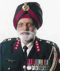
| His Coordinates, Interviews | |
“Security concerns about maps are at times overplayed”
|
||||
What are the activities of the Corps of Engineers?The Corps of Engineers is an arm of army that provides all the combat engineering support to the army. We are responsible for the construction and maintenance of the entire infrastructure that’s needed by the defence forces. It is our responsibility to facilitate the mobility of our forces whether it is on foot, on road or even by air especially in border areas. It is our job to provide infrastructure that helps our troops to fi ght the battle. In addition, we also erect obstacles in the path of enemy forces. How important are geospatial technologies in your activities?Mapping has its roots in military requirements. In fact, maps are the by-products of defence needs only. Geo-spatial technologies have a major role to play in this age of computerisation. We have military survey units to map border areas with the help of satellite imageries. More importantly, we need to have accurate maps (in paper/digital form) in order to plan for the defence of the country. What challenges do you face while introducing new technologies in your department?Whatever is needed in introducing the relevant technologies at our end, we do that. However, in government set up, it takes some time as certain procedures have to be followed. What is your opinion on the access of spatial information for developmental projects vis-à-vis security concerns?My own perception is that the security concerns are at times over played. Many countries do have the digital maps of their adversaries. In addition, one can get very sensitive information from many other sources. Google earth is one such example. It was not long ago when taking a photograph at airports was prohibited in India. Such rules are silly and ridiculous. As far as the debate goes, it will continue as there will always be security concerns which will need to be balanced with the need to make maps available to the private individuals/organizations for their use. How do you see the proposed introduction of open series maps for civilian use?It is a right step. For civilian purposes, one does not require highly accurate and detailed maps. The needs are different. Hence, enabling access to non-sensitive geo-spatial information for developmental projects and civilian purpose is a welcome step. The GPS system is under US control. Is it sensible to depend on this system?We must understand that nowadays weapons are very lethal and have potential to infl ict considerable damage. We have seen that in the recent Iraq war. It is essential to have a dependable guidance system to pin point the target and avoid collateral damage. Hence, it will be appropriate and important to explore the other options in this regard. If I go by the newspaper reports, I understand that the Government of India is evaluating and exploring other options also. How do you see the growth of geomatics in India?There is a vast difference in the way we used to map and the way we do it now. The growth in this technology is visible and perceptible. You can see this in the ongoing research in various academic institutes and the increasing demand for geo-spatial information for various projects. In addition, the growth of industry in this segment in recent years also reveals the potential in this fi eld. Awareness about such technologies is very high and that’s very good, as that ensures a promising future for these technologies.
|
||||


 (No Ratings Yet)


