| Mapping | |
Towards Spatially Enabled Societies and Governments
The future of spatial enablement and the realisation of a spatially enabled society, lie in it being a holistic endeavour where spatial (and land data) and non-spatial data are integrated according to evolving standards and with the SDI providing the enabling platform |
 |
|
 |
|
The rapid development and increased demand for spatial information infrastructures in many jurisdictions have made spatial information an invaluable tool in policy formulation and evidence-based decision making.
Spatial enablement, that is, the ability to add location to almost all existing information, unlocks the wealth of existing knowledge about social, economic and environmental matters, playing a vital role in understanding and addressing the many challenges we face in an increasingly complex and interconnected world. Spatial enablement requires information to be collected, updated, analysed, represented, and communicated, together with information on land ownership and custodianship, in a consistent manner to underpin good governance of land and its natural resources, whole-ofgovernment efficiency, public safety and security towards the well-being of societies, the environment and economy.
The main issue societies have to focus on is probably less about spatial data, and more about “managing all information spatially”. This is a new paradigm that still has to be explored, deliberated and understood in the context of a spatially enabled society.
Challenges that societies are facing
When looking at international media reports, there are many examples where there is a strong need for sound land information and good land administration and management systems. Phenomena such as urban sprawl, overpopulation, pollution, traffic congestions, inefficient transport systems, disaster management, land grabbing, and environmental sustainability need our full attention. In order to manage and handle those issues, basic information including land ownership is required about the land and location where they take place.
Spatial information and technology is proving to be an effective tool in addressing such complex and multi-scale challenges. The notion of spatial enablement, and a spatially enabled society, is a reference to the use of spatial technology across all levels of society -government, industry and citizens, to improve decision-making, transparency and increase efficiency. It is essential that land and spatial information practitioners provide the link to ensure that both the social and technical systems in which spatial enablement will operate are well understood: spatial enablement can only be effective when designed according to the specific needs of the jurisdiction.
Role of Land Administration and Land Management
A spatially enabled society needs well organized and efficient land administration and land management systems. They are serving the particular needs as mentioned above and support the infrastructure to achieve the triple bottom line of sustainable development.
More recently, the term ‘land governance’ has been introduced, conceptualized as an elaboration of the broad notion of ‘good governance’ with particular relevance to land management issues. It has become a widely accepted concept and generally refers to ‘the policies, processes and institutions by which land, property and natural resources are managed’. This includes access to land, land rights, land use and land development: essentially, land governance is about determining and implementing sustainable land policies and inherently the legal and institutional framework for the land sector.
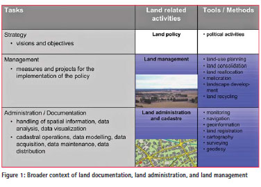
Therefore, land administration systems provide the basis for conceptualising rights, restrictions and responsibilities; land administration functions form the operational component of land management; land governance enables the determination of land policies that direct land administration systems and land management practices so that these can be effectively implemented to ensure sustainability.
By bringing together the various strands-land administration, land management and land governance -we can create a strong framework by which land and natural resources can be effectively managed to fulfil political, economic and social objectives, that is, to help realize sustainable development objectives.
Key elements for a spatially enabled society
In order to support this concept, the Task Force identified six elements, which are critical to its implementation. Without those six elements, the spatial enablement of a society or government would seriously be held back in its progress. They are:
Legal framework: to provide a stable basis for the acquisition, management, and distribution of spatial data and information;
Common data integration concept: to facilitate that existing spatial data -from government as well as other sources -respect a common standard in order to ensure interoperability and linkage of data for the benefit of all;
Positioning infrastructure: to provide a common geodetic reference framework in order to enable the integration of spatial data and information;
Spatial data infrastructure: to provide the physical and technical infrastructure for spatial data and information to be shared and distributed;
Landownership information: to provide the updated and correct documentation on the ownership and tenure of the land, fisheries, and forests, without which spatial planning, monitoring, and sound land development and management cannot take place;
Data and information concepts: to respect and accommodate the different developments in the acquisition and use of spatial data and information.
In terms of keeping a society spatially enabled, there are probably further issues that need to be considered, namely the educational framework, the technical and institutional development of spatial data management, the development of awareness on all levels of society -such as citizens, institutions, and decisionmakers -and the development and applicability of land management tools in order to make best use of spatial data. These elements, however, were not further discussed in the Task Force.
Legal framework
The legal framework is a key element in achieving SES as it constitutes an integral component of a jurisdiction’s institutional structures. The framework depends on the set of laws and regulations that govern behaviour and create institutional arrangements within a jurisdiction to facilitate the use, sharing, access and management of spatial information, services and technologies within, and between, different levels of society. Consequently, these also underpin the mechanisms of a jurisdiction’s spatial data infrastructure (SDI) as an enabling platform.
The ability of spatial data sharing and interoperability by reconciling often competing legislative policies poses a significant challenge. This is of particular significance for spatially enabled datasets as they often have multiple uses that were not anticipated in the original licensing conditions or in its creation, which could increase the risk of litigation should injury result from the inappropriate use of the data. One of the ways in which an SDI, as an enabling platform, can support the legal framework is to provide an avenue for governance. Governance plays a central role in SDI, and therefore SES, by enabling the creation of agreements that bind together the people and geospatial resources (data and technology) involved.
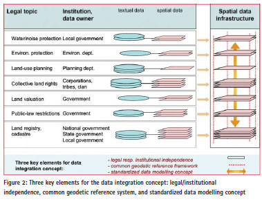
Common data integration concept
At first sight, a common data integration concept seems to be a rather technical issue. However, it has a highly political and institutional relevance, as depending on the concept, valuable information is either locked into data silos or it can satisfy the aspects of true interoperability and data sets can be shared and linked between the different stakeholder. Only then, a society can benefit as a whole.
There are three key elements for successful data integration: respect of the independence of the legal and institutional responsibilities / use of the same geographic reference framework / use of the same standardized data modelling and description concept. When these three key elements are respected, the linkage of data sets is facilitated and the wealth of geoinformation can be taped into.
Positioning infrastructure
The geodetic datum is widely recognized as the most fundamental layer of any spatial data infrastructure. Traditionally, it has been realized through the placement of permanent survey marks and carrying out surveys to generate accurate latitudes, longitudes and heights for those marks. A global trend during the last decade has been to move away from survey marks and to establish Global Navigation Satellite Systems (GNSS) supported by Continuously Operating Reference Stations (CORS). These enable a high accuracy and a continuously monitored realization of the geodetic datum. GNSS can be considered as a most truly global infrastructure available today. They underpin the broad spatial enablement of our societies by providing the ubiquitous ability to hundreds of million mobile phone users to locate themselves and to obtain location based services. The ubiquity also creates hunger for improved performance, which helps to make GNSS evolve from an industrial to a mass market application, supporting navigation, road safety, vehicle guidance, collision warning, etc.
The implementation of higher quality infrastructures, such as CORS, providing even higher accuracy can only be justified in densely populated areas, while the extension into rural and remote areas makes sense, only when the business case is broadened beyond surveying and spatial data, for example for machine guidance in agriculture, construction or mining. As such, the positioning infrastructure will come to be seen in the coming years as the fifth infrastructure after water, transport, energy, and telecommunications.
Spatial data infrastructure (SDIs)
SDIs have emerged as both a fundamental network infrastructure, as well as an enabling platform to help achieve the vision of a spatially enabled society as it aims to connect people to data to facilitate decision-making. An SDI comprises both social and technical components: people, access network, policy, standards and data. As such, the successful development and implementation of an SDI depends on understanding the significance of human and community issues, as much as technical issues, which impact on the exchange and sharing of spatial data and services; that is, its interoperability with other systems and information.
The concept of SDIs has evolved with time, resulting in three main approaches -hierarchical, network and most recently, that of a marketplace. The role that SDI initiatives are playing has also changed from being organisationbased, to becoming an enabling platform for SDIs of different scales and hierarchies. A growing demand for access to timely and precise spatial information in real time about real world objects to support more effective crossjurisdictional and inter-agency decisionmaking in priority areas has resulted in SDIs becoming a key infrastructure in realising a spatially enabled society.
Landownership information
Land ownership is connected with ‘place’, as it concerns ownership, value and use of a defined lot of land. Depending on the jurisdiction, this lot of land can have various spatial dimensions, from a single point value to an accurate representation of its boundaries. The usual representation, however, is the ‘cadastral parcel’, which is uniquely defined to also make it suitable to serve as the key data element for the spatial reference.
The cadastral parcel finds itself defined as a core element of the EU INSPIRE Directive, for which the specifications were developed as official guidelines. Also on national levels, the cadastral parcel is a core element of geodata infrastructures providing land ownership data to authentic base registers.
As such, cadastral parcels are part of something bigger, called land administration system. It is generally accepted that a LAS is to be based on land ownership data.
Data and information concepts
Along with the digital revolution, geodata and location data are nowadays managed and consumed in digital form. Electronic mapping, smart phones, Google maps, Bing maps, location based services, meeting friends and finding local restaurants are all mainstream applications in the ‘location revolution’.
The sources of geodata stem from the public as well as the private sector. The public sector establishes basic geodata infrastructures on national as well as international levels, while the private sector provides initiatives such as satellite imagery, open street map, or other crowd-sourced data. The traditional role of Governments collecting official geoinformation is more and more challenged by private sector activities, which however often suffer in terms of systematic and consistent coverage and unknown quality. The future developments will be interesting to follow as global technology companies understood the power of location and their strategies reach far beyond existing markets using location as just one market element. The fusion of different sources of geoinformation will be transforming the geospatial information landscape as society has access to an ever increasing set of geospatial information and associated location based information. The delivery of these innovative services using the billions of mobile phone users across the world will ensure to reach a fully inclusive spatially enabled global society.
Discussion and examples
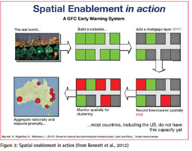
The development of a society towards spatial enablement can be thought of as a continuum over several steps, which may happen for each key element at different speed. When a society has attained full spatial enablement, decision-making procedures may become feasible, which were not possible before. The following two examples illustrate what this might be.
A first example shows how the cadastral landownership layer can be complemented with mortgage and foreclosure information. Such information can then be aggregated at a state or national level, which allows detecting patterns or clustering phenomena. The spatial representation of such phenomena can serve important political decisionmaking processes (see Figure 3).
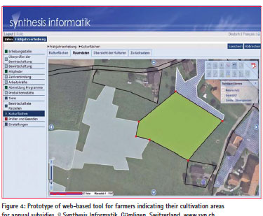
Another example is a project in Switzerland, where a web-based portal is being developed for farmers to declare their annual cultivation areas online. Farmers are receiving subsidies on the basis of the crops and areas that they are cultivating. Based on the cadastral landownership and an orthophoto layer, the portal offers tools such as easy-touse snapping functions and standard forms to be filled out (see Figure 4). This will allow a much more direct and efficient notification process for farmers to provide their data and receive their subsidies. Such a solution would not be possible without a complete documentation of landownership and the interoperability of the information, both of which are in place in Switzerland.
Future directions
The future of spatial enablement and the realisation of a spatially enabled society, lie in it being a holistic endeavour where spatial (and land data) and nonspatial data are integrated according to evolving standards and with the SDI providing the enabling platform.
The concept of SES is offering new opportunities for government and wider society in the use and development of spatial information, but it needs to move beyond the current tendency for the responsibility to achieve SES to lie solely with governments. SES will be more readily achieved by increasing involvement from the private sector, and in the same vein, if the surveying and spatial industries start to look toward other industries for best practices in service delivery. Future activities need to take into account emerging trends in geospatial information and the new opportunities they present for the application of spatial technologies and geographic information. Future activities will essentially need to be fit-for-purpose, ubiquitous, transparent and seamless to the user. Additionally, there is also a need to consider the developing challenges that are arising from having differing levels of maturity in use and management of geospatial information, and perhaps a need to increase the focus on critical areas that are proving to be challenging.
Even as we begin to think about what the future of SES may look like, at its heart, the realisation of SES will always be predicated on the legal framework, data integration abilities, positioning and network infrastructures, landownership information and the various data and information principles. These key elements need to be embraced by the established professional communities or otherwise they face the threat of being taken over by those groups that better understand the messages of change. As surveyors, land and spatial information specialists, it is imperative that we understand the technological changes, developments and possibilities, so that we can convey these messages and requirements to our partners, to political decision-makers, and to society at large.
In 2009, the FIG established a Task Force to look into the issue of «Spatially Enabled Societies» (SES). A three-year effort together with representatives from GSDI and PCGIAP led to a publication compiled and edited by Dr. Daniel Steudler, Chair of the FIG Task Force on Spatially Enabled Society, and Prof. Dr. Abbas Rajabifard, President of the GSDI Association. The publication is available as FIGPublication No. 58 from www.fig.net.
The contributions for the six key elements come from Jude Wallace, Serene Ho, Jürg Kaufmann, Matt Higgins, Paul van der Molen, Robin McLaren, Abbas Rajabifard and Daniel Steudler. The summaries for this article have been edited by the authors.


 (149 votes, average: 1.10 out of 5)


Leave your response!