| Applications | |
The effects of climate change on land tenure in Zanzibar Islands
This paper addresses implications of climate change and land tenure in Zanzibar (focusing on) alarming issues on population growth, coastal development and sea level rise, land uses and land policy |
 |
|
Zanzibar has a very high population density of 500 per sq. km, in a land area 2,650 sq. km. This ratio is alarming when it comes to actual development planning. After the 1964 Political Revolution, a number of land reforms were instituted aimed at changing the ownership of land rights and the system of land administration, the main concern being land scarcity and an inadequate land management system. Poor land registration implies that land tenure in the two islands is a challenge. The informal land distribution has involved mainly the urban poor, which is one of the biggest administrative challenges facing the responsible institutions. Therefore, there is a need to undertake a study in order to improve land management systems and human settlements development and this will help in achieving the targets indicated in the Vision2020.
Zanzibar Government has established the Department of Disaster Management, to monitor climate changes and improve information based on disasters in the islands. The Department is still new and is facing many challenges including professional staff in disaster management, up to date equipment and centres of monitoring disaster information.
The impacts of climate change can be expected to have a range of direct impacts on land use systems, with both direct and indirect repercussions for land access and land tenure. Shifts in climatic regions, rising sea levels and increases in extreme climatic events are likely to reduce the availability of land suitable for human settlement and agricultural production, as a result of temperature increases, sea level rise and associated flooding, and restrictions in water supply, leading to population migration and displacement and the need to adjust livelihood patterns to new circumstances. These changes will involve increased competition for land and are likely to trigger changes in access to land and land tenure arrangements.
Institutional arrangement
Zanzibar commission for lands
The role and functions of this institution is to prepare and implement major land issues including development of digital mapping, prepare National land use plans, Local land use plans, tourism- zoning plans, urban-master plans for the towns, land adjudication and registration and develop digital database (land information system) land parcels. The first National Land Use Plan was prepared in 1995, and the second was in 2014, the only land use plans covering both Unguja and Pemba. Implementation of plans are facing several problems including limited financial and skilled human resources, rapid urbanisation and socioeconomic development, an inappropriate legal set-up and the lack of resources for monitoring land use developments.
The Zanzibar land Information Systems which started since1995 has yet not shown any progress. Many consultants have tried to develop sustainable system for Land Information. However the traditional techniques used for capturing land information (surveying and mapping methods) are not sufficient to cope with the demand for managing and coordinating land matters. Therefore actual qualitative and quantitative use of land information is also limited due to low awareness of its importance among planners and decision makers, and a lack of institutional and policy arrangements. Information on land accessibility and application is not coordinated for spatial development projects.
The Commission for Lands has started the exercise of land adjudication and registration in both islands, but the process is very slow. The target set up to 2015 by the Commission is 8,000 parcels to be registered. The donor support ended in December 2015, less than half of the target were demarcated but not registered. Land registration is a very important factor in land administration and in securing land rights. It guarantees the right of occupancy for individuals legalises transfers of land and can be used to acquire loans. However, most Zanzibaris are not aware of the land registration process and its benefits. The major challenges facing the land sector are:
– Donor support projects have time limit. There is no sustainability after the donor support ends.
– The government funds to continue the programs are limited.
– Lack of enough professional staff at office and in the field. Land information and GIS experts are not enough to handle all LIS work.
– Implementing and monitoring of on-going projects is another issue. Due to limited staff goals set always fail to meet the targets set.
– Increase of informal developments in urban and the coastal areas.
– Land pressure especially in the peripheral urban and emerging new settlement of coastal areas affect forest land and other natural resources.
Zanzibar environmental management agency and department of environment
These two government institutions are set up to monitor and develop environmental guidelines for sustainable uses of natural resources. There have been major success stories of these two offices. They have developed Environmental legislation, environmental guidelines and EIA guidelines and standard for both investments and individual developers. The Department of Environment has already developed Zanzibar Climate Research document (Technical Report, May, 2012). It spells all challenging issues climate changes in Zanzibar Islands and its mitigations measures. These institutions are key offices for developing environmental awareness by using different Medias and nongovernmental organizations (NGOs). The departments commissioned the Institute of Marine Sciences (University of Dar es Salaam, 2007) to make study of beach erosion status in both Islands. The implementation of the findings and monitoring is another challenging issue of many Zanzibar Government offices.
Zanzibar department of disaster management:
Zanzibar Department of Disaster Management is in the Second Vice President’s Office which oversees and coordinates all issues related to disasters in Zanzibar. In order to strengthen the institutional and coordination capacity as well to insure that disaster risk management is a multi- sectorial issue, the department with the support by UNPD formulated the Disaster Management Project. The main components of the project include formulation of National Operational Guidelines and Monitoring and Evaluation Framework.
The department now is more conducting training at the local levels. The Education Unit section is taking a big role to strengthen information and communications.
Disaster incidents are increasing in frequency and intensity due to changing weather patterns. Recently, Zanzibar experienced flooding in 2005, 2011 and 2014 which affected more than 1000 homes, displaced 10,000 people and damaged infrastructure in both islands.
Other institutions which support the department of Disaster Management include Police Force, Meteorology Department, Fire fight and Rescue, Military Force, NGOs and National Disaster Steering Committee chaired by the Zanzibar President. The department has established District Disaster management committees to monitor and report them to Regional offices.
However, the department lacks enough human resources and technical staff of monitoring and predictions such GIS teams to assess the risks zones and other high tech equipment. It also needs modern office to facilitate their operations. In addition to that, the following are also affecting the smooth operations of the department:
– Lack of a system to detect disaster and put inform the government accordingly.
– Risk assessment results are not fully utilized for intervention and planning purposes due to inadequate financial resources.
– Ability to assess the full range of consequences and vulnerabilities, especially secondary impacts, comparative economic analysis and assessing non-monetary costs
Urbanization
Zanzibar is experiencing major transition process that has been and will be affecting the country in many years to come. The urban population and urbanization is rapidly increasing. In 1988 little more than 30% of the population was living in the towns. In 2002, it was almost 40 %, (2012 census report)
Zanzibar islands have three major towns, Zanzibar Municipality, Chake Chake, Wete, and Mkoani. Zanzibar Municipality is the administrative and commercial centre. The urban economy is also developing fast attracting more people to migrate to urban areas. Tourism and other service sectors have increased in the Zanzibar economy.
Population growth generates a demand for land use changes for housing, infrastructure, and other use. Protected areas for forest and agriculture have been shrinking. Large amount of urban land is unplanned, many living in areas of high risk, prone to floods.
Climate change land related issues
Land use planning
Zanzibar has prepared many land use plans at different hierarchies since 1990s when Finnish government signed agreement to support the Zanzibar government in land and forest sectors. In the year 2002 and 2015, the government prepared strategic plans at different levels with the help of consultants. It prepared the National Strategic Development, Regional Plans and Local Village with the same concept used in the country of Mauritius. In 2014, the Master Plan for Zanzibar Municipality was prepared under the sponsorship of World Bank (Urban Services and Sustainable Program) package.
These Land use plans aimed at improving the living standards with the style of minimizing the land under development. The idea of compact development was introduced to reserve more land for other uses such as forests, agriculture and reserve land.
Zanzibar has experienced a high speed of uncontrolled development at the periphery of the urban areas. There are conflicts of developments. The compressive land use plan should consider the protection of nature, valuable agricultural land and sensitive areas. The informal settlements outside the municipality have increased. Agricultural land and sensitive areas are being changed to residential at an alarming rate. Low income communities take the advantage of building their houses close to flood prone areas because the land is cheaper in those areas. The combination of spatial planning with enforcement of protected areas should include:
– Participatory planning
– Raising awareness of protected areas such water sources, agricultural land,
– Minimizing the impacts of development on valuable lands by providing guidelines and standards for the proper protection of these lands.
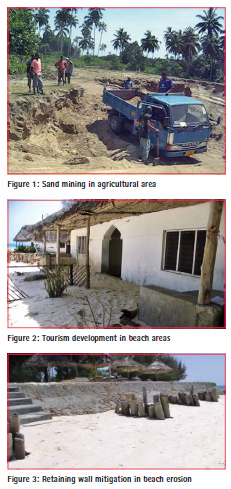
The adverse effects and environmental impact of land degradation caused by unsustainable excavation of nonrenewable natural resources in Zanzibar have evidently become irreversible. The aim is to reduce land degradation through sustainable use of non-renewable natural resources. The use of alternative construction materials and the development of proper skills to improve the degraded environment are very important. Figure 1.
Environmental degradation
This phenomenon results from poor land use patterns and other practices that lead to waste and destruction of ecological patterns. Environmental degradation is caused by overgrazing, destructive tilling practices on sloping landscapes, monoculture, unguided and uncontrolled use of fertilizers, bush burning, overfishing, poor methods of quarrying and deforestation.
Wetland degradation occurs as a result of drainage, overharvesting and burning of wood for brick making, as well as settlement and development projects like industries and irrigations. Encroachments in protected areas destruct habitats and loss of flora and fauna.
Tourism and coastal areas
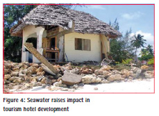
A Tourism Zoning Plan was prepared in 1995 to guide the coastal development in a sustainable manner. A number of tourism zones along the coasts were prepared and with services and infrastructure allocated to govern the socioeconomic developments. The tourism plan has been unsuccessful in regulating development in some coastal areas Coastal resources of Zanzibar constitute a complex interconnection of a variety of ecosystems (both terrestrial and marine). There has been over utilization of coastal resources, due to multiple uses, such as hotel and settlement construction, salt farming, and others that have led to severe damage to of these resources.
The risks of climate change to coastal areas associated pressure on land demand for tourism are a key issue for Zanzibar, particularly from sea level rise, but also from other factors such as from sea surface temperature, salinity, wind speeds and direction, etc.
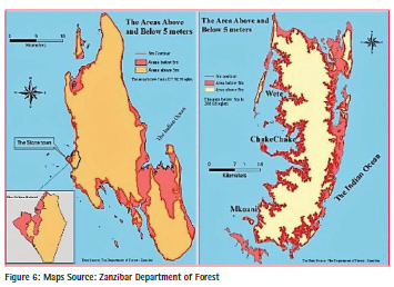
The direct impacts of sea level rise will be felt primarily in the so-called Low Elevation Coastal Zone (LECZ) which can be defined as “the contiguous area along the coast that is less than 10 metres above sea level.” This area comprises only 2% of global land area but contains 10% of the world’ population, and 13% of the world’s urban population. (McGranahan etal).
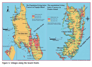
Human settlements along the coastal lines have increased effect of coastal erosion. Unguja which is the main island has around 224,000 people live below the 5 metre contour line (with 281,000 below the 10 metre line). For Pemba islands around 281,000 people live below the 5 metre contour line (with 309,000 below the 10 metre line).
In many island areas, the population is fairly concentrated around the coastline, and these leads to relative high exposure. When compared to current population, 29% of Unguja and 54% of Pemba population are within the 5 metre contour zone.
There are also other reports of increasing erosion, particularly on the eastern coast of Zanzibar possibly from the strengthened north-eastern monsoon and increase of wave activity due to increasing wind regime. Most of the settlements in the island are along the coastal lines some are less than twenty meters from highest water marks.
Zanzibar’s coastal resources offer great potential for diversifying the islands’ economy. The economically valuable attributes include its diverse nature, various ecological systems such as coral reefs, mangroves forests, sandy beaches, swamps. This zone now is highly vulnerable and prone to physical damage. Effects related to the use and exploitation of those resources mainly are due to development activities which combine fisheries, tourism, agriculture, human settlements, quarrying, waste disposal and transport. In view of the increasing pressures on the coastal zone, the following issues have been identified:
– Degradation, the unregulated resources exploitation, coral reef damage, tourism development pressure on fishing resources.
– Land use conflicts, pressure on marine islets by competing uses of tourism, unabated allocation of lands for hotel development along the coastal zones conflicting with traditional villages and local economy.
– Mangrove cutting, sand and rock mining, reef destruction, sea level rise by natural and human effects.
– Carrying capacity, the population increase of human activities in the coastal area has triggered the overuse of coastal resources such land, forest, building materials, marine species, protection of indigenous plants,etc.
– Minimum or lack of community participation in coastal resources management
Land Policy Registration
Zanzibar has established the first comprehensive land policy and legislations in 1990s, aiming of regulating land administration and improve security of tenure. The Tourism policy and agricultural policy were also put into place to stimulate proper land use planning. But due to the speed of economic changes and increase of tourism sector, these policies and legislations did not work well as expected.
There has been very slow process of provision of secure land rights under a diversity of forms, including the recognition and devolution of responsibilities for land registration, promoting land access for low income peoples, upgrading of tenure and infrastructure in urban informal settlements; improving equality in the distribution of land. The management of natural and non- renewable resources and inclusive frameworks for stakeholder involvement and management of land conflicts better governance in land administration are not yet in place.
Socio economic on Land Use
The poor are most vulnerable to the impacts of climate change and variability, and women are over- represented amongst the poor. Approximately 70 percent of the world’s poor are women and their vulnerability to natural disasters and environmental hazards is further accentuated by questions of race, ethnicity, and age (IUCN 2007).
The people most at risk from climate change are those living in affected areas, who are least able to avoid the direct or indirect impacts (as a result of having poor quality or poorly located housing), being physically more vulnerable, and least able to cope with the loss of income, livelihood assets, ill health and injury. In low income populations, women’s vulnerabilities in all of these respects tend to be more pronounced, in part because their limited access to and control over assets such as land exposes them to all of these risks (Satterthwaite et al). In both rural and urban environments, predisaster patterns of gender inequality can be exacerbated and are likely to be reflected in greater difficulties faced by women in the aftermath. In developing countries low income communities are built their home without having land tittles and when the government evicts them mostly do not get compensation.
Energy
The Zanzibar Energy Policy 2009 set out the need for norms, codes of practice, guidelines and standards to facilitate the creation of an enabling environment for safe use of energy efficient appliances and in particular appliances based on environmentally friendly technologies. It included a policy statement that Zanzibar shall introduce limits on standards for import of electrical appliances. Energy efficient equipment shall be promoted by lowering import duties for such goods. It also highlighted that a major obstacle for the development and market uptake of energy efficient technology was the higher (relative) capital costs) and the need to addressing financing. At the small scale it highlighted the potential role of micro-finance institutions in facilitating investments in energy efficient equipment and for large scale investments, energy efficiency funds.
The escalating demands for wood fuel, settlement expansion are the most important drivers of deforestation. The distribution of the main energy sources used in Zanzibar is: biomass fuels 74%, petroleum products 21% and electricity 5% (The Economic Climate Change Study – 2012). It is estimated that periurban and rural population cooking energy needs on biomass reached 40% and 96% respectively. This situation pushes the forest degradation and deforestation.
Mitigations and adaptation
Urbanisation
– Set development strategies to reduce the effects and guide urban growth in order to minimize the effects of investments while on environment.
– Set population development strategies on coastal settlements and tourism developments.
Land use planning
– Improve land and natural resources information including improve inventories on land in urban and rural areas,
– Improve analysis and mapping of natural hazard risks for informal settlements,etc.
– Dykes construction for seasonal water / flood management, some short term displacement and resettlement; better land use and water management in irrigation systems.
– Greater security of tenure to facilitate adaptive management; resettlement and facilitated migration; compensation for land loss; improved land inventory;
– To ensure that the development of rural and urban settlements are proportional to the rapid growth of population and the need for basic services.
– Conservation management and sustainable utilization of forest and marine resources to be strengthened
– Develop a set of ordinances or regulations and associated standards intended to control aspects of designs, constructions, materials, alteration and occupancy of structures that are necessary to ensure human safety and welfare including resistance to collapse and damage during disasters.
Tourism and coastal areas
– Effective supporting broad based sustainable developments in the coastal areas.
– awareness raising on the importance of creating a positive balance between conservation and the use of local resources
– introduction of coastal protection and coastal zone management to protect tourist infrastructure – diversity of tourist product to reduce over dependency on marine environment
– risk management skills organised by education, NGO’s and other institutions in coastal areas
– Forming a professional team of land sector to review and monitor the tourism zoning plan changes and its effects on the communities interests and nation at large.
Land policy registration
– Develop land policy based on inclusive and consultative process that makes provision for those high at risk natural disaster and those with poor tenure security.
– Establish guidelines of land registration system
– Develop institutional infrastructure, good governance, spatial data infrastructure, ITC infrastructure and recruitment of land professional skills.
Socio economic on Land Use
– Measures to protect the poor and vulnerable from loss of livelihood resources and develop the opportunities available for them to gain direct benefit as a result of climate change mitigations measures.
– Prepare hazard map that highlights areas that are affected or vulnerable. Hazard maps are useful in disaster management in order to address prone areas to hazards.
Energy
– Develop planning guidelines and building codes for efficient energy use such as building design standards to facilitate safe and sustainable energy use.
– Promote alternative energy use such as of solar and wind power through tax relief and lowering of tariffs.
Conclusion
Policies regarding land sectors such as agriculture, land and tenure, forest and water management, environmental management including urbanization need to be improved and demand for introducing an integrated approach to deal with climate change adaptation. To meet this challenging demand, land policies can play a leading role in improving adaptation policies in the face of climate change. A thorough review of literature is made in this chapter is to explore the ways of developing integrated approaches to integrate climate change issues related to land into land policies.
The land related instruments such as land use planning, land management and administration can play a role in adapting and mitigating climate change. However, Zanzibar needs to put all these together in reality with enough funds and technical/scientific human resources to with climate changes
References
1. February 2002, UNDP, development Program (Tanzania). Disaster Management Project
2. October 2012. East African Community. Disaster Risk Reduction and Management Strategies (2012-2012) Final Report
3. May, 2012. Technical Report: economics of Climate Change in Zanzibar Vulnerability Impact and Adaptation.
4. Zanzibar Research Agenda-2015-2016
5. December 2012, Department of Disaster Management, Revolutionary Government of Zanzibar, (the Second Vice President Office) Report on Support to Disaster Risk reduction Information and Communication
6. 2012, Draft Zanzibar National Land use Plan
7. Julian Qua, Nat Dyer. 2008. Climate Change and Land Tenure. The Implication of Climate Change for Land Tenure and Land Policy (FAO Working Paper)
The paper was presented at Small Island Developing States (SIDS)Workshop, 30 April-1 May 2016, Christchurch, New Zealand, May 2–6, 2016


 (No Ratings Yet)


Leave your response!