| Conference | |
Survey Camp at Nainital, India
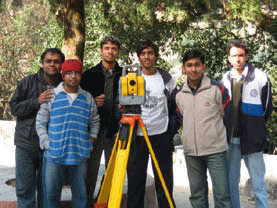
Survey Camp, Nainital was held from 28th November – 7th December, 2008 as part of the academic curriculum at IIT Kanpur. The site chosen for the camp was Nainital which is set in a valley containing a pear-shaped lake and is bounded by a great snowy range which forms the central axis of the Himalayas at an altitude of 1,938 metres above sea level. In this camp a batch of 80 students conducted survey operations covering Nainital and its adjoining areas using hand-held GPS, Total Station and Geodetic GPS. In addition, the students were introduced to some of the latest surveying techniques like LiDAR. The camp was coordinated by Dr. Bharat Lohani a faculty with IIT Kanpur.
Task DescriptionMapping of Ashram using Total Station :- Students were divided into groups of 7-8 and each group was allotted a Trimble 5600 DR200+ along with the accessories. This task involved mapping of the campsite, including all features at a scale of 1:500. The complexity of terrain required each group to establish controls using two closed traverses with each comprising of 6-7 stations. Free and known station techniques were used for determination of the next station’s coordinates. The coordinates for the free station method were obtained using the Geodetic Differential GPS with reference station being at IIT Kanpur. More than a thousand points were observed for mapping of the campsite. Traverses were adjusted for horizontal and vertical closing errors. The corrected coordinates of features were imported into ArcGIS where using Northing, Easting, Elevation and ID of points detailed map of the area was made including contours with CI=50cm. Road Profiling using Total Station :- Using the same total station equipment, students were assigned road profiling of a 200 meter long road in which they had to generate data for increasing its width from 3 to 5 meters and also provide suggestions regarding soil removal and filling possibilities after inferring from the longitudinal and transverse profiles. Cross sections were taken every 20 meter along the road where Northing, Easting and Elevation at various points across cross-sections were recorded. Reflectorless method was employed for inaccessible points. As retaining walls and descending steep slopes are major factors in determining methodology for widening the road a number of points were observed on both sides besides normal features like manholes, trees, electric poles etc. The points were imported into ArcView and topographic map of road along with various profiles were prepared. Mapping of road routes using hand-held GPS :- The Leica GS-5 instrument was used to make maps of routes from campsite to city and back named G1 and G2. All important landmarks like hotels, schools, government buildings etc. enroute were plotted in ArcView after importing the shapefiles. Points were recorded only when more than three satellites were visible. WGS-84 and UTM were used as the ellipsoidal reference and projection system. Computations, Corrections and plottingFor station establishment, two methods were used: Free station method: Using points whose coordinates were known through Differential GPS. Known station method: Used when coordinates of station point and reference object were known. Free station method is more accurate as propagation of errors does not take place. After completion of work, traverse is closed and closing error is determined in horizontal and vertical. These errors are then adjusted and corrected coordinates are calculated satisfying the condition that coordinates of a point do not change when returned to the same point after traversing the loop. The corrected coordinates are imported to ArcView for detailed cartography and generation of profiles. Outcome of Survey Camp: Tangible and IntangibleBy the camp’s end, students had prepared detailed maps of the Campsite, Road Profiling and road routes. The ArcView shapefiles were converted to the .kmz format which is readable in Google Earth and facilitated publishing the work over Google Earth, thereby making it available over internet. Apart from these files (.kmz and .shp), students were also required to submit a comprehensive report about the camp. Calculations and corrections were applied to various observations and were compared to have an idea about their level of accuracy and to have an understanding that which technique could be used in the field and under what conditions. http://home.iitk.ac.in/~abhinavg/surveycamp/ By Abhinav Gupta (abhinav_gupta_1988@yahoo.com) & Salil Goel (salil.wtr@gmail.com), Final Year Undergraduates, Department of Civil Engineering, IIT Kanpur, India |


 (No Ratings Yet)


Leave your response!