| Application - New | |
GNSS education: prospects and challenges
Academicians share their views and experiences on the prospects and challenges of GNSS education and suggest the way forward |
GNSS education reform is needed
 |
|
 |
|
Satellite navigation has become a component of national infrastructure and therefore one of the pillars of the modern civilisation. This inevitably requires knowledgeable, skilled and competent professionals who will be able to advance, modernise develop, and operate satellite navigation systems and their applications and services. Capacity development in the GNSS segment and attracting talented people to the field of satellite navigation has already been recognised as an important subject. However, education in the satellite navigation discipline still suffers from a number of both inherited and emerging challenges, rendering it not completely suitable for the task.
First of all, satellite navigation is still considered a mixture of the other (mostly applied) scientific disciplines, that shaped the satellite navigation through the period of its development. This leads to curricula biased towards disciplines, that claims inheritance and foster particular education approach common to them. Satellite navigation community comprises professionals with various academic education backgrounds, spanning from mathematics, computer science and electronics engineering to geodesy, geography and transport and traffic sciences. While diversity should be considered and advantage rather than the opposite, significant problems arise from the fact that those specialists are still firmly anchored in the way of thinking and operation characteristic for their fundamental scientific discipline.
Establishing satellite navigation as a separate applied science discipline with its own philosophy based on the foundations of fundamental scientific disciplines (mathematics and statistics, in particular), and new common-interest disciplines (such as computer science) will facilitate recognition of satellite navigation and allows for identification of common capacity requirements regardless of satellite navigation sub-specialisation.
Satellite navigation has significantly and rather quickly changed the scope of its application. Considered a technology merger that will foster and advanced navigation, satellite navigation now encounters the fact that majority of GNSS applications belong to the nonnavigation category. Generation of massive positioning data sets that are further processed using statistical and machine learning methods to reveal the hidden patterns and knowledge, timestamping of financial transactions, taming vulnerabilities and shortcomings to create robust and resilient PNT services, synchronisation of large spatially distributed networks (internet, mobile communication networks, public broadcast networks, power networks, intelligent transport systems etc.) and artificial intelligence and robotics together overtake massively the traditional navigationrelated GNSS applications. Making advancements and developments in such a variety of new scenarios of usage requires new and advanced capacity in methods and techniques for statistical/machine learning, modelling, management of spatial data and computing in general.
Challenges of the kind are scientifically and intellectually attractive for talented people across the scientific disciplines. GNSS core and application development, and resilient GNSS development already face a shortage of professionals with the appropriate knowledge and skills, competing with numerous similar fields. However, the structured offer for academic education in satellite navigation is still sparse.
Organisations such as Stanford University in the US, Imperial College and University of Nottingham in the UK, and Ecole Nationale de’l Aviation Civile (France) and Politecnico di Torino (Italy) in the EU offer systematic way for academic study of satellite navigation. Numerous other universities offer partial GNSSrelated education through courses related to particular discipline, depending largely on the enthusiasm and scientific results of individual scientists and educators.
An important move forward was made by the United Nation’s Office of Outer Space Afairs (UN OOSA), that worked out an international MSc study curriculum, now used in the UN regional education centres in India, Morocco, Nigeria, Jordan, Mexico, Brazil and China (Beijing). The curriculum would need some modifications, considering the new market share of non-navigation GNSS applications and requirements for additional capacity. All the institutions providing GNSS-related academic education are not balanced in their scope and intentions, and education materials are still scarce and provided on individual basis. Finally, mobility of students and educators passed its infancy phase, but still remains at the levels that struggle to provide contribution to advancement of GNSS education at the needed scale.
We can share our experience in advancing GNSS education through a pragmatic, generalised and problem-oriented education approach in our satellite navigation academic education activities that span from the GNSS-related MSc courses in computer engineering at Faculty of Engineering, University of Rijeka, Croatia to GNSS applications MSc course at the UN Regional Centre, Beihang University, Beijing, China. Founded in mathematics, statistics and computer science, we presented materials in a structured way, and promote research activities and practical problem-solving approach based on utilisation of the open-source statistical computing R platform, GNSS Software- Defined Radio (SDR) for methods and techniques for signal and information processing in base-band and navigation (application) domains, and open-access material that passes our scrutiny.
Addressing the GNSS-related problems emerging from different GNSS application disciplines using experimental data, and bespoke or open-source (SDR and R-based) software render students capable of fast capacity end experience development on real problem solving.
Students are also encouraged to present their research results and accomplishments during major international conferences, where they can discuss subjects with the other colleagues and prominent international GNSS experts. Those activities can be supported by programmes and projects led by the UN OOSA and its International Committee on GNSS (IGS).
A proper GNSS academic education and professional advancement is essential for sustainable development of satellite navigation. Resolving issues related to GNSS deployment in steadily growing number of GNSS-based applications and services requires highly-capable GNSS professionals with broad knowledge and skills. Consequently, the GNSS academic education and professional advancement need a re-structuring reform that will assure the competent GNSS scientific and development community for the decades to come.
Good prospects of GNSS education in Indonesia
 |
|
 |
|
The development of higher education in geodesy in Indonesia has been started since the Dutch colonial era, particularly when they established Technische Hoogeschool te Bandoeng (Technical High School in Bandung) or TH Bandoeng in 1920. This school was primarily established to fulfil the need for professional engineers to be employed in various sectors. In early curriculum of TH Bandoeng, geodesy related subjects were only minor courses that were taught to civil engineering students. After three decades, in 1950, the curricula completely changed and most importantly geodesy became a department (Department of Geodesy). It was a milestone of the development of higher education in geodesy where geodetic science and its practical aspects were about to evolve into the current shape (Currently the department offers the programs for under/post-graduate students).
It is also important to mention that, in 1950, TH Bandoeng merged with the University of Indonesia and changed its name into Bandung Faculty of Engineering. Furthermore, Bandung Faculty of Engineering was officially declared became an independent university and (again) changed its name into Institut Teknologi Bandung or ITB. Therefore, it can be said that, in Indonesia, the development of higher education in geodesy started from ITB and it was then spread over the whole country.
Since 1950, higher education in geodesy focused to serve the Indonesian government that requires graduates with high competency in survey and mapping. As a large-scale geospatial information for supporting national development has urgently been required, in 2003, the Department of Geodesy transformed itself into the Department of Geodesy and Geomatics Engineering. This transformation significantly improved the curricula by considering the recent growing of geodetic science and technology. Furthermore, the department moved from Faculty of Civil Engineering to Faculty of Earth Sciences and Technology. This puts geodesy into a much broader perspective: earth sciences.
Recent challenges and adaptation of the curriculum
The archipelagic country of Indonesia is located in an equatorial region (6°N – 11°08’S and 95°E – 141°45›E) and lying above three different active tectonic plates. These geographical and tectonical situations have made many limitations for the national development. As an example of such limitations is that establishment of the nationwide vertical and horizontal reference frames becomes difficult since one should consider the Earth’s dynamics over the Indonesian region.
Furthermore, establishment of the vertical reference (geoid) becomes problematic since marine and land geoids should be determined using different techniques and technologies. Unification of the vertical frames is another problematic issue. In addition, acquisition of geospatial data over the Indonesian region should thoroughly be accomplished and the use of state-of-the art positioning technologies, such as Global Navigation Satellite System (GNSS), becomes mandatory to get fast, accurate and reliable results.
The use of GNSS should probably be treated differently since environmental effects over the equatorial region of Indonesia are typically different from those at the other regions. Some modifications in GNSS data processing might be required, in especially for low cost GNSS receivers, to optimally handle tropospheric and ionospheric effects that vary highly during night and day. On another side, a tremendous increasing of public needs for GNSS-based location service requires innovative and creative thoughts in order to build valuable geospatial industries.
In general, geodesy related works in Indonesia obviously requires considerable efforts in both scientific and practical aspects of geodesy. The cost for accomplishing such works becomes expensive. However, these problems and limitations should positively be viewed as challenges to enhance the quality of higher education in geodesy. Here, new approaches and innovations in geodetic observations and the data processing are necessary to get fast, accurate and reliable results with relatively low cost. Close collaboration with geospatial industries and government institutions are also important.
In order to face the recent challenges, higher education in geodesy in Indonesia should be able to produce graduates who are not only competence in doing practical surveying using the state-ofthe art technologies such as GNSS, but also having comprehensive fundamental concepts and communication skills. In 2013, the undergraduate curriculum of the Department of Geodesy and Geomatics Engineering at ITB has been revised to fully accommodate recent challenges and developments. It is important to emphasize that several subjects related to geodetic positioning and GNSS plays crucial roles in the revised curriculum. GNSS technology plays crucial roles in many geodesy and geomatics activities, such as accurate positioning and establishment of a global/national reference frame, as well as earth sciences studies. Several mandatory courses (basic physics, calculus, linear algebra, statistics, positioning and leastsquares adjustment, geometrical geodesy, satellite geodesy, geodynamics, and geodetic reference system and frame) are given as the basics materials to GNSS technology. Finally, promoting GNSS technology and its career prospects to students is one of our main concerns.
One Map Policy and recent prospects
Some years ago, the Indonesian government officially stated the One Map Policy, by which the government wants to have comprehensive geospatial informations over the whole region of Indonesian. The geospatial data shall be used to optimally manage the national development plans such as urban planning, land managemnent and natural resources. In order to guarantee the policy goes successful, the government declared the law no 4 of 2011 on Geospatial Information, by which acquisition of geospatial data is ruled and protected by law. One of the main points in such a law is that the Indonesian reference frame should be able to serve any kind of geospatial activities around the country. Furthermore, the reference frame should also consider the Earth dynamics.
This point implicitly recommends to use GNSS as a primary tool since it can be used for geodetic positioning and geodynamic studies. Immediate implication of this law was that the Indonesian government allocated huge budgets to establish a dense network of GNSS receiver for surveying and mapping as well as for Earth sciences studies. Currently, there are more than 150 GNSS receivers operate continuously over the country. It is worth to emphasize that the establishment of GNSS network does not only provide unique opportunities for the growing of geodesy and earth sciences, but also affect geospatial industries. This is obviously good prospects of GNSS in Indonesia, where universities can improve the quality of their education in GNSS, geospatial industries may significantly growth, and the government would get benefit from the university and industrial products, and finally the graduates may find jobs easily.
Difficult to find up-to-date resources
 |
|
GNSS is an all-encompassing field, covering a vast array of subject areas. Yet it is rarely taught on the curriculum in many top leading universities (in the UK, at least). There may be a few masters courses out there, but they are few and far between; when it comes to undergraduate courses, it may be touched upon in topics such as Surveying and Transportation within Civil Engineering, but usually very loose explanations are given without any technical depth or rigour. On the other hand, everybody, student and nonstudent alike, has heard of GPS and knows that it’s useful to get around somehow! With this in mind, perhaps the subject could be better promoted and marketed to attract potential newcomers into the field. Apart from Google Maps, the topic doesn’t gain much exposure in the academy, hence, other academic streams may be more obvious and appealing to pursue than GNSS, unfortunately.
As for myself, I studied an undergraduate degree in Maths, covering many applied maths topics, but never had an option to study positioning and navigation systems. I did, however, unknowingly develop useful mathematical tools to allow the study of GNSS in the future. The other part of my (master’s) studies that would become useful for the field of GNSS was engineering and sustainability. Here, I studied concepts such as risk and resilience of infrastructure, systems thinking and systems engineering, and transportation systems; all have been useful in my current research as a PhD student, new to the field of GNSS.
As a new student of GNSS it hasn’t been easy to navigate through the extensive literature. It can be difficult to find upto- date resources, with concepts clearly explained and targeted at beginners. It is always a challenge to find subject material pitched at the right level, and at the right depth – but there is some great material out there. One of the biggest challenges faced is knowing where to focus your learning as the field is so vast and is changing at a rapid pace!
One great help is supportive supervisors (with available funding) who encourage participation in external training and conferences. I think it is recognised that PhD students (and young professionals in industry) do often have limited exposure to, and education in, GNSS topics; so the European ESA and e-KnoT have run a number of educational training events, seminars and the infamous ESA/ JRC International Summer School. These are very useful for learning the fundamentals of GNSS and for networking with peers, as well as experts in the field. Again, they also highlight the wide-ranging nature of positioning and navigation. The UK’s Royal Institute of Navigation also put on useful conferences such as their Next Gen Conference for new research students to present their work and ideas, and their annual International Navigation Conference for all navigation enthusiasts highlighting current research trends, far and wide.
An advantageous attribute to working in the field of GNSS is the many opportunities for collaboration at the industry interface. There are a plethora of companies working on various aspects of GNSS development and applications across the globe. This is mostly a good thing for research and development, but can be problematic at times as private companies often want to protect their methods and IP – in contrast with the open, sharing approach in academia. In addition, GNSS research in academia undergoes careful scrutiny and peer review, whereas research in industry is generally less transparent and less rigorous, with more of a commercial focus. This usually makes it difficult to find and trust research methods and performance claims from industry. In this regard, I would certainly like to encourage increased transparency and rigour from industry, to aid research in academia.
Overall, I think there are excellent career prospects for young professionals, especially in light of new GNSS-related systems/applications in many regions, in particular, Europe (with Galileo). The various opportunities and future career paths, both within academia and industry, was certainly something that attracted me into the field. With so many recent developments and interesting world-wide applications in GNSS (and more generally, positioning and navigation systems) it is an exciting area of research to be in. I hope we can ‘spread the word’ and make this well known to future generations of aspiring scientists and researchers.
Specialization education on GNSS in Morocco, An important step to socio-economic development
 |
|
GNSS potential
The field of GNSS in Africa is gaining more importance especially in recent years because of the growing number of applications based on it in agriculture, aviation, geodesy and surveying, internet of things, land management, mapping, natural resources management, space weather and vehicle tracking. They generated important economic opportunities and contributed to human development and the improvement of social conditions.
GNSS has already shown its enormous potential in various fields. In addition, several recently developed geospatial data acquisition technologies are based on satellite positioning. LIDAR, Drones (UAV) and mobile mapping systems (MMS) are some examples. These technologies make technically and economically accessible sites that were not previously. Their use provides valuable help to decision makers for better management of the territory.
The field of GNSS is more than promising. This dynamic technological environment will require constant innovation on the supply side and services that go beyond the simple acquisition of localization but must meet the needs of analysis and management.
The majority of this growth will be generated by significant demand in regions outside Europe and North America.
Indeed, the Asian and African continents will be in the next decade the engine of this growth because of the potentialities they offer. In this context, the training of technical experts in GNSS, scientific research and academic partnership with the public and private sector should be encouraged. These are three essential assets for any sustainable development.
GNSS education in Morocco
In Morocco and many other African countries, a pioneering role was taken by professors and engineers of surveying and geodesy in the awareness of the importance of GNSS and in the development of many relevant applications. They were precursor of the first education opportunities of this important technology.
In this context, the School of Geomatic Sciences and Surveying Engineering (IAV Hassan 2, Morocco) integrated GNSS education into its training curriculum of surveying and geomatics engineering graduate program, since the early 1990s. It also contributed in various development and research projects related to this field with public administrations and private companies in Africa.
Aware of the needs in GNSS specialists to meet the requirements of the labor market and the expectations of decisionmakers and manufacturers, the School of Geomatic Sciences and Surveying Engineering (IAV Hassan 2, Morocco) established in 2016 a specialized master course on GNSS. This master is fully integrated in the School in partnership with the African Regional Centre for Space Science and Technology Education (CRASTE-LF) affiliated to the United Nations. This education program is the first specialized master on GNSS in Africa.
GNSS has basically an interdisciplinary nature. It comprises many key technology areas. Cooperation with other Schools and partners is required. In this context, several professors and experts from African and European institutions representing academia, research and industry contribute to this master course degree. Other experts from China, Russia and the United States of America participate through seminars and workshops in GNSS technology and applications.
To ensure the success and sustainability of this training, the master on GNSS is accredited by the Moroccan Ministry of Higher Education, Scientific Research and Executive Training and benefits from the support of the United Nations Office of the Outer Space Affairs (UNOOSA) whose contribution is vital.
Students motivation
Based on my experience at the university level, there is an increasing demand for training in GNSS in general. There is a large interest by students and professionals in getting trained in this field. Related to the specialized master on GNSS, three different categories can be identified:
– professionals seeking improvement and diversification of their activities and areas of application.
– recent graduates seeking to distinguish themselves from conventional training curricula and to position themselves with innovative and high valueadded projects in the labor market.
– candidates interested in navigation satellite systems research who want to continue into a PhD program after graduation.
Candidates of the specialized master on GNSS come from a variety of background disciplines: mathematics, electronics, geomatics, surveying and computer science. The selection of candidates to take the master course should be based on three criteria: motivation, the background and the previous academic results.
Indeed, motivation is a powerful energy that can lead to success. In this sense, candidates are encouraged to identify their future plans. Training on GNSS must enable them to achieve their goals. So they have to know what they want to do with their studies. Once integrated into the master course, the students are attracted by several aspects that increase their enthusiasm : the quality of instructors, the relevance and richness of course materials and the importance of the practice and the professionalization of the trainings : positioning algorithms, handling receivers, creating added value through the implementation of applications.
Reputation of institutions involved in the master course and partnership agreements concluded with other organizations are also important to drive motivation. They are the guarantee of the availability of internship opportunities, development projects and job offers. In this environment of education, students remain diligent in all classes and show a sense of progress. At the level of education, we insist, on the one hand, on the basic skills needed to understand the different technological aspects of GNSS and, on the other hand, on the practical tasks and projects that are assigned to students to stimulate their curiosity and their interest in this technology. This way, students can innovate through the development of new software, propose new applications of GNSS and are encouraged to the integration of many technologies and several sensors.
More effort and support are needed
To exploit the full potentials of GNSS, more efforts in education are needed. One of the main challenges is the ability to adapt the education programs to the recent and upcoming needs. In addition to the consolidation of the basics, the training must be in line with the technological and research evolution to meet the current and future needs of the market. Coordination between training, research and industry is very important to ensure the quality of GNSS graduates.
For the development of education program on GNSS, many issues must be taken into account : Effective implication of the providers to support education programs, Funding support for needoriented research, Support for international professors and experts (Funding air tickets and living expenses), Access to digital documentation and search results and the valorization of students projects to make them more attractive for the industry.
If we look at the enormous socio-economic opportunities offered by GNSS, and the increasing number of candidates seeking GNSS education, we remain surprised to note that the commitment of governments and the industrial world to specialized GNSS education is still insufficient. A lot of work and awareness-raising efforts must be invested to highlight the importance and relevance of this type of training.
Need to develop human resource capable of using GNSS
 |
|
Today we see more than 30 navigation satellites in the sky over Asia. They include satellites from USA (GPS), Russia (GLONASS), Europe (GALILEO), China (BDU), Japan (QZSS) and India (IRNSS). Theoretically, we need only four satellites to compute a position in 3-D. However, to guarantee accuracy, availability and reliability in different environments, terrain, location and dynamics, four satellites are not enough to provide 3-D PVT (Position, Velocity and Time) solutions. Today, receivers have changed from GPS only or GLONASS only to GNSS receivers that are capable of receiving signals from multiple satellite systems.
GNSS receiver designs are changing from single-system, single-signal and single-frequency to multi-system, multisignal and multi-frequency. Even a lowcost single frequency GNSS receiver has 66 channels or more with capabilities to process L1C/A, L1S and SBAS signals from all satellite systems. All these show that there are numerous opportunities to use GNSS for machine control, transportation, navigation, aviation, railway, finance, banking etc. besides mapping and surveying applications.
Although, GNSS technology has developed rapidly in the past decade, the capacity development and human resource development could not occur at the same pace. One of the reasons is due to lack of GNSS training and education institutes in the Asian region (except India, China, Japan, Taiwan, Singapore and few other countries). There are very limited training and education centers that provide education in GNSS technology. Due to this, there is a serious lack of knowledge and information on how this new technology can be applied in various applications to provide better and efficient services besides surveying and mapping applications. For example, how can GNSS be used in agriculture to increase production? How can GNSS be used to broadcast SMS during natural disasters and emergencies? How can GNSS make our daily activities more secured and safer? How can GNSS be used in medical services? How can we avoid car accidents? Can we avoid aircraft crashes due to sudden change in weather by monitoring GNSS signal characteristics? How can GNSS help to predict Space Weather? Which signals shall we use for a specific application? These are some of the questions that we come across when we discuss to find novel applications.
Relatively newer technology
GNSS technology is relatively newer compared to other technologies like remote sensing and GIS. GPS and GLONASS began services in 1980’s, however, other systems like GALILEO, QZSS, BEIDOU and IRNSS began their services more than two to three decades later. Until 2000, GPS and GLONASS are like “Black Box” for most of the users. Very little information were available during those days. However, after the availability of software defined radios (SDR) in early 2000, GPS signal processing have become much simpler to understand. It has become possible to develop one’s own software defined GPS receiver to process GPS signal as required. This led to emergence of many new applications beyond PNT.
Challenges in GNSS education
There are very few universities in Asia where GNSS is taught as the major subject. For example, there are universities that provides Master’s degree in Remote Sensing & GIS but not in GNSS. The RS&GIS course at AIT (Asian Institute of Technology), Thailand offers one credit GNSS course in it’s curriculum. This course at least covers the basics of GNSS and signal processing skills for high-accuracy survey.
In Europe, Politecnico Di Torino, Italy offers Master course in Navigation and Related Applications (https://didattica. polito.it/master/navigation/2018/ introduction) where the students are taught all about GNSS. Though there are many universities and institutes in the USA and Europe that teach GNSS both at academic and nonacademic levels, Asian students can’t afford them due to high tuition fees, living expenses and visa issues etc.
In Asia, we need to develop human resource who are capable of using GNSS as an end-user solution in various applications. This requires that one needs to know how GNSS works, what type of GNSS signals shall be used for a specific application, how GNSS surveys shall be conducted, how to remove or adjust errors, how to integrate GNSS with other systems and devices and so on. Thus, education and training in Asia shall be more focused on end-user solution and system integration rather than the development of GNSS receiver itself. Another challenge to provide GNSS education and training in Asia currently is limited number of resource persons. It is also necessary to have a pool of resource persons who can provide their time to conduct lectures and training.
Our approach
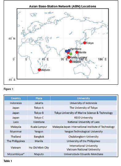
In order to help the countries in Asia to learn about GNSS and capacity development, we have been conducting seminars, workshops, trainings and joint research in various countries. We have installed survey-grade GNSS basestations in some of the universities in Asia. We call it Asian Base-Station Network (ABN). These base-stations provide data for research purpose as well as for local use of high-accuracy RTK survey. The list of the base-stations are shown in Figure 1 and Table 1.
One of the stations of ABN installed at Chulalongkorn University, Thailand is also connected to IGS network. The data can be downloaded from http:// www.igs.org/igsnetwork/network_ by_site.php?site=cuut. We welcome the readers interested in our ABN data to contact the author of this article for further details. We have already conducted trainings at some of the universities listed above. We have plan to conduct regular training courses in future as well.
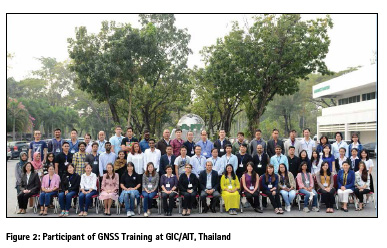
GNSS training
GNSS training is one of the effective approaches to develop required human resources in Asia. Trainings at various levels for various applications shall be conducted. In this regard, we have conducted a GNSS training at GIC (Geoinformatics Center), AIT (Asian Institute of Technology), Thailand in January 2018. This training program was jointly organized by GIC/AIT, UNOOSA/ICG (United Nations Office for Outer Space Affairs / International Committee on GNSS) and S4D/CSIS/ UT (Space for Development / Center for Spatial Information Science / The University of Tokyo). The objectives of the training programs are:
▪ Introduction to GNSS
▪ General overview of GNSS signal processing
▪ Introduction to PPP and RTK
▪ Field Survey using Low- Cost receiver for High- Accuracy positioning
There were 67 participants in the training program. 11 international participants were funded by ICG, 14 international participants were self-funded. The participants are from Afghanistan, Bangladesh, Bhutan, Cambodia, India, Indonesia, Japan, Maldives, Mongolia, Nepal, The Philippines, Sri Lanka, Tajikistan, Thailand and Vietnam.
This type of training is very effective to teach practical methods on how to process GNSS data for high-accuracy. Many participants have feeling that high-accuracy GPS receivers are very expensive so they don’t think about using GPS in other applications beyond surveying and mapping. Some participants thought that GPS was only for surveying, mapping and navigation. So they never thought about using it in agriculture, traffic analysis, timing applications etc.
The training materials can be downloaded from http://www. unoosa.org/oosa/en/ourwork/icg/ activities/2018/ait-gnss.html.
Training for policy and decision making level
GNSS being newer technology, it is also necessary to teach GNSS at policy and decision making level. In many Asian countries, use of GNSS is new application and its implementation requires decisions to be made at higher levels. Sometimes, these decisions are not made on time due to lack of technological information about GNSS. Thus, it is necessary to train and teach at policy and decision making level as well.
Education materials and tools
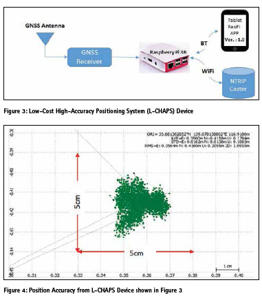
In order to provide practical exercise on use of GNSS, it is necessary to provide GNSS receivers to each student or trainee. However, a good GNSS receiver that can be used for high-accuracy (RTK) costs from a few thousand dollars to tens of thousands of dollar. It is not possible for an education or training institute in Asia to own multiple number of this type of GNSS receivers. Of course, it is necessary to have one or two units of high-end devices to analyze GNSS data. A low-cost GNSS receiver that is capable to provide high-accuracy (for RTK) is required for effective practical education.
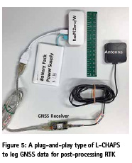
In order to solve this problem of receivers, we are developing low-cost high-accuracy GNSS receiver systems that are capable to provide raw data for RTK processing either in real-time or post-processing mode. Currently, this type of device can be made from GNSS module or receiver that can output raw data (pseudorange, carrier phase, SNR etc) by integrating with a board computer (RaspberryPi) instead of a computer. A prototype of this device is shown in Figure 3. The total cost of this device is below US $200- including GNSS receiver, antenna and RaspberryPi board computer. The receiver is capable of receiving signals from all GNSS systems in L1 band.
An Android APP is also developed to control the receiver and software in the board computer. RTKLIB software is installed in RaspberryPi to process GNSS signal for high-accuracy. All necessary signal processing and computations are done in RaspberryPi and the results are send to Android device via Bluetooth link for monitoring purpose.
The device can access NTRIP servers to get real-time RTCM data for RTK.
If the receiver only need to log GNSS data for high-accuracy position in postprocessing mode, a system based on RaspberryPi Zero as shown in Figure 6 can be used for lower cost and lower power consumption. This is a sort of plug-and-ply type of device. The device starts logging GNSS raw data necessary for RTK processing once power supply is provided to the board computer (RaspberryPi Zero with WiFi & BT.
Role of ICG
ICG (International Committee on GNSS) is playing a key role in capacity development in the field of GNSS. ICG has a working group “Information Dissemination and Capacity Building” to promote capacity development globally.
Please check the website at http:// www.unoosa.org/oosa/en/ourwork/ icg/working-groups/c.html to see the activities of service provider members from USA, Russia, Europe, China and Japan to promote capacity development. ICG also conducts many workshops around the globe to promote GNSS technology and capacity development. Please check their website at http://www.unoosa.org/oosa/ en/ourwork/icg/activities.html
Summary
In order to promote GNSS education and training in Asia, it is necessary to conduct regular trainings, workshops and seminars targeting various levels of users. This type of programs may be purely technical, non-technical or business oriented. It is also necessary to have a pool of resource persons who can teach and conduct trainings. In order to enable these activities, it is necessary to have good networking among the GNSS resource persons, users, system developers and integrators, various organizations involved in GNSS or related fields and funding agencies.


 (No Ratings Yet)


Leave your response!