| SDI | |
Geospatial Portal as an important SDI building block for Disaster Response and Recovery
International Centre for Integrated Mountain Development (ICIMOD) with its national and international partners has developed an Information Platform (Geospatial portal) to act as a unifi ed information hub and and a single-gateway for validated data and information related to the earthquake |
 |
|
Geospatial information systems provide the technology and tools to generate knowledge and added value in identifying problems and assessing alternative courses of action. Spatial data infrastructures (SDI) have evolved to address issues on coordinated development, access and use of geospatial information, and minimise resources wasted on duplication of efforts. The traditional view of mapping organisations being the sole producers and suppliers of geospatial information and users as passive recipients has changed with volunteered geospatial information where users also participate in information production.
Social media, crowdsourcing and mobile technologies have broken traditional barriers redefining how we work and share information from a local to global scale. It has also created new opportunities for collaboration in the development of SDI.
These technologies played an important role during the recent Nepal earthquake with the death toll reaching nearly 9,000 and approximately 2.8 million people displaced. In a disaster of this scale, help and support were urgently needed. There was a tremendous surge in the demand for information. Information poured in from social media and crowd sources, within and outside the country on damage assessments from satellite images, landslide mapping, road blocks, and base maps of affected districts.
While such efforts contributed to the disaster response, in many ways, they also revealed many gaps and associated challenges. Collecting, managing, processing, and disseminating timely and reliable information is key to emergency management and a multitude of recovery and reconstruction operations. To address this need, ICIMOD with its national and international partners, developed an information platform (geospatial portal) to act as a a single-gateway for validated data and information related to the earthquake. As the country moves forward from relief to the reconstruction phase, ICIMOD is working on extending the platform to tailor information needs with various analytical features. A unified platform with geospatial tools will greatly support the efforts of reconstruction by enabling judicious planning and decision making with regard to resource allocation and mobilisation and will help foster coordination among various actors on the ground.
Geospatial Portal as an Important SDI Building Block for Disaster Response and Recovery
SDI and disaster
Every year, natural hazards such as floods and landslides cause loss of life, property and infrastructure in Nepal. Hundreds lose their homes and means of livelihood. In recent years, there has been an increase in the frequency and magnitude of these events in the region mostly attributed to the impacts of climate change (ESCAP 2015; Gurung et. al. 2014; Thomas et. al. 2013).
The 25 April 2015 Nepal earthquake and 12 May 2015 major aftershock brought a long-feared destruction in the country to reality. With a death toll reaching close to 9,000, another 23,000 injured, and more than 785,000 homes damaged or destroyed, about 2.8 million people were displaced. In a disaster of this scale, the need for urgent help is tremendous and the demand for information rises exponentially. Critical information is needed to support a multitude of response operations – search and rescue missions, relief distribution, construction of temporary shelters, recovery of human casualties, damage assessment, mobilisation of volunteers, and coordination with multiple organisations both within and outside the country. Location information is crucial for these actions and the role of geospatial information and technologies for disaster management is well recognised. Timely, up-to-date and accurate spatial information describing the situation is of utmost importance for successful emergency response (Bhanumurthy et. al. 2008; Mansourian et.al. 2005; Rajabifard et. al. 2004). Logistics are critical to the efficient allocation and dispatch of relief operations. However, the availability and access to reliable, accurate and up-to-date information are major challenges in such situations.
The concept of spatial data infrastructure (SDI) evolved in the early nineties to address a lack of coordination in the development, access and use of geospatial information, and to prevent resources being wasted in the duplication of efforts. SDI encompasses a framework of technology, policies, standards, and human resources required for acquiring, processing, storing, disseminating, and effectively utilising geospatial information (Nebert, 2004). Spatial data resources play an important role in disaster decisionmaking increasing efficiency, providing a better method for communication and collaboration among emergency forces (Snoeren et. al. 2007). The dynamic nature of an emergency situation calls for timely information from various organisations. No individual agency can produce and update all of the required information. This calls for partnerships, data sharing and data exchange. Therefore SDI and its components can play a major role facilitating emergency management by providing secure, fast, reliable access to spatial data needed by emergency response workers (Rajabifard et. al. 2004; Snoeren et. al. 2007).
Evolutions in SDI
Development of SDI includes multiple actors, concerns, interests, points of view, and challenges. SDI has a dynamic nature due to the rate of technological advancement and changing user needs (Rajabifard et. al. 2006). The evolution of SDI has seen different approaches. In the product-based model, the main aim of an SDI initiative is to link existing and potential databases. In the process-based model, the emphasis is on facilitation through development of a knowledge sharing communication channel and capacity building. The composite product-process approach tries to balance the advantages drawn from both, enabling the SDI initiatives to be more versatile (Feeney et. al. 2001).
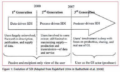
The traditional view of mapping organisations as the producers and suppliers of geospatial information and the users as the passive recipients of information is rapidly changing [figure 1] with the recent phenomenon of volunteered geographic information where the users also participate in information production (Budhathoki et.al. 2008).
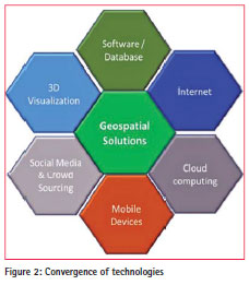
The emerging technologies of social media, crowd sourcing, cloud computing and mobile devices and their convergence [figure 2] have broken the traditional barriers of organisations, professional domains and geographic borders. The increasing use of these technologies is redefining how we work and share information from a local to global scale and has opened new opportunities for collaboration in SDI development. SDI can be realised at different levels (local, national, regional, global) and involves an array of stakeholders both within and across organisations including different levels of government, private sector and a multitude of users.
Social media and crowd sourcing during disasters
The strengths of social networks for information gathering during disasters are real-time recording and a proactive user approach. The ability to capture, communicate an event, a problem or an opinion enables users to contribute in a collaborative way speeding up the problem solving processes (Capineri et.al. 2015).
The ubiquitous smartphone with GPS and camera has enabled citizens to collect real-time data on-location and monitor events important to emergency management. Mobile phones can be used effectively in collecting data for relief operations and damage assessment.
The developments of Open Street Map, Google Earth and a variety of other webbased mapping services has enabled volunteers to directly assist in disaster response situations through mapping and other spatial analysis. Distributed mapping makes it possible to produce large number of maps within a very short time which is one of the greatest benefits to disaster management and was demonstrated during the Haitian Earthquake (Zook et. al. 2010). Volunteered geographic information is gaining increasing relevance as a source of information complementing authoritative spatial data and contributes in SDI development in areas with poor GIS data coverage (Goodchild, 2007).
The Nepal earthquake experience
Global geospatial community coming together
The Nepal Earthquake of 25 April demonstrated how the advances in Information and Communication Technology (ICT) have made it possible for the global community to come together during the catastrophic events. Seven minutes after the event, a red alert for international assistance was issued by the Global Disaster Alert and Coordination System (GDACS). The first reference maps were also produced on the same day in order to facilitate response efforts. The\ EU Copernicus Emergency Management Service\ was also activated on the same day and provided the first reference maps the day after (JRC 2015).
The US Geological Survey (USGS)\ compiled satellite imagery of the disaster area from different space agencies and made it accessible through its Hazard\ Data Distribution System (HDDS). In terms of satellite imagery, DigitalGlobe\ made the most significant contribution by making high resolution satellite imagery of the affected areas freely available online to all groups involved in the response effort. DigitalGlobe activated the subscription service FirstLook that provided emergency management and humanitarian workers with fast, web-based access to pre- and post-event images of the impacted area from its WorldView and GeoEye satellites (DigitalGlobe 2015). Many images were also made available by National Aeronautics and Space Administration\ (NASA), Canadian Space Agency (CSA), Japan Aerospace Exploration Agency (JAXA), Planet Lab, ImageSat International and Skybox Imaging (UN-SPIDER 2015).
The compilation in UN-SPIDER Knowledge Portal (UN-SPIDER 2015) shows that many crowdsourcing communities became active to support mapping needs for relief work. DigitalGlobe activated Tomnod, a crowdsourcing platform that allowed web-connected volunteers around the globe to help disaster response teams by mapping damage from the earthquake. The\ Tomnod website allowed users to participate in the Nepal campaign by tagging damaged buildings, roads, and areas of major destruction to inform disaster response teams on the ground. The Humanitarian Open Street Map Team (HOT OSM) mobilised 3679 mappers and made 62587 edits to the maps of the affected areas within five days of the earthquake. MicroMappers worked on analysis of images and text from tweets while MapAction worked on mapping of affected population. Humanity Road prepared situation reports including communities in need. Similarly United Nations Office for the Coordination of Humanitarian Affairs (UN-OCHA) implemented an information platform for the coordination of international humanitarian support and generated regular map products on the situation.
ICIMOD’s response efforts
Immediately after the earthquake, ICIMOD formed a team of GIS and remote sensing experts. While a lot of satellite images were getting available from different space agencies through the international charter, extracting meaningful information and delivering them to the government and other agencies were challenging. Responding to the requests from the Ministry of Home Affairs (MoHA), the ICIMOD team supported by a group of volunteers worked round the clock to process and analyse the latest satellite imagery for mapping pockets of settlements in affected districts and creating profiles of affected VDCs to inform relief operations. A large number of maps were printed and supplied to different agencies. Another team from ICIMOD set up an office at the airport to provide information to helicopter pilots and dispatchers, including Google Earth 3D images of flight routes to help pilots navigate unfamiliar terrain, identify and recognise destinations, and plan appropriate landing spots (ICIMOD 2015).
Landslides were another major obstacle to rescue and relief operations and there was an urgent need to assess the impact of landslides for immediate rescue efforts and monitor potential hazards. ICIMOD formed a task force on geo-hazards for monitoring landslides, glacier lakes, and river courses by analysing the latest satellite images and communicating the findings to the Government of Nepal and relief agencies. The task force coordinated with a broad international team including Chinese Academy of Science, NASA, the University of Arizona, USGS, USAID and JAXA.
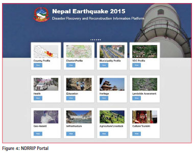
National Disaster Response and Recovery Platform (NDRRIP)
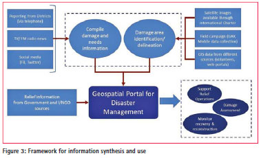
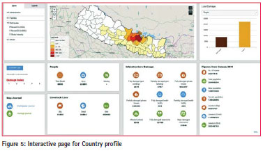
With numerous national and international agencies involved, it was felt that a comprehensive platform was needed where all information would be accessible and in a user-friendly interface. In collaboration with MoHA and technical support from Esri, ICIMOD deployed the Nepal Earthquake 2015: National Disaster Response and Recovery Information Platform (NDRRIP). The NDRRIP acts as a unified hub for earthquake-related information for use by government ministries and departments and other stakeholders engaged in disaster recovery and reconstruction. The framework of NDRRIP as a Geospatial Portal is illustrated in figure 3.
The portal provides key facts and figures at national, district, and VDC/municipality levels with interactive maps, charts, and infographics [figures 4 and 5]. Information is also provided under different thematic areas such as infrastructure, health, education, cultural heritage, agriculture, and geohazards. Story map journals for each affected district provide the status of casualties, damage, and response efforts. Other portal highlights are: an interactive before and after visualisations using high resolution satellite imagery; information on geohazards, including field data on landslides with 3D visualisation; and incident reporting for disaster events in near real-time through crowd sourcing.
Lessons for SDI
Challenges in generating useful information
Immediately after the event, there was a need for base maps to identify and locate affected areas and dispatch relief. Maps showing settlements and potential sites for helicopter landings were in high demand. The ICIMOD team was fully engaged compiling any available information from various sources including Google Earth. The gap on GIS base layers such as settlements, road networks, health facilities, open spaces and public utilities was seriously felt as they were either unavailable or were not up to date. Preparation of basic information layers needs to be given priority for disaster preparedness in future.
The availability of satellite images through on-line systems was unprecedented immediately after the Nepal earthquake. The international geospatial communities began preparing situation maps by using available imagery. Downloading large satellite images was impossible. The ICIMOD team worked with the NASA SERVIR Coordination Office in the US to reduce the size of images by tiling and resampling for file transfer. Many of the images were copied on hard drives and physically delivered. Basic infrastructures such as electricity and internet play a vital role during disasters, a necessity requiring proper emergency back up in the event of an emergency. Moving towards cloud computing for hosting of data and services can be strategic to develop economically efficient systems (Díaz et. al. 2012) which are also resilient to such disaster events.
High resolution images were helpful for visualisation of the affected areas but extracting useful information from these images for use in a GIS platform was a big challenge. There were technical issues on geometric corrections and overlaying with other data layers. Maps showing damaged building assessments using satellite images were prepared by many agencies. However, the usefulness was a concern as the detection of damaged buildings accurately was not possible except for those completely collapsed. Development of algorithms for semiautomated damage assessment should be a topic of research interest in the field of image analysis and interpretation.
Satellite images were most useful in the assessment of geo-hazards which included mapping landslides and monitoring glacial lakes.
Consolidating information from the ground
The HOT OSM community’s work in preparing the base maps of affected areas proved invaluable in generating value added products by other agencies. News on casualties and damages poured in from across the country. However, the information was aggregated at a district level and spatial details of damage were not available. Crowdsourced information on incidents and needs were limited to Kathmandu and were sporadic in nature. The trust and reliability of crowdsourced information has yet to be established for inclusion in government databases and response attention.
Many youth volunteers got organised to mobilise relief work and collect data on building and other damages. Various government departments and non-governmental organisations started campaigns for data collection from selected settlements and districts on their own, efforts that lacked any central coordination. The aspects of data storage, analysis and use seemed to be overlooked. Almost none of these campaigns considered geocoding of data while collecting them. Knowing who is doing what and where is important for logistical purposes.
Delivering the information
In addition to gaps in information collection and generation, delivery of accurate information to the users in the correct format is important. Paper maps were still the preferred format by the users going into the field making printing facilities crucial. On the other hand, the very dynamic nature of information updates during such disaster makes on-line portals most suitable. ICIMOD’s NDRRIP is one such effort to serve up-to-date information.
The Emergency Operation Centre of MoHA is the authoritative body for any disaster in the country. Current human resources and ICT infrastructure clearly need strengthening to deal with large disasters. Interaction with the IT team showed staff were overwhelmed with information requests as well as offers for assistance. Being the main hub for information flow from district offices, automated integration with the portal will make information dissemination more efficient. Without such a system in place, energy was spent digitising and storing data from many different sources and formats before serving on the NDRRIP.
Line agencies on utilities, roads, and health are producers and updaters of datasets everyday and during emergency situations (Rajabifard et. al. 2004). Adopting appropriate data standards and interoperability models by these agencies and data sharing will be a great support for disaster management. Geospatial portals can facilitate such inter-agency partnerships.
Moving towards reconstruction
As in any disaster event, attention from the international and national communities to the affected population slowly fades away with time and disaster management moves towards the phase of reconstruction. The information on damage and casualties become less dynamic and the demand for information slowly dies out. However, for reconstruction planning and management, more detailed information will be needed to deal with individual households. The issues related to relocation becomes even more complicated as it needs to consider economic, environmental and social aspects. Geospatial information becomes more relevant to analyse those different alternatives. Similarly, monitoring reconstruction activities and resources will be important in maintaining transparency of government interventions. The Geospatial Portal with appropriate geo-processing and query tools can fill this need to a great extent.
Conclusion
The 25 April Nepal earthquake resulted in a huge loss of life and was a major blow to the country’s economy. There was an immediate humanitarian response from the international community including the International Charter which provided a large volume of satellite information assistance in producing map products (UNSPIDER 2015). Extracting meaningful and effective information from these resources presented challenges due to technical infrastructure limitations. There was a need for better field data coordination, collection and application. Crowdsourcing has the potential to fill the gaps in spatial data and real time event reporting. There is a growing mass of young volunteers who can contribute to SDI in a collaborative way. Partnerships among all line agencies adopting interoperable data models are needed for best scenario disaster preparedness. This requires implementation of a functional SDI. The costs and benefits associated with SDI development is not clear (Masser 2015), however, the social benefits in assisting efficient emergency management will go way beyond economic benefits. Geospatial portals form essential components of SDI implementation by providing collaboration platforms for data sharing and access. The participation of multiple agencies will promote data quality and an adoption of standards. The NDRRIP was developed by ICIMOD to fill the gap of such a platform and to support earthquake response and recovery efforts. As the country recovers, ICIMOD is working on working on extending the platform to tailor information needs with various analytical features. It is hoped that such a unified platform with geospatial tools will improve reconstruction efforts by enabling judicious planning and decision making on resource allocation and mobilisation and will help foster coordination among various responders on the ground.
References
Bhanumurthy, V., Rao, G.S., Karnatak, H.C., Mamatha, S., Roy, P.S., Radhakrishnan, K. (2008) Emergency Management – A Geospatial Approach, in The International Archives of the Photogrammetry, Remote Sensing and Spatial Information Sciences. Vol. XXXVII. Part B4. Beijing.
Budhathoki, N.R., Bruce, B., Nedovic- Budic, Z. (2008) Reconceptualizing the role of the user of spatial data infrastructure, in GeoJournal, Vol. 72, No. 3/4, Volunteered geographgic information: key questions, concepts and methods to guide emerging research and practice (2008), pp. 149-160.
Capineri C, Calvino C, Romano A. (2015). Citizens and Institutions as Information Prosumers- The Case Study of Italian Municipalities on Twitter. International Journal of Spatial Data Infrastructures Research, Vol.10, 1-26.
Díaz, L., Remke, A., Kauppinen, T., Degbelo, A., Foerster, T., Stasch, C., Rieke, M., Schaeffer, B., Baranski, B., Bröring, A., Wytzisk, A. (2012) Future SDI – Impulses from Geoinformatics Research and IT Trends, International Journal of Spatial Data Infrastructures Research, Vol.7, 378-410.
DigitalGlobe (2015) DigitalGlobe opens access to satellite data to support disaster response efforts in Nepal, DigitalGlobe blog. http://www.digitalglobeblog. com/2015/04/26/digitalglobe-opensaccess- to-satellite-data-to-supportdisaster- response-efforts-in-nepal/
ESCAP (2015) Overview of Natural Disasters and their Impacts in Asia and the Pacific, 1970 – 2014, ESCAP Technical Paper, Information and Communications Technology and Disaster Risk Reduction Division, The United Nations Economic and Social Commission for Asia and the Pacific, Bangkok.
Feeney, M.E., Rajabifard, A., Williamson, I. (2001) Spatial Data Infrastructure Frameworks to Support Decision-Making for Sustainable Development, Paper presented at the GSDI-5, Cartagena de Indias
Goodchild, M.F. (2007) Citizens as sensors: the world of volunteered geography, GeoJournal, Volume 69, Issue 4, pp 211-221
Gurung, D.R., Shrestha, M., Shrestha, N., Debnath, B., Joshi, G., Bajracharya, R., Dhonju, H.K., Pradhan, S. (2014) Multi Scale Disaster Risk Reduction Systems, Space and Community Based Experiences over HKH Region, The International Archives of the Photogrammetry, Remote Sensing and Spatial Information Sciences, Volume XL-8, 2014 ISPRS Technical Commission VIII Symposium, 09 – 12 December 2014, Hyderabad, India.
ICIMOD (2015) Nepal Earthquake 2015 page. http://www.icimod.org/?q=17851
JRC (2015) Nepal earthquake: JRC supports EU’s response operations, JRC News 27 April, Joint Research Centre, European Commission. https://ec.europa. eu/jrc/en/news/nepal-earthquake-jrcsupports- eu-response-operations
Mansourian, A., Rajabifard, A., Zoej, M.J.V. (2015) Development of Web-Based GIS using SDI for Disaster Management, in Oosterom, P.V., Zlatanova, S., Fendel, E.M. (eds) Geo-Information for Disaster Management, Springer-Verlag.
Masser, I., Crompvoets, J. (2015) Building European Spatial Data Infrastructure, Third Edition, Esri Press, Redlands.
Nebert, D.D. (2004) Developing Spatial Data Infrastructures: The SDI Cookbook -2004. Global Spatial Data Infrastructure. Rajabifard, A., Binns, A., Masser, I., Williamson, I. (2006). The role of subnational government and the private sector in future spatial data infrastructures. International Journal of Geographical Information Science, 20 (7), 727-741.
Rajabifard, A., Mansourian, A., Williamson, I. P., Valadan Zoej, M. J. (2004) Developing Spatial Data Infrastructure to Facilitate Disaster Management, in Proceedings, GEOMATICS 83 Conference, Tehran, Iran. Snoeren, G., Zlatanova, S., Crompvoets, J., Scholten, H. (2007) Spatial Data Infrastructure for emergency management: the view of the users, Paper presented at the Third International Symposium on Gi4DM, Toronto.
Thomas, V., Albert, J.R.G, Perez, R.T. (2013) Climate-Related Disasters in Asia and the Pacific, ADB Economics Working Paper Series No. 358, Asian Development Bank, Manila.
UN-SPIDER (2015) UN- SPIDER Knowledge Portal http://www. un-spider.org/advisory-support/ emergency-support/9911/earthquakenepal- india-bangladesh-china
Zook, M., Graham, M., Shelton, T., Gorman, S. (2010) Volunteered Geographic Information and Crowdsourcing Disaster Relief: A Case Study of the Haitian Earthquake, World Medical & Health Policy Vol. 2: Iss. 2, Article 2.
The paper is prepared for presentation at FIG – ISPRS workshop, 2015: International Workshop on Role of Land Professionals and SDI in Disaster Risk Reduction: In the Context of Post 2015 Nepal Earthquake. Kathmandu, Nepal, 25th-27th November, 2015


 (2 votes, average: 2.00 out of 5)


Leave your response!