Articles in the SDI Category

NSDI in India runs the risk of losing its relevance.
That’s the reality and that’s the challenge.
The NSDI VI meet in Goa (see sidebar) was not able to rejuvenate the movement which is slumped by the feel of fatigue and frustration.
It was a high moment in the movement of NSDI when last year on June 13, the Government of India came out with a resolution on the constitution of NSDI.
The resolution established National Spatial Data Committee (NSDC) as an apex national authority for formulating and implementing appropriate policies, strategies and programmes for the establishment, operation, management of the NSDI and utilization and any other activities related to spatial data in the country.

I just wanted to congratulate you (and lead article author Mukund Rao) on the excellent wrap-up and exposition of India’s NSDI, NMP, status of OSM etc. in the July issue of Coordinates (http:// www.mycoordinates.org/cgi-bin// click.cgi?id=69). Very well done, especially the publication of both congratulatory and dissenting statements concerning NMP and the new Guide, from a wide range of stakeholders. Reviewing the statements and articles, as an outsider who has some familiarity with prior history of NSDI development in India, it would appear that the NMP is just the first step – and may still need lots of ‘fixing’ before it satisfies a much wider portion of the GI stakeholder community in India. This should surprise no one, given the scope of the policy and its potential impact on Indian society and economy.

The Government of India has formally approved the National Spatial Data Infrastructure (NSDI) programme – I told myself AT LONG LAST, IT IS DONE!!! I also heaved a sigh of relief – a sigh which has been weighing on my mind for the past 5 years (from February, 2001 onwards). In that sense of relief – that marked a feeling of achievement and success for the benefit of the country, I closed my eyes and …

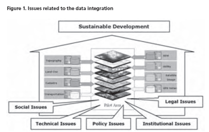
With applying modern technologies to generating spatial data, the amount of spatial data is increasing dramatically and huge amounts of data sets are being created and stored by different agencies.
Despite the growth of spatial datasets and the expansion of their use in different applications and new emerging services, they are being acquired and maintained by different organizations under different policies and even by organizations from different political and administrative levels. In such organizational arrangement, the spatial data providers produce and manage their own datasets without considering the reuse and integration of the datasets by other users, so most of the datasets have been produced and managed for a single purpose…

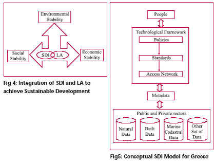
Spatial information plays important role in the development of the social, economic and environmental sectors. Some of the most remarkable applications for geographic information include: crime management, terrorism prevention, land and business development, flood mitigation, and disaster recovery (SDI Cookbook, 2004)…

The National Informatics Centre, Government of India is organizing NSDI-V during December 18- 21, 2005 at Hyderabad, India. On the occasion we present here the excerpts of recommendations of last four NSDI conferences. They, with the subsequent interviews, reveal moments of euphoria and despair, issues discussed and debated, and more importantly a resolve to pursue this dream.

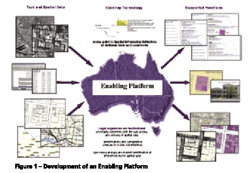
Users of positioning and spatial information services and tools require precise spatial information in realtime and real-world objects. Simply an accurate positioning of a future subdivision is no longer accepted, users require it to be visualized as well, in order to take into account outside in?uences. The capacity to meet such user needs and deliver services and tools within the spatial information market has gone beyond the ability of single organisations (Rajabifard, et al, 2005a). There is now a wide range of products and services available for a wide range of IT applications, and hence the development of an enabling platform can facilitate access to data and sharing resources and tools among different practitioners. The creation of an enabling platform for the delivery of these tools and positioning applications will allow users from diverse backgrounds to work together with current technologies to meet the dynamic market place.


 (5.00 out of 5)