| His Coordinates | |
By 2013, India will have a certified GAGAN
Says V P Agrawal, Chairman, Airports Authority of India |
|
In what specific areas of operation is AAI using the GPS technology today?
GPS Technology is used in AAI in the following areas:
a. Performance Based Navigation- Area Navigation COSPAS-SARSAT –Search and Rescue systems (satellite based)
b. Land Survey and Land Management
c. Preparation of Airport Maps and Charts – Cartography
Please tell us about some of the initiatives taken by AAI to improve Air Navigation Safety in recent years?
Augmentation of Communication, Navigation and Surveillance Systems for effective Air Traffic Management through implementation of state-of- the-art technologies, safety management systems and building up safety nets in ATM.
Communication:
• Automatic Message Handling System
• Integrated voice and data communication systems
• Controller Pilot Data Link Communications
• MODE-S communications
• Remote control Air ground (RCAG- connecting vast areas through VHF network
• Digital Automatic Terminal Information System (DATIS)
Navigation:
• Augmenting the Ground based Navigation system by installing additional DVOR/DMEs.
• Provision of Instrument Landing System (ILS) at majority of airports
• Implementation of Space Based Navigation System – GAGAN
• Implementation of Performance Based Navigation (PBN) procedures
• Implementation of Ground Based Augmentation System (GBAS)
Surveillance:
• Flight Data Processing System
• Surveillance Data Processing System including Safety nets
• Automatic Dependent Surveillance systems (ADS-C)
• Implementation of ADS-B (Broadcast)
• Radar Coverage over entire Continental Airspace by installing 9 additional Radars (MSSR) (Process in Progress)
• Provision of Terminal Approach Radars at busy airports
• Provision of ASMGCS at major international airports
The advancements in GNSS technology have made many of the earlier air traffic control systems redundant, please comment. What is the impact of the GNSS technology in AAI?
It is not true to generalise that the advancements in GNSS Technology have made many of the earlier ATC systems redundant. The existing Navigation systems are ground based and hence are having siting & range limitations. GNSS, being a space based system overcomes most of these limitations. Even after GNSS is fully implemented, the ground based systems may continue to exist as a fallback system in case of failures. As far as India is concerned, it is expected that by 2013, AAI will have a certified SBAS system named as GAGAN (GPS Aided GEO Augmented Navigation) in place. It may take some more years to achieve CAT1 status.
Which area of training is AAI focussing on for its personnel to meet the challenges of new technologies?
Training is always a top priority in AAI. The Civil Aviation Training College situated at Allahabad is an institution of international repute which takes care of the training requirements. As and when new equipments are inducted, our personnel get proper training from the respective manufacturers. Moreover, AAI encourages its personnel to participate in International Seminars, Workshops, and Exhibitions, etc to enrich their knowledge and keep themselves abreast of the latest technologies.
What kind of upgrades will be needed by the aircraft to match the new technology being implemented by AAI at the airports?
Most of the modern aircraft are fitted with appropriate avionics to meet the new technology being implemented by AAI.
| GAGAN: Final Operation Phase launched
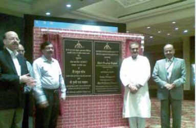
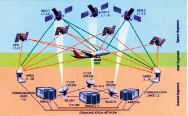
“With GAGAN, the air navigation in India is set to be redefined,” said Praful Patel, the Hon’ble Minister of Civil Aviation while launching the “Final Operation Phase” of GAGAN (GPS Aided Geo Augmented Navigation) in New Delhi on August 10, 2010. GAGAN is an ambitious project that Airports Authority of India (AAI) has embarked upon in a joint venture with Indian Space Research Organisation (ISRO). Mr Patel applauded the great work done by AAI and ISRO. He told that this step would not only benefit the country as a whole but also enhance India’s stature globally. He also emphasized the need to look at the commercial aspects of the project. On the occasion, Mr M M Nambiar, Secretary, Ministry of Civil Aviation, in his welcome address gave a glimpse of the work undertaken by the AAI in modernizing the airport infrastructure, be it terminal buildings or the CNS-ATM facilities/ procedure systems. He said that GAGAN would help to leapfrog in air navigation. Dr Nasim Zaidi Director General of Civil Aviation highlighted the significance of the GAGAN project. He mentioned the importance of the accuracy, integrity, reliability and continuity of the signals. In due course, we need to look at the legal regime in India and neighbouring countries in this context. GAGAN has been taken up with an objective to implement the SBAS technology over the Indian region. This joint project by AAI and ISRO aims to provide a seamless navigation facility in the region, which is interoperable with other SBAS. Although primarily GAGAN is expected to provide satellite based navigation for civil aviation across South and East Asia, and will provide India with the most accurate, flexible and efficient air navigation system deployed meant for civil aviation, it will also be beneficial for other users. AAI’s efforts towards implementation of operational SBAS can be viewed as the first step towards introduction of modern CNS/ATM system over Indian airspace. GAGAN will provide augmentation service for GPS over India, Bay of Bengal, South East Asia, and Middle East expanding upto Africa. The project involves establishment of a full complement of Satellite Based Augmentation System consisting of 15 Indian Reference Stations, 3 Indian Navigation Land Uplink Stations, 3 Indian Mission Control Centres, 3 Geo-stationary Navigation payload in C and L Bands and with all the associated software and communication links. |
What objectives were achieved for AAI in the ‘Technology Demonstration Phase Extended’ of GAGAN?
• GAGAN-TDS established the feasibility of an operational Space Based Augmentation System in the Indian Flight Information Region.
• The Final Systems Acceptance Test on August 12-14, 2007, demonstrated several of the key performance parameters of SBAS in India.
• The vertical and horizontal accuracy of the corrected position solution after processing by GAGAN—TDS and broadcast from the satellite was between 1 and 2 meters and is well within the 7.6 meter requirement for LPV approaches.
• The availability during the 24 hour FSAT test period of RNP 0.3 service, using just the eight Indian Reference Stations (INRES) of the TDS configuration was highly satisfactory.
• The LPV availability during the 24 hour FSAT test period, using baseline algorithms and just the eight Indian Reference Stations (INRES) of the TDS configuration was also satisfactory.
• It demonstrated the successful integration of ground element subsystems, communications network, and ultimately the space component. All parties to the project gained valuable insight into each other’s requirements, identified what practices work, and established confidence in the others.
GAGAN is still to achieve full functionality, in the meantime how is AAI managing the air traffic?
GAGAN is an upcoming system. AAI has a vast ground based CNS/ATM system which takes care of the present air traffic requirements. As explained earlier, many initiatives are in place to meet the Air Traffic Management requirements.
What improvements do you envisage in AAI’s functioning with the implementation of GAGAN?
With the implementation of GAGAN, the following benefits are likely to be achieved:
• Precision approach at all Runways
• Improved Efficiency/Economy because of:
º Direct Routes
º Increased Fuel savings
• Significant cost savings due to reduction of ground aids
• Reduced workload of Flight Crew and ATCOs
• Improved Capacity through reduced aircraft separation
• Higher Accuracy, Global Coverage
• Improved Safety
• Reduced Controlled Flight into Terrain (CFIT) incidents
• Enhanced Air-to-Air Surveillance: ADS-B
• Reduced Noise Pollution through implementation of continuous descent approach
Besides the financial, technical manpower and other supplementary support that AAI is providing to the GAGAN project; what are the changes that need to be effected within AAI to integrate its present activities with the GAGAN capabilities?
No additional changes will be required are needed to integrate GAGAN with systems of AAI.
GAGAN is dependent on GPS, how do you see the IRNSS fitting into the picture?
IRNSS is a regional set up compared to GPS which is a Global technology.
As ISRO is developing IRNSS it will be possible to integrate GAGAN with IRNSS at a later date.
What is your opinion about non-aviation market (ground users) for GAGAN?
GAGAN can be utilised by many other ground users for applications like:
• Surveying and mapping
• Ease of Search & Rescue operations
• Precision Farming including aerial spraying
• Precision Timing
• Navigation of Road and Sea transport
• Location based services like vehicle tracking system
• Mining And many more


 (No Ratings Yet)


Dear Sir
As bird strike is regarded worldwide as one of the worst aircraft hazards, could you tell me if the AAI deploys a range of advanced bird monitoring equipment to gather data and provide detailed reports on bird movements in Indian airspace or in the vicinity of an airport to assess the risks to aircraft from potential bird strike problems.
What are your views on bird management at your airports and is it an initiative for the AAI to employ more sophisticated and long term deterrents.
Do you employ experts in this field to advise of risk from migratory birds etc?
Leave your response!