NEWSBRIEFS –GIS
Jul 2008 | Comments Off on NEWSBRIEFS –GIS
|
|
|
|
|
|
| |
 |
|
|
Credent aids in Myanmar’s cyclone relief work
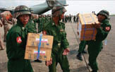
After NARGIS cyclone hit Myanmar and took the lives of about 100,000, an estimated 1.5 million victims are trying to survive in midst of chaos. Credent plans to extend assistance in the cyclone affected regions by providing the related map data from available resources including local organizations and the web. The development of the maps and GIS data is currently under Credent expense. To strengthen the provision of this vital information, any funding received will greatly improve the speed of the work. www.credent-asia.com/ |
|
|
The Hong Kong Lands Department chooses ESRI
Hong Kong Lands Department has awarded ESRI a US$4.9 million contract to replace its Computerized Land Information System (CLIS) containing digital map data by 450 users. ESRI will replace the CLIS with an enterprise GIS, allowing users throughout the department to work with one central geodatabase instead of disparate silos of data. It will better support the business processes and workflows of the department. www.esri.com
|
|
|
|
Compilation of a Carbon dioxide geological storage atlas
Carbon capture and storage (CCS) is one of the recognised mitigation measures for the lowering of greenhousegas emissions. Assessment of the potential for CCS in South Africa requires a detailed investigation into locating and characterising potential carbon geological-storage sites. The CGS, along with the Petroleum Agency of South Africa, has been appointed to compile and publish the resulting CO2 Geological Storage Atlas. http://196.33.85.14/cgs_inter/ |
|
|
NA VTE Q expands APAC coverage to Indonesia
NAVTEQ has announced release of navigable map coverage in Indonesia, which includes over 250,000 km of road network. The greater Jakarta includes areas of highest coverage level, inclusion and verification of up to 260 road attributes. www.gpsbusinessnews.com |
|
|
Tele Atlas to map the world in 3D
According to MD of APAC South for Tele Atlas, the company has deployed a fleet of camera-mounted vans canvassing the streets of major cities such as Singapore capturing 3-D information for its upcoming 3-D world maps. Each vehicle is equipped with up to six cameras capturing detailed information of its surroundings, including texture of building facades. It will be a couple of years before such capabilities come to the mass market. http://web20.telecomtv.com/ |
|
|
3-D modeling by Autodesk for better decision making
Easter Island is the most remote inhabited place in the world, more than 2200 km from the coast of Chile. As natural resources are being depleted at an alarming rate and tourism overwhelms the island’s fragile infrastructure, the island is at a turning point – trying to limit further damage to their historical sites. Autodesk offers 2D and 3D design technology – began work with the government in Oct 2007, they’ve been able to help digitally document historical artefacts, natural resources and infrastructure. 3D models of the island are helping to better visualize and analyze how development plans will impact residents and resources, and promote sustainable decision-making.
|
|
|
China Earthquake Geospatial Research Portal
The Harvard Centre for Geographic Analysis and Harvard Fairbank Centre for East Asian Research have established a China Earthquake Geospatial Research Portal. It contains maps, GIS data and GIS analysis aimed at assist ongoing research on the recent earthquakes in China.
The site hosts a map server for the sharing and visualisation of datasets relevant to the earthquake and its aftereffects. Two GIS vector layers are available for download – the earthquake epicentres and aftershocks and the illustration of the impact zones. |
|
|
Free GIS Services for earthquake relief in Sichuan Province
China TransInfo Technology has joined the Wenchuan Earthquake Enterprise Rescue Alliance headed by the ESRI, by providing free GIS services and products to the Sichuan earthquake relief effort. This Alliance has been providing real time information related to weather forecasting, transportation, electrical grids, and other areas in the disaster zone. www.earthtimes.org/ |
|
|
Coalition of Geospatial Organizations Formed in USA
Several national geospatial organizations have recently come together to create the Coalition of Geospatial Organizations (COGO). It was developed to provide a forum for organizations concerned with national geospatial issues that will 1) improve communications among the member organizations (and others), 2) provide educational information on relevant issues for their respective memberships, 3) align and strengthen their respective policy agendas, and 4) facilitate development of strategies to address national issues. The participants are
• American Congress on Surveying and Mapping
• American Society for Photogrammetry and Remote Sensing
• Association of American Geographers
• Cartography and Geographic Information Society
• Geospatial Information Technology Association
• GIS Certification Institute
• Management Association for Private Photogrammetric Surveyors
• National States Geographic Information Council
• University Consortium for Geographic Information Science
• Urban and Regional Information Systems Association |
|
|
Cadcorp announces new release of mSIS – mobile Spatial Information System.
Digital mapping and GIS software developer Cadcorp has announced a new release of its mSIS – mobile Spatial Information System (‘mSIS’) product. It is an easy-to-use field data capture application for the Pocket PC platform. It is supplied in two parts: a desktop based project management package – mSIS Office; plus the Pocket PC-based data capture software – mSIS Mobile.
Cadcorp is also looking for distributors in all territories. Those who are a systems integrator GIS developer, or an IT solutions company, can join the growing network of business partners from around the world. |
|
|
|
|
|
|
|
|
|
|


 (No Ratings Yet)


