| Mapping | |
When GPS empowers rural youth
|
Debapriya Dutta
|
||||||||||||
|
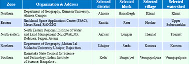
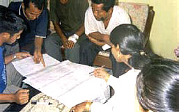
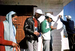
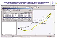
Nehru Yuva Kendra Sangathan (NYKS) , an autonomous agency under Ministry of Youth Affairs and Sports has the bounden duty to achieve the objectives laid down in the National Youth Policy. The advancement in the field of Science and Technology should be made available to the youth and to the community. As the adaptation of scientific and technological principles and developments, to maximize the use of local resources, are central to empowerment in the quality of life, the Policy recognizes the importance of emerging, modern technologies, particularly in the field of information technology and electronic media, in enabling the youth to perform and achieve in all sectors of their interest. Considering the emphasis on technological self-reliance and development and adaptation of suitable technologies for local needs to make an impact on the lives of ordinary citizens (Technology Policy statement, 1983), the Government of India initiated a number of technologybased programmes to support the Local level planning in1980s viz. Natural Resources Data Management System (NRDMS) of the Department of Science & Technology, National Natural Resources Management System (NNRMS) of the Department of Space (DOS) and Geographical Information System (GISNIC) and District Information System (DISNIC) of the National Informatics Center (Ministry of Communication and Information Technology). Recognizing the changing context of the scientific enterprise, and to meet present national needs in the new era of globalization, the Science and Technology Policy, 2003 reiterates to ensure that the message of science reaches every citizen of India, man and woman, young and old.So that we advance scientific temper, emerge as a progressive and enlightened society, and make it possible for all our people to participate fully in the development of science and technology and its application for human welfare. Indeed, science and technology should be fully integrated with all spheres of national activity. Considering the converging aims of the above policies, a collaborative programme ,“Empowering Youth through Geo- Informatics & Participation for Local Area Development (EYGIPLAD)” has been developed in collaboration between the NYKS and Natural Resource Data Management System (NRDMS) division of the Ministry of Science and Technology . The goal of the programme is to enable the youth to utilize the technologies of Geo-Informatics in local problem solving and build the capacity of the rural youth in modern technologies related to watershed management. i) Implementation MechanismThe project has been started as pilot in five locations in the northern, eastern, northeastern, western and southern zones of the country. For this purpose, five blocks in different zones of the country has been identified which have NRDMS activities, under Rashtriya Sadbhavana Yojna (RSY) programme of NYKS and having developmental priority of the District authority. A model village under NYKS has been selected under each block and a watershed lying in the selected village has been chosen for the programme. The selected districts, blocks, watersheds and identified technical groups in different zones are as follows: Household data collection The programme is being implemented in two phases: Field survey with Gps. The second phase focuses on the implementation of a small project by the volunteers at the identified blocks. MethodologyThe methodology adopted is as follows: DeliverablesFollowings are the expected deliverables: OutputsSome of the outputs are shown below; Route map prepared through GPS survey in almora A participatory mapping of the Theirait village, Lunglei. |
||||||||||||
|
||||||||||||
|


 (No Ratings Yet)


