| GNSS | |
WAAS Today
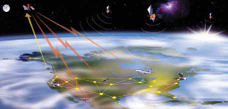
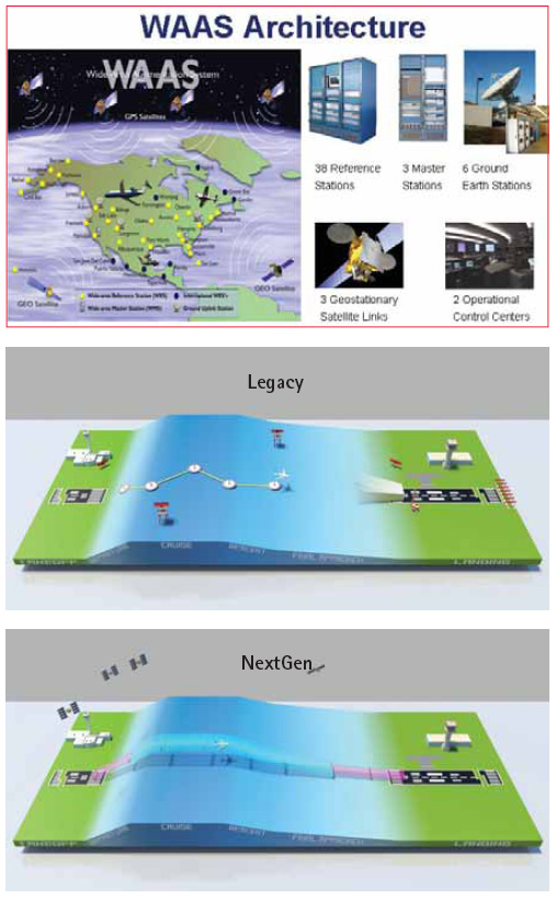
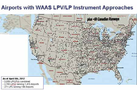
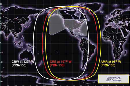
The role of WAASThe Wide Area Augmentation System (WAAS) was developed by the Federal Aviation Administration as an augmentation to the Global Positioning System (GPS). WAAS is needed because GPS alone does not meet the FAA’s navigation requirements for accuracy, integrity, and availability. In just one example, WAAS increases accuracy from 10-12 meters with GPS alone, to 1-2 meters horizontal. WAAS was developed to support navigation during all phases of flight – enroute through Category I precision approach. WAAS is also an important part of the FAA’s Next Generation Air Transportation System (NextGen) plans. As part of NextGen’s mission to meet the needs of U.S. National Airspace System (NAS) users, WAAS supports the FAA’s goal to transition from the use of ground-based navigation systems to those based on satellites. WAAS todayWAAS, which became operational in 2003, currently consists of 38 monitoring stations installed across the United States, Canada, and Mexico; three master stations; six ground earth stations serving three geostationary satellites; and two operations control stations. WAAS provides very precise navigation service, with both horizontal and vertical guidance over the Continental United States (CONUS) and a large portion of Alaska, Canada, and Mexico. Other countries and regions of the world also have fielded or are fielding similar systems. WAAS and each of these other systems are known as a Satellite Based Augmentation System, or SBAS. As envisioned at its inception, WAAS today provides service from enroute through approach. Because of WAAS, the FAA is starting to discontinue the service provided by older, ground-based navigation aids, such as VHF Omni-directional Ranges (VOR). Most of these systems are more than 20 years old. Replacing them would cost an estimated $1 billion. As of the spring of 2012, the FAA had 954 federally-owned and operated VORs (including VORTACs and VOR/DMEs). The FAA recently announced its plans to transition to a minimum operational network (MON) of roughly half of the current number of VORs by 2020. With WAAS in place, these older systems can be discontinued, thereby saving replacement costs while providing an improved level of navigation service. Unlike ILS approaches, WAAS LPV approach procedures do not require the installation or maintenance, both costly, of navigation systems at the airport. WAAS also enables another new type of approach procedure called Localizer Performance (LP). LP approaches are non-precision approaches, providing only lateral guidance, which is provided by WAAS. LPs are being published in locations where terrain or obstructions do not allow publication of vertically guided LPV procedures. LP procedures can often provide lower minima than the lateral navigation (LNAV) procedures which rely on ground-based navigation systems or on GPS alone. LPs will be published at locations where the terrain or obstructions do not allow publication of LPV procedures. In February of 2012, the FAA reached a major milestone when the number of published WAAS approach procedures available nationwide exceeded 3,000. By the summer of 2008, there were already more than twice as many WAAS approaches as Instrument Landing Systems (ILS) approaches. The FAA’s goal is to publish a LPV or LP approach procedure for every instrument runway in the U.S. Today, WAAS is providing the equivalent of precision approach capability at more than 1,400 airports throughout the United States, including about 2,800 runway ends. Who is using WAAS?To date, over 70,000 WAAS-capable receivers have been sold. This number is increasing at a rate of approximately 1,000 units per month. Current WAAS users can be found across many segments of the aviation community. The general aviation (GA) community was the first to support WAAS and continues to be strong proponent today, aggressively equipping with WAAS receivers that include LPV certification. Regional aircraft are also equipping with WAAS LPV capability in increasing numbers. There are over 2,100 regional aircraft equipped so far. Horizon Airlines, which equipped their Q-400s with WAAS, have increased poor weather operations. For Cape Air, another regional carrier, WAAS is helping to improve efficiency and enhance safety of their operations by providing more approaches with vertical guidance at numerous runways, including those with unique terrain challenges. The cargo carrier, Northern Air Cargo (NAC), was the first in the U.S. to equip a Boeing 737-200 aircraft with WAAS. For NAC, WAAS has enabled more direct flights paths than those provided by the current ground-based navigational systems, reducing fuel consumption, and providing environmental benefits. WAAS has also increased the rate of successful landings at remote Alaskan airports for NAC through the use of the lower WAAS approach minimums. Although originally developed for aviation, WAAS is now also popular for many other uses. When WAAS was first available, GPS manufacturers would sometimes add WAAS capability as a bonus. Today, it is rare to find a GPS chip manufacturer that does not include WAAS. WAAS is used by fisherman, boaters, farmers, and others that require precise positioning accuracy for the things that they do. More accurate than GPS alone, WAAS provides extremely accurate and reliable guidance when a mariner needs to get to a specific location – whether this is a fishing hole, a diving site, or an underwater object. Many marine manufacturers emphasize the availability of WAAS in specific products to appeal to their consumer base. WAAS also is popular for several uses within precision farming. WAAS allows farmers to plant their crops with high levels of accuracy and can help farmers more precisely administer the application of fertilizer and other materials to their fields. The popularity of WAAS in precision farming is evidenced by the presence of WAAS tutorials, WAAS status updates, and general WAAS information on websites dedicated to precision farming. In the field of mapping, post-processing was required for GPS data to be usable; with the greater accuracy of WAAS, there is often no need to post-process data. Even for more recreational uses, such as geocaching, WAAS is often considered a necessity. As an aviation agency, the FAA does not actively track non-aviation uses of WAAS, but it seems safe to say that anywhere there is a need for precise positioning; WAAS may be in use. What’s next for WAAS?To ensure WAAS continues to be a viable resource for the future, the FAA implements continued system development, sustainment, and technology refresh activities. WAAS is currently in Phase III of development, which includes activities to make WAAS compatible with the new GPS L5 frequency. This phase also includes the transition of WAAS operations and maintenance responsibilities from the WAAS prime contractor to the FAA’s WAAS Operations group. Phase III is scheduled for completion in 2013. Phase IV, the final phase of WAAS, begins in 2014. In Phase IV, the inclusion of GPS L5 – introduction of dual-frequency (L1 and L5) operations – into WAAS will be complete. The FAA plans to initiate WAAS Dual Frequency service in concert with the full L5 capable GPS constellation. (Two GPS satellites with L5 capabilities have already been launched and a full GPS constellation of L5 capable satellites is estimated to be available by approximately 2019.) The FAA will also continue to support the cur rent Single Frequency service. Phase IV will also include WAAS lifecycle maintenance activities and will continue until at least 2028. As part of sustainment and development activities, the FAA is committed to maintaining a robust constellation of geostationary satellites (GEOs). Today, WAAS uses three GEO satellites to broadcast the WAAS signal-in-space: the Intelsat Galaxy XV (also known as CRW); Anik F1R (a.k.a. CRE); and the Inmarsat I4F3 (a.k.a. AMR). The FAA is in the midst of acquiring leases on three additional GEOs. When these WAAS GEOs become operational, the use of existing (and older) GEOs will be discontinued. It is expected that all three new WAAS GEOs will be operational by 2018. The location of these new WAAS GEOs will optimize coverage and will also provide the ability to broadcast WAAS over dual frequencies. Beyond continued system development, sustainment, and technology refresh activities for WAAS; future WAAS initiatives include support of global interoperable SBAS services including the development of SBAS in South America, dual-frequency multi-constellation (DFMC) SBAS, and Advanced Receiver Autonomous Integrity Monitoring (ARAIM). In coordination with the SBAS Interoperability Working Group (IWG), the FAA is helping to draft operational concepts to support standards development for DFMC SBAS. The SBAS IWG is an international group comprised of SBAS service providers who meet on a regular basis to ensure seamless operations as systems expand, are enhanced, or as new SBAS systems are implemented. The IWG provides work products to the International Civil Aviation Organization, RTCA, and the European Organization for Civil Aviation Equipment (EUROCAE) to help guide the evolution of Standards and Recommended Practices (SARPs) and development of dualfrequency GNSS Minimum Operational Performance Standards (MOPS). Using the MOPS, the avionics industry can begin to manufacture dual-frequency GNSS avionics. ARAIM is another approach being investigated for using multiple frequencies to help resolve ionospheric delays. ARAIM uses ranging sources from two GNSS constellations to identify errors in both horizontal and vertical directions. ARAIM can identify errors smaller than those identified by traditional RAIM. In the future, ARAIM may be able to enable appropriately equipped aircraft to conduct precision approach operations based on minimally-validated constellation performance assumptions. Over the next two to three years, the FAA intends to clearly define how the ARAIM concept will work. With sufficient concept definition and maturity, standards development for ARAIM avionics can begin. Associated challenges include identifying threats, assessing algorithms, and determining the best way to inform aircraft of the validated constellation performance assumptions. As future initiatives progress, technical challenges, institutional challenges, or both are likely to present themselves. Continued collaboration with industry, academia, and international partners will provide benefit as the GNSS community moves forward together to meet future challenges. It will be exciting to see how WAAS and other GNSS systems continue to evolve over the next ten to fifteen years. For those interested in staying informed of WAAS activities, the FAA publishes a quarterly newsletter, SATNAV News, which can be accessed at http://gps.faa.gov
|


 (15 votes, average: 1.73 out of 5)


Leave your response!