|
The LEX PPP data with the IGS Ultra rapid data products have been compared to analyze the accuracy of LEX data
|
|
 |
C H Wickramasinghe
|
aGeoinformatics Center
|
Asian Institute of Technology,
|
Bangkok, Thailand
|
|
|
 |
L Samarakoon
|
aGeoinformatics Center,
|
Asian Institute of Technology,
|
Bangkok, Thailand
|
|
Errors associated with GPS observations make it impossible to use a single receiver for geodetic, geodynamic and vehicle automation applications requiring centimeter or millimeter level accuracy. Real Time Precise Point Positioning (RT PPP) has become a powerful tool that can provide positioning accuracy comparable to the network solution (Ge et al., 2007) without the need of GPS base station network. International GNSS service (IGS) has been providing data necessary for PPP via internet in real time. Quasi-Zenith Satellite System (QZSS) is a Japanese GPS augmentation system that also provides real time PPP correction through an experimental signal (LEX) from June 2011. LEX signal provides real time GPS satellite ephemeris and clock correction. The accuracy of these corrections data will directly affect the positioning accuracy (Zumberge et al., 1997). Through this paper we compared the LEX PPP data with the IGS Ultra rapid data products to analyze the accuracy of LEX data
Quasi-Zenith Satellite System (QZSS)
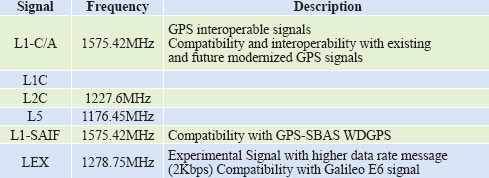
Quasi-Zenith Satellite System (QZSS) is a regional time transfer and GPS augmentation system covering the Asia pacific region mainly focusing on Japan. The first of the three QZS satellite that is needed to complete the consolation was launched on September 11, 2010. The path of the satellites has been designed with highly elliptical orbit to ensure that its orbit is at an elevation of more than 70° over Japan for a minimum of eight hours per day. This high elevation increases the availability of GPS satellites in urban cities in Japan. The system is designed to broadcast GPS L1C/A signal, L1C signal, L2C signal, L5 signal and two new signals L1-SAIF and LEX. L1-SAIF provides Wide Differential GPS (WDGPS) data which is only applicable for Japan. LEX is a new experimental signal broadcasting Precise Point Positioning (PPP) data. Table 1 contains signal specifications of QZS satellite. Eamonn P. (Glennon 2011) through his study has shown that QZSS signal design specification is very similar to that of GPS, which means that the effort needed to add QZSS capability to standard GPS receivers can be done with ease. The process should be easier for receivers tracking SABAS signals.
Table1: QZSS Signal specification (JAXA 2012)
QZSS LEX message
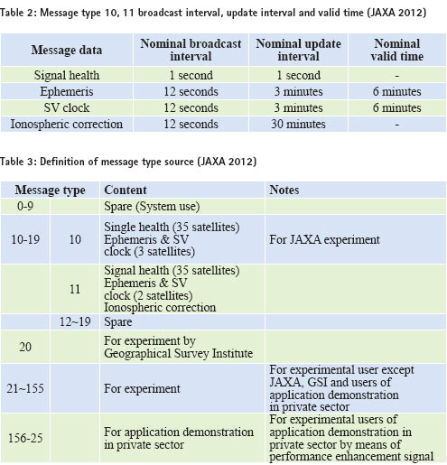
QZSS LEX signal is transmitted in 1278.75MHz as a new experimental signal through QZSS satellites. The signal is made up of different experimental messages and each one is made up of 2,000 bits: a 49-bit header, a 1695-bit data section and a 256-bit Reed-Solomon code. Transmission of the message takes one second. LEX signal doesn’t only contain PPP correction data, it also carries messages for other experiments and application demonstration in the private sector. For the PPP application only LEXMessage ID 10 and 11 are used. The 1,695-bit data section of message ID 10 includes the signal health and Ephemeris & SV clock data. Message ID 11 includes the signal health, Ephemeris & SV clock and ionosphere delay correction data. Table 2 contains the broadcast interval, update interval and the valid time of the data for Message 10 and 11. (JAXA 2012)
LEX signal decoding
LEX Message is Reed Solomon (255,223) encoded which enables to correct 32bit of error in the LEX Message. Each LEX Message signal is made up of a total of 2,000 bits; 49-bit header, 1695-bit data and 256-bit Reed-Solomon code. Figure 1 shows the flow chart of data extraction.

Figure 1. LEX data extraction flow chart
Each Message is identified with a Message ID, the Message IDs are given in Table 3 as defined by JAXA (JAXA 2012). The research work only focuses on satellite ephemeris and clock correction data, thus only message ID-10 and ID- 11 containing ephemeris, SV clocks and ionospheric correction were extracted. To extract the message ID-10 and message ID-11, individual 1744 bits has to be identified. According to Figure 2 data, bit packets were separated to three parts header, data part and the Reed- Solomon code. The preamble was checked for error caused during extracting the Message. The PRN was checked to see the broadcasting SV number. Message ID-10 contained ephemeris and clocks of three satellites and the message ID-11 contains ephemeris and clocks of two satellites and the ionospheric correction data.

Figure 2. LEX Message structure (JAXA 2012)
IGS products
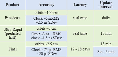
The International GNSS Services, (IGS) global system of satellite tracking stations, Data Centers, and Analysis Centers provides high-quality GPS data and data products on line in near real time to meet the objectives of a wide range of scientific and engineering applications and studies (IGS n.d.). IGS products contain satellite ephemeris and clock corrections with various temporal resolutions and accuracy. Final products are the most accurate with ~2.5cm ephemeris accuracy and ~75 ps RMS clock accuracy, but there is 12 – 18 days of latency. (IGS n.d.). As shown in Table 4, real time products have less accuracy compared to the final product. Jake Griffith and Jim Ray (Griffiths and Ray 2009) and (Urschl et al. 2005) have shown that the IGS data are accurate.
Table 4: IGS data products
PPP sensitivity analysis
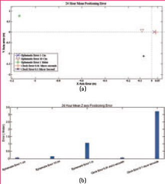
Figure 3: PPP positioning sensitivity analysis, comparing the effect on PPP positioning calculation with changing ephemeris and clock errors; (a) shows the 2D positioning error, (b) elevation error
To analyze how the accuracy of ephemeris data and clock correction data affect the PPP positioning, a sensitivity analysis was carried out using IGS Final Products data. Different scales of error values were introduced to the IGS Final Products data and position was recalculated with the changed data using 24 hours of observation. The mean positioning error values are shown in Figure 3. One centimeter error in ephemeris and 0.01 micro second of error had little impact on the positioning and nearly equal amount of error. But when it moves to 0.1 micro second of error in the clock correction, there is around 1m error in positioning in the Y axis, where as 10 cm in ephemeris only produced an error of 10 cm in position. Thus PPP is more sensitive to the clock correction data accuracy compared to the accuracy of the ephemeris data. Figure 3 (b) shows the error in the Z axis, which shows the error in clock correction has a high impact on the Z axis positioning. Thus accuracy of the clock correction will have more impact on PPP positioning accuracy compared to the improvement in the ephemeris.
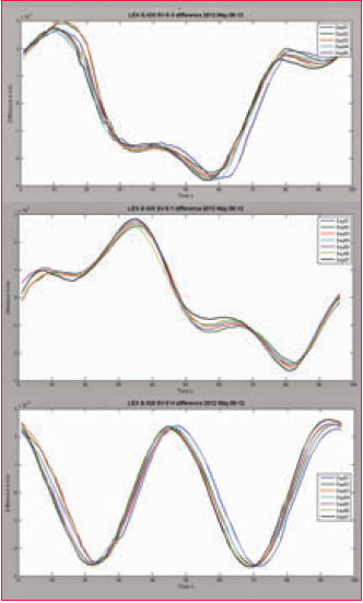
Figure 4. LEX Ephemeris error during second week of May 2012
LEX data analysis
LEX data showed high correlation in ephemeris, with the correlation coefficient around 0.98 in all X, Y and Z axis. High correlation in the ephemeris data doesn’t imply that the LEX data is accurate as IGS data; it says the data has the same characteristics and the same change in gradient in the data, thus the LEX data has accurate orbital path variation. However, clock error correction, correlation was below 0.3 showing that the LEX clocks correction data was not accurate. Accuracy of clock correction data is very important compared to satellite ephemeris data for real time PPP calculation as shown in the PPP sensitivity analysis. Table 5 shows correlation values for four selected satellites.
Table 5. LEX data correlation with IGS data

To further analyze the LEX data, satellite ephemeris errors were calculated taking IGS final product data as the benchmark, as IGS final product data have been proven centimeter level accuracy in the orbital data (Griffiths and Ray 2009). The errors were computed in 15 minutes intervals for a period of one week. It was found that the error in LEX ephemerides are partially systematic and, can be corrected to some extent by using modeling. But it’s not expected for the model to improve the ephemeris to centimeter level as it is difficult to model the changes in atmospheric drag, effect of solar radiation and effect of external bodies that can affect the stability of SV. The LEX ephemeris error varied from time to time from minimum of zero error to nearly 2.5 m of maximum error. Figure 4 shows the five-day error values in LEX signal for satellite SV 6. The error varies from +2.5 to -2.5. It also shows high correlation to the satellite orbital path of the satellite in each plane. All the satellites showed similar behavior for the entire week.
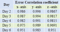
To find any relationship between daily errors, further analysis was done. Table 6 below shows the correlation coefficients of Day 1 (6th May 2012) in X, Y and Z axis LEX data error, with the rest of the week LEX data error for satellite SV 6. There is high correlation in all three axis throughout the week. The error is systematic and the high correlation proves that the error correction of the first day of the week can be applied to the rest of the week to improve the accuracy.
Table 6. LEX weekly error correlation for SV 6
Clock correction
Initial analysis of the LEX data showed that the LEX clock correction was a constant value which confirms the low correlation value of the LEX clock data with the IGS Final products data. Changes to the LEX clock correction was applied as a sudden step by changing the value by 1 microsecond to change the value as shown in Figure 6 diagram (b) and (h). Thus, the expected accuracy of the LEX clock correction is one microsecond. As for the IGS clock correction, there is a continuous change in the correction which is systematic and has an almost constant gradient. There are some points where the clock correction has sudden changes of the normal gradient. Figure 7 shows IGS clock correction data for the first three days of the week and the sixth day of the week for SV6. IGS Clock correction is decreasing with a constant gradient throughout the week. Analysis of all the satellites for a period of 7 days showed the clock correction gradually increasing or decreasing with time. This gradient can be predicted using the 1st order polynomial.
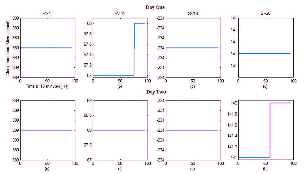
Figure 6: LEX SV Clock correction comparison on day one and day two
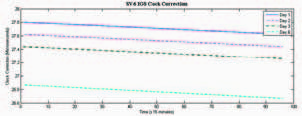
Figure 7: IGS SV 6 Clock Correction data for four days
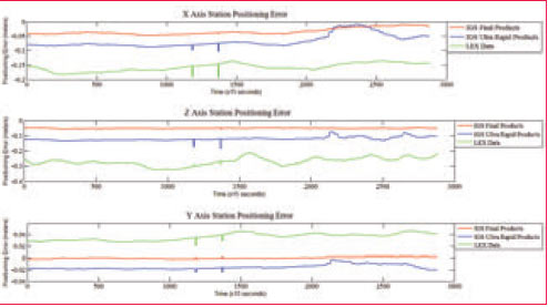
Figure 8: Positioning accuracy comparison of IGS Final Product, IGS Ultra Rapid Products and LEX PPP data sources.
Position accuracy
To evaluate the positioning accuracy of different PPP data, 24-hour of dual frequency observation from a well- established station was used. Real time LEX, IGS Ultra Rapid and post processed IGS Final products were used in this experiment. Figure 8 shows IGS final products were able to provide centimeter level accuracy with high precision. IGS Ultra Rapid data was able to keep the accuracy below 10 cm. On the other hand QZSS LEX based positioning accuracy was around 20 cm with relatively low precision compared to IGS-based PPP positioning. Figure 9 illustrates the 24 hours of positioning calculation using LEX and IGSUR data in 2D Cartesian plane. It shows 2D root mean square error of 0.108 m and 0.336 m and IGUR and LEX respectively, thus IGSUR data is able to provide around 10 cm of accuracy improvement compared to LEX in the 2D plane, for the height error IGSUR has a much higher accuracy with error of 5 cm compared to 30 cm error in the LEX data.
Table 7: Day 5 IGS Ultra Rapid and LEX Corrected positioning error results

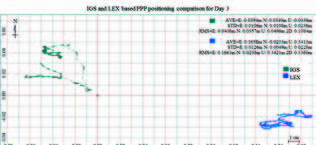
Figure 9: IGS & LEX based positioning results from real time data
Conclusion
It’s demonstrated through the research that IGS Ultra Rapid SV ephemeris and clock corrections are accurate compared to LEX data, thus for best real time positioning, the IGS Ultra Rapid data is the best solution currently available. On the other hand however, QZSS based PPP is not restricted by the limitation of GSM network such as coverage and weak signal as in the case of IGS data. Thus, QZSS PPP brings more possibility, such as real time PPP positioning in remote area such as mountains and even in the ocean. It will also help reduce data transfer between the base stations and GPS based monitoring sensors such as sea buoy, enabling the monitoring station to calculate its position accurately and transfer data when it is necessary. The result also shows the LEX data has ± 2.5 m errors in ephemeris data and its systematic repeating throughout the week can be improved to some extent. The satellite clock correction data provided by QZSS LEX data has only one microsecond accuracy. This is the major factor for low accuracy of QZSS PPP positioning. It’s suggested that QZSS LEX based positioning can be improved by using dense network of GPS base stations to improving the GPS satellites ephemeris and clock correction models as well as incorporating with the IGS data products.
References
Campaign, MGA-GNSS Demostration. multignss.asia. 6 10, 2012. http://www. multignss.asia (accessed 6 10, 2012). Ge, M., G. Gendt, M. Rothacher, C. Shi, and J. Liu. 2007. “Resolution of GPS Carrier-phase Ambiguities in Precise Point Positioning (PPP) with Daily Observations.” Journal of Geodesy 82 (7) (October 23): 389–399. doi:10.1007/s00190-007- 0187-4. http://www.springerlink.com/ index/10.1007/s00190-007-0187-4.
Griffiths, Jake, and Jim R. Ray. 2009. “On the Precision and Accuracy of IGS Orbits.” Journal of Geodesy 83 (3-4) (February 19): 277–287. doi:10.1007/s00190-008- 0237-6. http://www.springerlink.com/ index/10.1007/s00190-008-0237-6.
JAXA. 2012. Quasi-Zenith Satellite System Navigation Service Interface Specification for QZSS Japan Aerospace Exploration Agency. Aerospace.
Kouba, Jan. 2003. “A GUIDE TO USING INTERNATIONAL GPS SERVICE ( IGS ) PRODUCTS.” Jet Propulsion.
Urschl, C., W. Gurtner, U. Hugentobler, S. Schaer, and G. Beutler. 2005. “Validation of GNSS Orbits Using SLR Observations.” Advances in Space Research 36 (3) (January): 412–417. doi:10.1016/j. asr.2005.03.021. http://linkinghub.elsevier. com/retrieve/pii/S0273117705003029.
Wu, F, Nobuaki Kubo, and Akio Yasuda. 2002. “A Study on GPS Augmentation Using Japanese Quasi- Zenith Satellite System.” Science And Technology (November): 347–356.
IGS. igscb.jpl.nasa.gov. n.d. http:// igscb.jpl.nasa.gov/components/prods. html (accessed May 10, 2012).
Spofford, Paul R. “The National Geodetic Survey Standard GPS Format SP3.” IGSCB. 02 2, 2012. http:// igscb.jpl.nasa.gov/igscb/data/format/ sp3_docu.t (accessed 02 2, 2012).
Zumberge, J.F, M.B Hefline, w, M.W Watkins, and F.H Webb. “Precise point positioning for efficient and robust analysis of GPS data from large network.” Journal of Geophysical Research, 1997: 102(B3), 5005-5017. |


 (5.00 out of 5)


 (5.00 out of 5)


 (5.00 out of 5)


 (5.00 out of 5)
Leave your response!