| My News | |
Planning model for multiple hazard prone towns
This paper presents a planning model for hazard prone towns based on earthquake and flood damage assessment. |
|
Due to natural disasters like earthquake and flood the whole world suffers great losses; some towns vanish at one go and for all others it takes years and decades to resume the same state. To protect the existence of such hazard prone towns and minimize the losses it is important that planners frame some guidelines for the proper development of these towns which should be included in the master plan of these towns. For development of these towns a planning model based upon earthquake and flood damage assessment has been developed which can be utilized for other similar towns of the world.
Methodology
Following methodology has been utilized to achieve the above mentioned research objectives:

Case study
Earthquake and Flood Vulnerability of Madhya Pradesh
Madhya Pradesh which lies in the heart of India suffers mainly from two major hazards, namely floods and earthquakes. All earthquake activity is confined to Narmada-Son fault zone which runs across the State. The Earthquake Hazard Map of Madhya Pradesh with highlighted high-risk zone is shown in (Figure 2).

Hoshangabad is one of the towns, which comes very close to this high-risk zone. It is situated very close to two faults and hence close to a cross fault. The town is a district headquarter situated on the banks of the river Narmada. It is not only prone to earthquake but also flood. Geotechnically the town is settled on thick alluvium which is a very thick layer of sand mixed with clay and silt- which is not very compact and quite loose. This may increase the damage during minor earthquakes also. The other towns which come in this high risk zone are Jabalpur, Khandwa etc. Major institutions of the country like Geological survey of India, are working in this field. But for Hoshangabad town no study has been conducted till now.
Disaster history in the study area
The Hoshangabad town ship is very close to the active SONATA fault, which is the root cause for seismic activities in the region. The area falls under seismic zone III, which comes under moderate seismic risk region. The region has experienced 7 earthquakes in last 150 years, among which two had magnitude more than 6.
Flood is a frequent phenomenon in the study area. In last 80 years, more than 76 times, flood had inundated the lowlying area (Figure 3).

Floods in the study area are due to Narmada River and its tributaries. Data of last 80 years show that every year flooding is there up to certain extent but at least once in 10 years extreme flooding takes place.
Data collection
For detail analysis, 33 wards of the township which come under Municipal Corporation have been taken for study. The land use land cover of the city has been studied. The Municipal area covers 15,537 houses. To collect precise information about building stock distribution, a sample survey was conducted. In this regard, 5% buildings were surveyed and distribution was projected on the remaining building stock. The questionnaire developed for surveying the houses includes detailed information about material used for roof, wall and foundation, economic condition of house owner, configuration of buildings etc. The distribution of categories of houses in 33 wards of town has been taken as distribution shown in Census report 2002. The scenario has been developed only on building stock excluding other infrastructure. The Census of India 2001 has provided housing stock of the study area with special emphasis on type of material used in wall, floor and roofs.
Damage assessment criteria
The scenario has been developed on the basis of The Medvedev Sponheuer-Karnik (MSK) Scale of Intensity. Further the categorization is improvised using the Vulnerability Atlas of India. These are:
1. A Type Adobe, Field stonemasonry, Unburnt brick walls.
2. B Type Burnt Brick Houses.
3. C Type RCC and framed structure.
4. X Type Others (Light building material GI sheet, Asbestos sheets).
Earthquake damage scenario
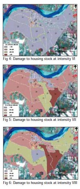
Based on experiences of past earthquakes, It is observed that A and B types are prone to damage at lower scale of intensity. The Hoshangabad town has 33 wards with population 97357. Based on the damage assessment criteria, survey results and 2001 census, damage Assessment at Intensity VI, VII & VIII for Hoshangabad Township has been calculated. At varying intensities the damage of total building stock is as given in Table 1.

At varying intensities the damage in different wards can be seen in Figure 4, Figure 5 and Figure 6.

As per the Earthquake Scenario, damage to houses may extend up to 73%. In view of such colossal damage, it is necessary to take immediate steps for earthquake safety of the area.
Flood damage scenario
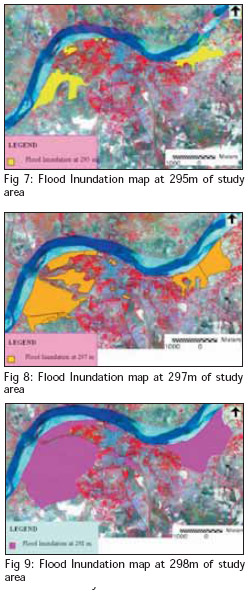
The damage Scenario changes with flood water levels. The increasing trend of damage is based directly on the increasing intensity of floodwater, which increases with flood levels. Looking at the historical flood levels recorded at Sethani Ghat, Hoshangabad of past 80 years, damage scenario for three most probable flood levels have been worked out with the help of survey results and flooding as observed through the years. At varying flood levels the areas which will be affected is as given in Table 2.

The various flood inundation areas at different flood levels have been represented in Figure 7, Figure 8 and Figure 9 respectively.

At varying flood levels the damage of Housing stock is as given in Table 3. The scenario has been developed only on housing stock excluding other infrastructure.

The approximate population likely to be affected at different flood levels are presented below in Table 4.

–~~~~~~~~~~~~–
Planning model
After analyzing the earthquake and flood damage scenarios, the following planning model has been proposed:
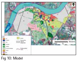
The town should be prepared for the worst possible scenario taken here which is the flood level of 978’ (298 m) which is considered to be most likely to occur. The areas which are likely to be worst affected at this scenario are shown in Figure 10.

Parks and play grounds, wood lands and gardens should be located here. The people should be discouraged to make houses in these wards which come under flood affected low lying areas. The wards which come under flood affected low lying areas as mentioned above, which have soil conditions including the level of water table favorable to liquefaction or settlements under earthquake vibrations will have greater risk to buildings and structures so the existing structures should be relocated in the south western part of the town.
In all other wards flood resistant houses should be constructed by raising plinth level of houses above average flood level for which special permission should be taken from the municipal corporation. The density of some wards in the old city area should be frozen to avoid further congestion and to avoid major losses in earthquake or flood event.
Phase wise retrofitting of all the housing stock should be undertaken. As per the Earthquake Scenario, damage to houses may extend up to 73%. In view of such colossal damage, it is necessary to take immediate steps for earthquake safety of the area. As the area falls under Moderate Seismic Risk Zone, all the construction should be as per earthquake resistant building construction codes.
By developing the existing corridors of the city, development of safer areas should be encouraged, which will reduce further congestion of the old city areas. Development in the south-eastern side of the town should be encouraged by providing basic infrastructural facilities like roads, street lights, and water supply etc., coupled with lower land prices in these areas.
The height of Lendia Nala Bund should be increased as well strengthened and completion of the Kishanpur Nala bund with flood protection gates and pumps. Boulder pitched bund should be provided along the river (Figure 10) and there should be proper maintenance of the boulder pitched bund besides the river.
Input in to the master plan
The above mentioned model is proposed as an input in to the master plan. Since Master Plan is constituted under the Madhya Pradesh Nagar Tatha Gram Nivesh Adhiniyam, 1973, for including these inputs in the master plan some amendments should be made in the relevant sections of the Master Plan.
Conclusion
There are many other towns in the region which are earthquake as well flood prone; the methodology can be utilized to make planning model for them too. All over the world many more areas and towns are facing the similar situations, the above mentioned methodology can be utilized to make planning model for them too, to minimize the expected losses from earthquake and flood.
As per the outcome of the research, further research should be done for proper preparedness and response during earthquakes and floods. Contingency plan should be made for all the flood-affected wards. This must have the details of role and responsibility of concerned officers and peoples representative of the community. The identification of volunteers and other support groups should be properly ensured. The resources inventory should be regularly updated and circulated within the response groups. The stocking of essential food, search and rescue equipments along with identified temporary shelters must be clearly identified and should be available for emergency uses. Relief camps should be established in the hospital school/ college buildings of the respective adjoining wards which are not or least affected or having large open spaces. The availability and location of resources required for search, rescue and relief should be well documented. The database preparation, their updating should be done at regular interval. Ward level road network should be demarcated on map. This helps in selecting the shortest rout during crisis time for relief work. The individual houses and structures with detail information should be marked on maps so as to work out the damage potential at micro level. All lifelines and infrastructures with their priority should be demarcated on the ward maps.
References
Acharya, S.K., Kayal, J., Roy, A. and Chaturvedi, R.K. (1998), ‘Jabalpur earthquake’, Journal of Geol. Soc. of India, 51, 295-304.
Arya A. S. (2000), ‘Recent developments toward earthquake risk reduction in India’, Current Science, 79.
BMPTC (Building Material & Technology Promotion Council., (2004), Building a New Techno-Legal Regime for Safer India, Ministry of Home Affairs National Disaster Management Division Government of India, New Delhi, India.
BMPTC (2002), Techno Legal Aspects of Earthquake, Windstorm and Flood Hazards and Land Use Zoning, Report of the Expert Group on Natural Disaster Prevention, Preparedness & Mitigation having bearing on Housing and related Infrastructure, Report Submitted to Ministry of Urban Affairs & Employment, Government of India.; New Delhi, India.
Burby Raymond J. (1998), Cooperating With Nature: Confronting Natural Hazards with Land Use Planning for Sustainable Communities, Joseph Henry Press; Washington, DC.
Chaturvedi R.K. (2000), ‘Seismotectonic evaluation of Son-Narmada Valley: Recommendations for future studies’, GSI Spl. Pub. 51, 197-204.
Earthquake Engineering Research Institute. (1999), Lessons Learned Over Time, Learning From Earthquake Series, Volume II, Innovative Earthquake Recovery in India, Oakland, California.
Fukuoka Shoji (1998), Floodplain Risk Management, A.A.Balkema. Rotterdam; Brookfield.
Geological Survey of India. (1998), Geological Map of India (1:2 million scale).
Geological Survey of India. (2000), Jabalpur Earthquake, A Geoscientific Study, Spl. Publication No. 51, India.
NCHSE (National Center for Human Settlement and Environment), (1995), Perspective Urbanization Plan for M. P.-2021, Bhopal.
NCPDP (National Centre for Peoples’ Action in Disaster Preparedness) for GSDMA (Gujarat State Disaster Management Authority), (2003), Capacity Building Program for Long-term Preparedness.
Sanderson David. (2000), ‘Cities, disasters and livelihoods’, Environment & Urbanization, 12, 2.
Scawthorn Charles. (2005), History of Risk Model Development, Kyoto University.
 |
|
|||||
 |
|
|||||
 |
|
My Coordinates |
EDITORIAL |
|
News |
INDUSTRY | GPS | GALILEO UPDATE | LBS | GIS | REMOTE SENSING |
|
Mark your calendar |
SEPTEMBER 2010 TO NOVEMBER 2011 |
Pages: 1 2


 (1 votes, average: 2.00 out of 5)


Leave your response!