NEWSBRIEFS –GPS
Jul 2008 | Comments Off on NEWSBRIEFS –GPS
|
|
|
|
|
|
|
 |
|
|
GPS system used to slow speeding cars
Cars will be fitted with test systems which tell drivers of speed limits and reduce vehicle speeds if they fail to slow down, as part of a new road safety trial in NSW, Australia. It will be a $1 million, 18-month trial involving 100 cars. The cars will be fitted with GPS devices. It will also warn drivers if they are speeding. In addition, 40 of the cars will be fitted with separate technology limiting fuel to the engine if a driver fails to slow down, automatically forcing a reduction in the car’s speed. http://news.theage.com.au |
|
|
GPS based Fleet Management by Oilfield construction firm
Pipeline construction firm Arnett and Burgess has selected the SmartFleet® GPS fleet management system for their fleet of light and heavy duty vehicles. It will provide online tools to help manage the safety of employees and the productivity of equipment. www.pr-usa.net
|
|
|
|
NYC makes buses hijack proof with remote controlled device
NYC has installed a new GPS device in thousands of local commuter and tourist buses. The device is attached to the bus computer system and it relays information about its speed and direction to a dispatcher. In the event of a hijacking, the dispatcher can remotely slow the bus down and prevent it from being restarted. Slowing the bus down is intended to give terrorists extra time to rethink their position before doing something drastic. http://gizmodo.com |
|
|
GPS clocks to maintain train punctuality
As many as 32 railway stations in between Tirupattur and Pothanur in the newly formed Salem division, India will soon have clocks that run on the GPS technology to maintain uniform train timing and punctuality. An estimated Rs 16 lakhs would be spent on the clocks. www.newindpress.com |
|
|
Lockheed Martin, Oz proceed with modernized train management
Australia is looking to GPS and inertial sensor technologies as the basis for a modernized train management system, using Lockheed Martin to help develop it. The company has received a US$74.8 million contract from the Australian Rail Track Corporation Ltd. for the proofof- concept phase of the Advanced Train Management System (ATMS). It will use inertial guidance technology and GPS tracking to feed train data such as location, speed, and weight to a central management system, which will in turn monitor train separations on the same sections of track. www.lockheedmartin.com |
|
|
IGNS Society announces new President
Matt Higgins was appointed the President of the International Global Navigation Satellite Systems (IGNSS) Society earlier this year. The IGNSS Society is a notfor- profit organisation supporting the Global Navigation Satellite Systems (GNSS) industry in Australia. Matt is an internationally recognised specialist in his field and was recently nominated as one of the 50 leaders to watch in the international global navigation industry by top industry publication GPS World. He also holds the prestigious position of vice president of the International Federation of Surveyors (FIG) from 2007 to 2010. In this position, Matt will represent FIG on the United Nations International Committee on Global Navigation Satellite Systems. |
|
|
Twenty-First Century Plant Hunter Survey UK National Trust Gardens
The UK’s biggest ever plant hunt began recently when gardeners and volunteers at Killerton in Devon kicked off a survey that will cover tens of thousands of plants at more than eighty significant National Trust gardens. A photo will be taken of each plant, a GPS grid reference will be recorded using the Magellan MobileMapper CX running DigiTerra Explorer 5 software and each plant will be identified by experts.
|
|
|
GPS failing? Blame it on Aurora Borealis
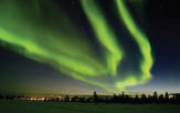
Scientists have discovered that the natural light shows of the Northern Lights – or Aurora Borealis – interfere with the signals from global positioning satellites, which are used by sat-navs to pinpoint the locations of vehicles, boats and aircraft. A study by the University of Bath’s department of electrical engineering is the first to find that the aurora borealis, which can be seen from most parts of Britain, directly affects sat-navs. The research, published in the American Geophysical Union’s International Journal of Space Weather, used three closely positioned sat-nav systems in Norway to measure the signal strength from satellites before, during and after an aurora borealis event.
They found the signal faded dramatically during the activity and the devices struggled to get a lock on the satellites. Under normal circumstances, the ionosphere, behave like a smooth plate of glass, allowing the signals from the satellites to pass straight through. But during the aurora, the ionosphere becomes “lumpy”, which disrupts the signals. Prof Cathryn Mitchell, who led the research, said sat-nav errors were likely to become more frequent over the next four years due to increasing aurora activity. “Anywhere that the aurora is visible, it will cause disruption,” she said. “Although most people in the UK can’t see the aurora when it is happening, because of cloud or ambient light, it can still affect the GPS signal. We have just passed a minimum in activity but we are due to hit a maximum in 2012, which is wh we would expect to see most disruption.” The last peak in aurora activity came in 2000, when few GPS devices were in use. |
|
|
|
|
|
|
|
|
|
|


 (No Ratings Yet)


