| GNSS | |
National GPS programme for earthquake hazard assessment
|
|||||||||||||||
| The GPS technology is being used extensively all over the world to generate useful data for different purposes. The Department of Science
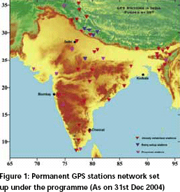
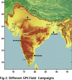
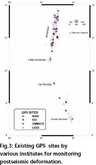
and Technology, Government of India has evolved a programme on GPS to study crustal deformation processes with the following objectives : i. To establish the rate of movement of the tectonic plates relative to each other. ii. To establish the strain rates in different tectonic domains of India and to constrain strain partitioning in discrete tectonic domains/ blocks and identify the area of higher strain build up/ release. Participating organisations• Survey of India, Dehradun • CSIR Centre for Mathematical Modeling and Computer Simulation, Bangalore (CMMACS). • Wadia Institute of Himalayan Geology, Dehradun (WIHG) • Indian Institute of Technology, Mumbai (IITM) • Indian Institute of Technology, Kanpur (IITK) • Indian Institute of Geomagnetism, Mumbai (IIG) • Centre for Earth Science Studies, Trivandrum (CESS) • G B Pant Institute of Himalayan Ecology & Development, Almorah (GBPIHED) • National Geophysical Research Institute, Hyderabad (NGRI) • India Meteorological Department (IMD), New Delhi • GND University, Amritsar • Cochin University, Cochin • Indian Institute of Astrophyiscs, Bangalore (IIA) • Geological Survey of India (GSI) • Tezpur University, Tezpur • Mizoram University, Aizawl • Manipur University, Imphal • Nagaland University, Kohima • Gauwahati University, Gauwahati • M S University, Vadodora • Regional Research Laboratory, Bhopal Status and achievementsThe implementation of the National GPS Programme for Earthquake Hazard Assessment, as recommended by the GPS Expert Group, has been taken up by the DST since 1998. An extensive network of permanent, semi-permanent and field GPS stations is being established by the participating organizations, and a National GPS data centre has been established at Survey of India (SoI), Dehradun. Specifications of the GPS instrumentation for this purpose have also been formulated. A Committee has been constituted for overseeing the programme. A brief report on these activities is given below: Establishment of permanent stationsSo far, the DST has set up 35 Permanent GPS Stations all over the country in collaboration with Scientific organizations and Universities . Necessary efforts are also being put to set up few more permanent stations . Recently a permanent station has been set up at Portblair with the help of NGRI, Hyderabad and India Meterological Department. It is also proposed to set up few permanent stations in Gujarat and Rajasthan area since very few permanent stations are available in these areas. Met packages are being installed at some permanent GPS stations to facilitate the above studies and optimize the scientific outcome. National GPS Data CentreConsidering the importance of management of a huge volume of GPS data collected from different GPS-related projects, a National GPS Data Centre has been set up at Survey of India, Dehradun. Continuous GPS data from all the permanent stations as mentioned above are being sent to the data center at SoI. The SoI is also planning to make the data available to all authorized users through ftp/ internet, so as to reduce response time for data delivery and eliminate avoidable manpower costs. Transformation ParametersThe reference frame for GPS is World Geodetic System-1984 (WGS-84). GPS measurement at terrestrial sites therefore give coordinates on WGS- 84 Datum. This datum is different from that of the Indian Geodetic datum i.e., Everest Datum. All SoI topographical maps are based on this datum. In order to make optimum use of GPS-based coordinate system, it has become essential to determine transformation parameters for conversion of coordinate of points from WGS-84 Datum to Everest Datum, and vice versa. In view of the importance of this task, DST had sanctioned a project entitled “Determination of Transformation Parameters between Everest Datum and World Geodetic System-1984 (WGS-84 Datum)” to the SoI. The SoI has already completed GPS measurements at 272 old GT stations for this purpose. The transformation parameters between WGS-84 and Everest datum have been successfully determined for the entire country including Lakshadweep and Andaman & Nicober Islands, except for the state of Jammu and Kashmir region due to insurgency problem. The SoI is planning to carry out GPS observation in Jammu and Kashmir with the help of Military. Crustal deformation studiesThe 26th December 2004, earthquake was the biggest event in Indian history that killed thousands of people by creating a big Tsunami. It was also the largest Seismic event to strike in the era of modern GPS Technology. The recent findings of the GPS data indicate that the area of 4500 km-radius experienced clearly measurable surface displacements. Just immediate after the earthquake, few pilot projects were supported for carrying out GPS observations in the Andaman & Nicobar Islands. The SoI, (Dehradun), NGRI (Hyderabad), CMMACS ( Bangalore) and CESS (Trivandrum) carried out some campaign mode studies in Andaman and Nicobar Islands. GPS measurements by Survey of India during March 2004 and January 2005 at twelve sites in the Andaman- Nicobar Islands which provided a comprehensive and reliable estimates of coseismic movements, slip on rupture and rupture characteristics of 26 December 2004 giant Sumatra earthquake. It has been reported by NGRI, Hyderabad that there was a coseismic horizontal ground displacement of 1.5-5.0 m in the SW to WSW direction in Andaman Islands, 4.0-6.5 m in SW direction in Nicobar Islands, coseismic uplift of 0.5-1.0 m in the North Andaman Island, subsidence of less than 1 m in Middle, South and Little Andaman Islands and subsidence of 1.1-2.8 m in Nicobar Islands occurred. Recently, a permanent GPS station has been set up at Port Blair to continuously monitor the movement of the Andaman and Nicober Island. Similar results have also been reported by CMMACS (Bangalore) and CESS (Trivandrum) Manpower developmentConsidering the need of suitable manpower in GPS technology, efforts are made by the Seismology Division, DST to organize short term courses, workshops and training programmes. As a result of this, 5 training programmes/short term courses have already been organized at WIHG Dehradun, IIT Bombay, and CMMACS Bangalore in which nearly 100 persons from various Universities and research institutes have been trained. AcknowledgementsAuthor is thankful to all the participating organizations who are actively involved in DST projects for providing required information in respect of their projects. |
|||||||||||||||
|
|||||||||||||||
|


 (No Ratings Yet)


