| Mapping | |
Large scale topographical mapping for Republic of Maldives
|
|||||||||||||||||||||||||||||||||||||||||||||||||||||||||
|
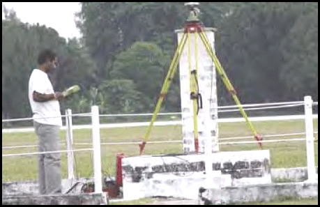
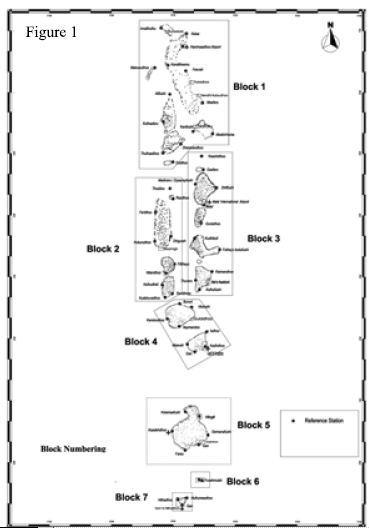
The Republic of Maldives is an archipelago (group of Islands) in the Indian ocean with 1190 islands few of which are inhabited and many are uninhabited Islands. The islands are grouped in the form of atolls. An atoll is a coral island consisting of a circular belt of corals enclosing a central lagoon and Maldives consists of 25 atolls. The land portion is around 300 Sq. Km. out of 100,000 Sq. Km. while the rest of the area is covered by water. The basic objective of the project is to prepare Large scale topographic maps of different islands of Maldives. National Remote Sensing Agency (NRSA) was entrusted this task as part of a Memorandum of Understanding between Ministry of External Affairs, Government of India and the Ministry of Planning and National Development, Republic of Maldives. Many organizations and fi rms tried in the past to carry out this task and they were unsuccessful. NRSA carried out aerial photography at 1:40000 scale to map the entire Republic of Maldives at 1:25000, sixteen selected islands are fl own at 1:6000 to map in 1:1000 scale and a reference datum for Maldives in WGS-84 is established for the first time. Project ObjectivesThe major objectives of the large scale topographic mapping project for Maldives are 1. Establishment of a reference network in WGS- 84 datum using GPS. 2. Preparation of digital maps of entire Maldives on 1:25000 Scale. 3. To prepare large scale digital maps on 1:1000 scale for sixteen selected islands. The following methodology was adopted for this project and each and every stage of the project is explained in detail. Reference network in WGS-84 DatumThirteen reference stations spread over the entire country were identifi ed and monumented to establish a reference network for Maldives. The map of Maldives was divided into seven blocks for planning and execution of this task as shown in fi g.1. The georeferenced IRS-1D LISS-III satellite images were mosaiced seamlessly for contiguity and proper planning of photo target points and GPS reference stations. The reference stations were located in such a way that at least one reference station is there in one-degree grid. Each reference station was occupied with geodetic grade dual frequency GPS receivers for a minimum of three days for duration of 12 hours from 6AM to 6PM every day. The Male IGS station was also occupied as part of this GPS campaign. The GPS data was processed in a scientifi c post processing software Bernese, which is capable of processing long GPS baselines and the coordinates of the reference stations were computed using the data from the nearest IGS stations. Thus a reference network of thirteen reference stations for Maldives was established. Aerial PhotographyThe Republic of Maldives extends from 1°S to 7° N Latitude and 72° to 74° E Longitude approximately. Since the majority of the area is covered by water, effective fl ight planning was a important and critical component for this project. Information from satellite images, existing atlas maps, old maps etc., were used to prepare optimized fl ight plans so as to make fl ying economical and minimize wastages. A mosaic image of the Republic of Maldives was prepared using IRS- 1D LISS-III satellite data comprising 23 scenes and the mosaic was used in the fl ight planning for the entire Maldives, this has ensured that no island is missed for aerial photography. The fl ight plans were generated using World Wide Mission Planning (WWMP) software and the preplanned exposure coordinates were incorporated in the Computer Controlled Navigation System (CCNS). Aerial photography (Black & white) was carried out using Beechcraft Super King Air B- 200 mounted with Zeiss RMK 15/23 metric camera and integrated with INS and Kinematic GPS. The aircraft is guided by Computer Controlled Navigation System (CCNS) software for carrying out aerial photography very accurately. The camera is tightly coupled with CCNS which in turn connected to airborne GPS. The scale of mapping using 1: 40,000-scale aerial photograph is 1: 25,000 scale for entire Maldives and sixteen selected islands were mapped at 1:1000 scale using aerial photographs of 1:6000. The GPS reference stations thirteen in number were also used as reference stations for the airborne GPS assisted aerial photography of Maldives. The exposure station coordinates were computed by differentially processing the airborne GPS data with reference to reference station GPS data using GPSurvey software. Ground Control PointsForty two Pre-target Ground control points spread over the entire country were established for carrying out mapping at 1:25000 scale. The pretargets are 3m X 3m in dimension with plus mark in Black and remaining area in white. Each pre-target was occupied with a geodetic grade GPS receiver for a duration of 3 hours and the data was processed differentially with reference to the reference station identifi ed as part of datum establishment using SKIPRO software. The establishment of GPS reference stations, airborne GPS assisted aerial photography and occupation of pretargets were taken up during the same period so that reoccupation of the reference stations could be avoided. The GCPs for mapping sixteen selected islands, separate GPS survey was carried out by selecting suitable control points on ground and corresponding nearby reference stations were occupied simultaneously to differentially process data and to determine the control point coordinates. Aero Triangulation and Block AdjustmentThe B/W film was developed in the photo laboratory at NRSA and negative rolls were scanned using high precision photogrammetric scanner i.e., Zeiss SCAI and the scanned images were used for further processing on digital photogrammetric workstations. The Automatic Point Matching (APM) module was used to generate pass & tie points. The aero triangulation was carried out using SOCET SET Photogrammetric software and bundle block adjustment was done with ORIMA block adjustment software. The aero triangulation and block adjustment step was very crucial and was done in a systematic manner since APM in this type of terrain is very difficult because most of the area is covered with water and he land portion with features is minimal. Mapping of the IslandsThe vector data model for mapping the Islands of Maldives were developed, it includes layerization, line types, point symbols, hatch patterns, text fonts, mockup etc. The digital vector capture was done using Microstation/ AutoCAD mapping software which was interfaced to digital photogrammetry workstations. The digital data is in AUTOCADD format and were imported to ARCGIS environment for further analysis. Field Verification, Field data collection & Hardcopy PlotsThe field verifi cation and field data collection at different islands of Maldives were carried out using 4X enlargements of the aerial photographs and vector plots of each island. The field data, corrections and annotations have been incorporated in the final digital maps. The map composition or mockup for different scales has been prepared and hardcopy plots have been generated. Quality Assurance/ Quality ControlThe quality of the data has been checked at each and every step so that the data meets international standards. The vector data capture process was checked at three different stages one at the time of progress of the work and was it was carried out online, the second online total quality control at the end of vector capture process and at third stage the hard copy QC after the incorporation of the field data was done. The QA/QC was done to check the data in all aspects like interpretation, categorization, completeness, consistency in height information, layerization, symbology, topological aspects, GIS compatibility, annotation in terms of font and style, hatch patterns, mockup, orientation of textual information etc., of the data. Mapping SchemaA mapping schema for the 1:1000 and 1:25000 scale maps prepared for the Republic of Maldives was developed at NRSA. The projection is in modifi ed Universal Transverse Mercator (UTM) and the spheroid is WGS-84. ConclusionsNRSA has carried out mapping of entire Maldives at 1:25000 and sixteen selected islands at 1:1000 scale for the first time in the history of Maldives. Many organizations and fi rms tried in the past to map the Republic of Maldives and they ended in failures. The highlights of the project are 1. Establishment of a reference network in WGS-84 datum for Maldives. 2. Pre-targets & KGPS were effectively implemented. 3. Aerotraingulation for atolls, which is a group of scattered islands, was a very diffi cult task. We have gained valuable techniques and knowledge to carry out aerotriangulation and block adjustment for a diffi cult terrain. 4. Mapping numerous tiny islands and its environs was a unique mapping experience. NRSA due to its vast experience in the area of mapping, took this task as a challenge, planned and executed each and every step carefully in a systematic manner and successfully completed the project in time. |
|||||||||||||||||||||||||||||||||||||||||||||||||||||||||
Aerial Services and Digital Mapping Area, National Remote Sensing Agency, Department of Space, Government of India |
|||||||||||||||||||||||||||||||||||||||||||||||||||||||||
|


 (No Ratings Yet)


