| Navigation | |
Indian electronic navigational charts : A digital journey
|
|||||||||||||||
|
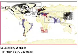
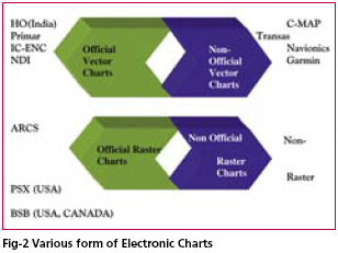
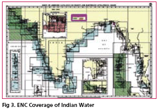
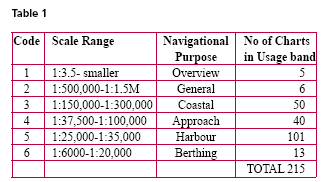
The Basic role of a Hydrographic Office’s (HO) is to provide essential hydrographic Services to support safe and efficient navigation and promote national maritime development for the nation. In recent years HOs all over the world are playing leading role in development of Electronic Navigational Charts for marine community so that vessels can navigate safely on their voyage across oceans. Navigation of ships in and out of the nation’s coastal waters and channels could be made safer by improving the Navigational systems by adopting new navigation technologies. In recent years, -publicized shipping disasters have called into question the safety of life at sea both to the mariners and ocean environment, the effectiveness of navigation technology thus is facing challenges and looking into future for a technology that the Navigation system uses. Presently although Navigational systems for the most part are safe, but could be made more safer with improvements in onboard navigational systems performance by better use of new technologies including improved coordination of vessel traffic and using digital/electronic navigational charts for improved safety. Innovations in navigation technology hold significant potential for reducing operational risk and improving safety performance, and their introduction should be expedited. Use of Electronic Chart Display and Information Systems (ECDIS) to replace paper charts holds particular promise. When combined with data from Global Positioning System, satellites, electronic charting systems can provide accurate real-time positions, as well as steering guidance, automatic hazard warnings, and a permanent navigation record. However, the full benefits of this and other new technologies are not likely to be gained in the near term unless deliberate measures are taken to promote their introduction. A comprehensive & specific familiarization for use of the ECDIS should be made before implementing this new navigation technology. Such measures must include establishment of technical and operating standards and improvement in charting of water depths and other hydrographic data. Professional training in the use of these new technologies is essential. The international nature of the shipping and maritime industry is well known,therefore in order to improve standards and to recognized the actions required to improve safety in maritime operations would require more efforts at an international level rather than by individual countries acting unilaterally and without coordination with others. With this aim it was decided that Electronic Navigational Charting is such a source that would increase safety of navigation and facilitate everyday mariner’s work. First electronic charts and related systems had appeared on the market in early 80s. These charts were merely scanned and digitized paper chart reproductions-so called raster electronic charts. The quality and contents of nautical charts is the cornerstone of safety at sea, and is strictly controlled by international agreements. Thus the industrial development of technically elegant solutions is not enough, the products must meet a well-defined standard for international approval of IMO/ IHO. As a result an international S- 57 standard has been established. Worldwide ENC coverageThe lack of comprehensive ENC coverage along major shipping routes has been significant and also there was confusion about policies regulating the use of ENC and paper chart, furthermore, uncertainty was also about using SENC in ECDIS when the original ENC produced by a national HO are available to the user. This ambiguity was resolved in July 2002, when the revised version of SOLAS chapter V came into force, and the status of ECDIS and ENCs has been clarified, and as a result HOs, if they wish, can support delivery of their ENC data in SENC formats. With this in mind, the IHO recently conducted a survey to determine from its member States how many ENCs have already been produced. The findings of this survey are quite revealing, and full details can be found on the IHO website (http://iho.shom. fr/). One of the main conclusions from the survey was the large number of ENCs that are already available, along with a significant amount of ENC data that are either in production or which have been produced but which are not currently available to the mariner (shown in red and blue respectively in the Fig 1). Availability of ENCsPresently the hydrographic community is under a transition phase form old paper chart days to more sophisticated digital chart days ahead The lack of official S-57 data has created lacuna in the navigation market and this lead to the development of non-official data form private data producers (Fig 2). Initial accomplishments in Indian ENC programmeThe Electronic Navigational Charting programme of India started with a vision to gain a greater appreciation and understanding of the use of electronic charts when operating in its waters. Beside this the purpose was to develop an information system and demonstrate world that India is capable of producing full coverage of its National Chart series digitally and as per the specifications laid down by IHO/IMO. With a solid core of experienced cartographers and Hydrographer, equipments and the nations most extensive holding of bathymetric and hydrographic data, a quest for development of Electronic navigational Charts started in 1997. For Indian hydrographic Office creating Electronic NavigationalCharts for its waters was a very prestigious project. Initial hurdles include source for generating ENCs and populating it with data. The obvious choice for source for its creation was initially paper chart, although limitations of a paper chart is that if it is used for creation of ENC to enrich it, all the limitations corresponding to the scale would be transferred to ENC, but due to financial and other constraints it was decided to digitized the paper chart information for the purpose of creating ENCs rather than going for original source material. Then came the problem of finance and after careful review the task was contracted to an Indian firm who then utilized CARISTM Suite of Software for implementing S-57 standards of IHO/ IMO for obtaining full coverage as per national chart series of India. Stringent QA/QC checks were employed to follow that resultant product i.e. ENCs are fully compliant as per IHO Product specifications and as a result India attained full ENC coverage of its Indian waters in 2002. (Fig 3) The scale of a ENC is determined by the type of navigation for which it is intended, the nature of the area to be covered and the quantity of information to be shown. Various scale terms are used in the S-57 IHO Product Specifications Appendix B, such as Overview, General, Coastal, Approach, Harbour and Berthing which belongs to Chart series of mediumscale, large-scale, and coastal series. The IHO product specifications for ENCs although mentions navigational purpose of ENCs, but it did not specify the scale range that should be applied to eachENC. The reason behind it is that different HOs have their own scale ranges to meet the navigational purpose. The Indian Hydrographic Office followed INT M4 chart specifications for the simple reason that each ENC cell is roughly equivalent to limits as per paper chart. As per IHO S-57 Product Specifications Appendix B India produced as of 31st March 2006 215 ENC cell with usage band/scale range as given in the Table 1 Future PlansAt present India is distributing its ENCs worldwide through its appointed ENC distribution agent M/s C-Map, in an secure and encrypted format CM93/3 which is compatible to most ECDIS systems in the world. However Indian HO is also looking towards other sources of distribution so as to keep in pace with international organization involved in similar activities and it is for this reason that our future focus would be to develop a regional distribution centre of IC-ENC (International center of ENC) for marketing and distribution of its product to end-users. IC-ENC is an association of national hydrographic organizations which are working together to harmonize the production & distribution of high quality official Electronic Charts. IC-ENC does the following basic functions such as: IC-ENC functions are based on the following structure IC-ENC operating unit (OU) in Taunton IC-ENC appoints Value Added Resellers to be specialist distributors who develop their own services based around ENCs, typically including additional complementary electronic products, and provide these tailored services through their own distribution networks. ConclusionThe Indian Hydrographic Office (INHO) has come a long way and has converted all its Indian waters charts into digital environment. It wants to promote its products and services in international market and also take advantage of adding its data to international distributors in order to maximize return of its investments. It will also help Indian HO play a leading role in the development and operation of Regional ENC (RENC) coordination center in asian subcontinent. |
|||||||||||||||
|
|||||||||||||||
|


 (No Ratings Yet)


