
| GNSS | |
GNSS Constellation Specific Monthly Analysis Summary: August 2025
The analysis performed in this report is solely his work and own opinion. State Program: U.S.A (G); EU (E); China (C) “Only MEO- SECM satellites”; Russia (R); Japan (J); India (I) |
 |
|
Introduction
This article continues the monthly performance analysis of the GNSS constellation. Readers are encouraged to refer to previous issues for foundational discussions and earlier results. In addition, there is a short overview on the Length of Day (LOD) parameter that captures the variation in the Earth’s rotation and its impact on the GNSS.
Analyzed Parameters for June 2025
(Dhital et. al, 2024) provides a brief overview of the necessity and applicability of monitoring the satellite clock and orbit parameters.
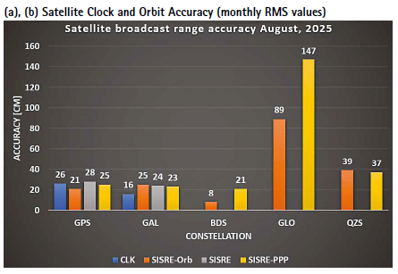
a..Satellite Broadcast Accuracy, measured in terms of Signal-In Space Range Error (SISRE) (Montenbruck et. al, 2010).
b. SISRE-Orbit (only orbit impact on the range error), SISRE (both orbit and clock impact), and SISRE-PPP (as seen by the users of carrier phase signals, where the ambiguities absorb the unmodelled biases related to satellite clock and orbit estimations. Satellite specific clock bias is removed) (Hauschlid et.al, 2020)
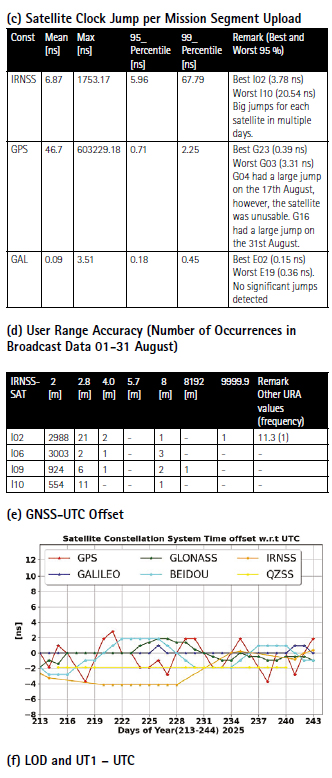
c. Clock Discontinuity: The jump in the satellite clock offset between two consecutive batches of data uploads from the ground mission segment. It is indicative of the quality of the satellite atomic clock and associated clock model.
d. URA: User Range Accuracy as an indicator of the confidence on the accuracy of satellite ephemeris. It is mostly used in the integrity computation of RAIM.
e. GNSS-UTC offset: It shows stability of the timekeeping of each constellation w.r.t the UTC.
f. LOD and UT1- UTC offset: It shows the variability in the Earth’s rotation rate and the deviation of the universal time reflected by the actual rotation of the Earth from the atomic time.
Note:- for India’s IRNSS there are no precise satellite clocks and orbits as they broadcast only 1 frequency which does not allow the dual frequency combination required in precise clock and orbit estimation; as such, only URA and Clock Discontinuity is analyzed.
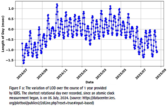
(f) LOD and UT1 – UTC
In recent months, particularly during July and August 2025, scientific community observed unusually short days, with August 5 standing out as one of the shortest ever recorded, nearly 1.25 milliseconds shorter than the standard 86,400 seconds. This sparked widespread interest and speculation online about whether the Earth is “speeding up” (Space et.al, 2025). Such variations in the Length of Day (LOD) are not uncommon and result from complex geophysical processes including atmospheric circulation, ocean tides, glacial rebound, and even interactions within the Earth’s core. LOD quantifies the daily deviation in Earth’s rotation speed from the nominal solar day and is a key component of the Earth Orientation Parameters (EOPs). The International Earth Rotation and Reference Systems Service (IERS) is the global authority responsible for monitoring and publishing data related to the Earth’s rotation, reference frames, and timekeeping standards. Using the data from IERS, the yearly variation including 2024 and 2025 looks as shown in Figure F a. There is a clear trend of a shorter length of day to longer length of day to shorter length of day. In last months of July and August, the length of day is indeed shortening. In this plot, the negative value means the shorter length of day (by the msec indicated in the y-axis) than standard SI unit of 86400 seconds.
EOPs include LOD, UT1–UTC, polar motion, and nutation/ precession, and are essential for transforming satellite orbits from the inertial reference frame (used for orbit computation) to the Earth-fixed frame (used for user positioning). A detailed discussion and analysis of such parameters were provided in earlier issue of the coordinate article (Dhital et.al, 2024). In GNSS ground segments, accurate modeling of LOD and UT1–UTC ensures that satellite ephemerides are correctly referenced to the rotating Earth, which is crucial for precise Positioning, Navigation, and Timing (PNT) services.
UT1–UTC is computed by comparing astronomical observations of Earth’s rotation (UT1), primarily via Very Long Baseline Interferometry (VLBI), with atomic time (UTC). It represents the cumulative drift w.r.t the atomic time, while the LOD is simply the derivative (change in Earth’s rotation). When UT1 UTC approaches ±0.9 seconds, a leap second is introduced to UTC to keep it aligned with Earth’s rotation. Although GNSS time scales like GPS Time and Galileo System Time do not include leap seconds, GNSS systems broadcast the GPS–UTC offset in their navigation messages. This offset is updated based on leap second decisions, which are themselves driven by UT1 UTC trends — and thus indirectly influenced by LOD. As of now, 18 leap seconds have been added to UTC, and the GPS–UTC offset remains 18 seconds, unchanged since January 1, 201.
In summary, while LOD does not directly affect GNSS timekeeping, it plays a vital role in orbit modeling and leap second planning. Accurate LOD and UT1–UTC data ensure that GNSS systems maintain synchronization with Earth rotation, enabling reliable time conversion, precise orbit prediction, and consistent positioning performance for users worldwide.
Monthly Performance Remarks:
1. Satellite Clock and Orbit Accuracy:
• The performance of all constellations remained like last months. QZSS had a degraded performance due to J04 satellite. Some of the days were removed in the statistical analysis. Further investigation is needed.
• IRNSS I09 provided higher count numbers of broadcast URA than in previous months. This indicates frequent update of the broadcast messages. Further investigation is needed. 2. The UTC Prediction (GNSS-UTC):
• All constellation provided relatively stable predictions of the GNSS-UTC.
References
Alonso M, Sanz J, Juan J, Garcia, A, Casado G (2020) Galileo Broadcast Ephemeris and Clock Errors Analysis: 1 January 2017 to 31 July 2020, MDPI
Alonso M (2022) Galileo Broadcast Ephemeris and Clock Errors, and Observed Fault Probabilities for ARAIM, Ph.D Thesis, UPC
Bento, M (2013) Development and Validation of an IMU/GPS/Galileo Integration Navigation System for UAV, PhD Thesis, UniBW.
BIMP (2024 a) https://e-learning.bipm. org/pluginfile.php/6722/mod_label/ intro/User_manual_cggtts_analyser. pdf?time=1709905608656
BIMP (2024 b) https://e-learning. bipm.org/mod/folder/view. php?id=1156&forceview=1
BIMP (2024 c) https://cggtts analyser.streamlit.app
Bruggemann, Troy & Greer, Duncan & Walker, R.. (2011). GPS fault detection with IMU and aircraft dynamics. IEEE Transactions on Aerospace and Electronic Systems – IEEE TRANS AEROSP ELECTRON SY. 47. 305-316. 10.1109/TAES.2011.5705677.
Cao X, Zhang S, Kuang K, Liu T (2018) The impact of eclipsing GNSS satellites on the precise point positioning, Remote Sensing 10(1):94
Chen, K., Chang, G. & Chen, C (2021) GINav: a MATLAB-based software for the data processing and analysis of a GNSS/IMU integrated navigation system. GPS Solut 25, 108. https:// doi.org/10.1007/s10291-021-01144-9
Curran, James T. & Broumendan, Ali. (2017). On the use of Low-Cost IMUs for GNSS Spoofing Detection in Vehicular Applications.
Dhital N (2024) GNSS constellation specific monthly analysis summary, Coordinates, Vol XX, Issue 1, 2, 3, 4
Dhital N (2025) GNSS constellation specific monthly analysis summary, Coordinates, Vol XXI, Issue 1
GINAv (2025). https://geodesy.noaa. gov/gps-toolbox/GINav.shtml
Goercke, L (2017) GNSS-denied navigation of fixed-wing aircraft using low-cost sensors and aerodynamic motion models, PhD Thesis, TUM.
GROOPS (2025) GROOPS Documentation and Cookbook. https://groops-devs. github.io/groops/html/index.html
Guo, Jing & Chen, Guo & Zhao, Qile & Liu, Jingnan & Liu, Xianglin. (2017). Comparison of solar radiation pressure models for BDS IGSO and MEO satellites with emphasis on improving orbit quality. GPS Solutions. 21. 10.1007/s10291-016-0540-2.
Guo F, Zhang X, Wang J (2015) Timing group delay and differential code bias corrections for BeiDou positioning, J Geod,
Hauschlid A, Montenbruck O (2020) Precise real-time navigation of LEO satellites using GNSS broadcast ephemerides, ION
IERS C04 (2024) https://hpiers.obspm.fr/ iers/eop/eopc04/eopc04.1962-now
IGS (2019) GNSS Attitude Quaternions Exchange using ORBEX
IGS (2021) RINEX Version 4.00 https://files.igs.org/pub/data/ format/rinex_4.00.pdf
InsideGNSS (2024) Working papers: upgrading galileohttps://insidegnss.com/ working-papers-upgrading-galileo/
Jiabo G, Xingyu Z, Yan C, Mingyuan Z (2021) Precision Analysis on Reduced-Dynamic Orbit Determination of GRACE-FO Satellite with Ambiguity Resolution, Journal of Geodesy and Geodynamics (http://www. jgg09.com/EN/Y2021/V41/I11/1127)
Kj, Nirmal & Sreejith, A. & Mathew, Joice & Sarpotdar, Mayuresh & Suresh, Ambily & Prakash, Ajin & Safonova, Margarita & Murthy, Jayant. (2016). Noise modeling and analysis of an IMU-based attitude sensor: improvement of performance by filtering and sensor fusion. 99126W. 10.1117/12.2234255.
Li M, Wang Y, Li W (2023) performance evaluation of real-time orbit determination for LUTAN-01B satellite using broadcast earth orientation parameters and multi GNSS combination, GPS Solutions, Vol 28, article number 52
Li W, Chen G (2023) Evaluation of GPS and BDS-3 broadcast earth rotation parameters: a contribution to the ephemeris rotation error Montenbruck
Liu, Yue & Liu, Fei & Gao, Yang & Zhao, Lin. (2018). Implementation and Analysis of Tightly Coupled Global Navigation Satellite System Precise Point Positioning/Inertial Navigation System (GNSS PPP/IMU) with IMUufficient Satellites for Land Vehicle Navigation. Sensors. 18. 4305. 10.3390/s18124305.
Mayer-Guerr, T., Behzadpour, S., Eicker, A., Ellmer, M., Koch, B., Krauss, S., Pock, C., Rieser, D., Strasser, S., Suesser Rechberger, B., Zehentner, N., Kvas, A. (2021). GROOPS: A software toolkit for gravity field recovery and GNSS processing. Computers & Geosciences, 104864. https:// doi.org/10.1016/j.cageo.2021.104864
Montenbruck O, Steigenberger P, Hauschlid A (2014) Broadcast versus precise ephemerides: a multi-GNSS perspective, GPS Solutions
Liu T, Chen H, Jiang Weiping (2022) Assessing the exchanging satellite attitude quaternions from CNES/CLS and their application in the deep eclipse season, GPS Solutions 26(1
Montenbruck O, Steigenberger P (2024) The 2024 GPS accuracy improvement initiatives, GPS Solutions
Montenbruck O, Steigenberger P, Hauschlid A (2014) Broadcast versus precise ephemerides: a multi-GNSS perspective, GPS Solutions
Montenbruck O, Hauschlid A (2014 a) Differential Code Bias Estimation using Multi-GNSS Observations and Global Ionosphere Maps, ION
Montenbruck, O., Schmid, R., Mercier, F., Steigenberger, P., Noll, C., Fatkulin, R., Kogure, S. & Ganeshan, A.S. (2015) GNSS satellite geometry and attitude models. Advances in Space Research 56(6), 1015 1029. DOI: 10.1016/j.asr.2015.06.019
Niu, Z.; Li, G.; Guo, F.; Shuai, Q.; Zhu, B (2022) An Algorithm to Assist the Robust Filter for Tightly Coupled RTK/IMU Navigation System. Remote Sens. 2022, 14, 2449. https://doi.org/10.3390/rs14102449
Schmidt, G, Phillips, R (2010) IMU/ GPS Integration Architecture Performance Comparisons. NATO.
Steigenberger P, Montenbruck O, Bradke M, Ramatschi M (2022) Evaluation of earth rotation parameters from modernized GNSS navigation messages, GPS Solutions 26(2)
Strasser S (2022) Reprocessing Multiple GNSS Constellations and a Global Station Network from 1994 to 2020 with the Raw Observation Approach, PhD Thesis, Graz University of Technology
Suvorkin, V., Garcia-Fernandez, M., González-Casado, G., Li, M., & Rovira-Garcia, A. (2024). Assessment of Noise of MEMS IMU Sensors of Different Grades for GNSS/IMU Navigation. Sensors, 24(6), 1953. https:// doi.org/10.3390/s24061953
Sylvain L, Banville S, Geng J, Strasser S (2021) Exchanging satellite attitude quaternions for improved GNSS data processing consistency, Vol 68, Issue 6, pages 2441-2452
Tanil, Cagatay & Khanafseh, Samer & Pervan, Boris. (2016). An IMU Monitor agaIMUt GNSS Spoofing Attacks during GBAS and SBAS-assisted Aircraft Landing Approaches. 10.33012/2016.14779.
Walter T, Blanch J, Gunning K (2019) Standards for ARAIM ISM Data Analysis, ION
Wang, C & Jan, S (2025). Performance Analysis of MADOCA-Enhanced Tightly Coupled PPP/ IMU. NAVIGATION: Journal of the IMUtitute of Navigation March 2025, 72 (1) navi.678; DOI: https://doi.org/10.33012/navi.678
Wang N, Li Z, Montenbruck O, Tang C (2019) Quality assessment of GPS, Galileo and BeiDou-2/3 satellite broadcast group delays, Advances in Space Research
Wang J, Huang S, Lia C (2014) Time and Frequency Transfer System Using GNSS Receiver, Asia Pacific Radio Science, Vol 49, Issue 12
https://cggtts-analyser.streamlit.app
Yang N, Xu A, Xu Z, Xu Y, Tang L, Li J, Zhu H (2025) Effect of WHU/GFZ/CODE satellite attitude quaternion products on the GNSS kinematic PPP during the eclipse season, Advances in Space Research, Volume 75, Issue 1,
Note: References in this list might also include references provided to previous issues.
Data sources and Tools:
https://cddis.nasa.gov (Daily BRDC); http://ftp.aiub. unibe.ch/CODE_MGEX/CODE/ (Precise Products); BKG “SSRC00BKG” stream; IERS C04 ERP files
(The monitoring is based on following signals- GPS: LNAV, GAL: FNAV, BDS: CNAV-1, QZSS:LNAV IRNSS:LNAV GLO:LNAV (FDMA))
Time Transfer Through GNSS Pseudorange Measurements: https://e-learning.bipm.org/login/index.php
Allan Tools, https://pypi.org/project/AllanTools
gLAB GNSS, https://gage.upc.edu/en/learning materials/software-tools/glab-tool-suite.


 (4 votes, average: 3.00 out of 5)


Leave your response!