| GNSS | |
Galileo Technology Centre
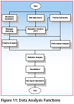
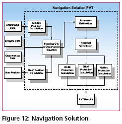
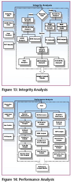
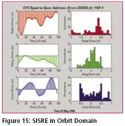
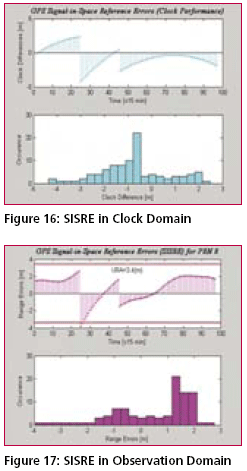
Services and AnalysisThe data analysis will be composed of various processing modules and used for performance analysis in system domain and user domain based on the raw measurements from monitoring station networks and precise ephemeris generated by GalTeC OD&TS. The main purposes of data analysis are The function and data stream are shown in the Figure 11, Figure 12, Figure 13 and Figure 14. At the beginning a twofold PVT (Position/Velocity/Time) solution is executed using in both cases the raw range measurements and then separately using broadcast ephemeris and precise orbits in the other case. This results in a nominal PVT and precise PVT solution which can be compared. The Integrity Analysis will be performed based on different integrity concepts and algorithms for Galileo, SBAS and GPS (RAIM) systems. Integrity bounds (HPL/ VPL) on navigation measurement errors are produced in the module PVT. These bounds together with the residuals generated from PVT are used to determine the confidence levels and related pass/fail criteria. The Performance Analysis will be used to process and analyse the measurements based on GNSS ephemeris for the navigation, receiver and SIS accuracy, focused on the following error analysis: satellite clock errors, satellite orbit errors, ionospheric and tropospheric errors, multipath, interference errors and measurement errors etc.. These Analysis will be complemented by some other Statistical Analysis functions and represented by appropriate Visualisation functions and then be summarised in semiautomatic Report Generation. These formalised reports are the basis for the offered regular GalTeC services. Initial Test Example With GPSBased on the description above, an initial test result using GPS measurements is presented. 24-hour measurements (May 18, 2006) from 39 worldwide deployed IGS stations are used. GalTeC OD&TS used these measurements to generate precise GPS ephemeris called reference orbits with about 18 centimetre accuracy compared with IGS precise ephemeris. The reference orbits will then be used to analyse performance of GPS broadcast ephemeris and generate related key performance parameters such as SISRE and SISRA. The maximum URA (User Range Accuracy) for one GPS satellite for one day from GPS broadcast ephemeris is used in place of SISA. The plots in Figure 15 show the SISRE in satellite orbit domain, clock domain (Figure 16) and observation domain (Figure 17). The satellite clock performance is presented for comparison purpose. Representatively, the initial results only for PRN 8 are shown here. The plots show that URA from GPS broadcast ephemeris almost over-bound the actual SISRE in the observation domain with some exception which may be caused by satellite clock jumps or jumps of the satellite clock corrections. The further analysis on the test results will be prepared in a separated paper. Conclusion and Further WorkGalTeC in its final stage will offer functions which might be expected from a Galileo Service Centre. One of the main capabilities will be the independent validation of Galileo performance and of special interest the global and regional integrity performance. However it will be a prototype to gain experience on the way towards a fully fledged and liable Galileo- or generally GNSS-Service Centre. The first prototype phase of GalTeC has been almost concluded delivering a GalTeC version 1. The GalTeC is introduced to the public already in the prototyping phase to receive first feedbacks already in the design phase as consequently services shall be developed which are considered as useful for various users. The second phase starting in January 2007 will deliver a GalTeC Version 2 in late 2008, just short before Galileo launches its 4 IOV satellites. The first version is dedicated to the development of the Reference Orbit & Clock software using GPS data for input, developing the Simulation capabilities and first Analysis and Visualisation functions. The main work will however be done with the Version 2 development where the Specifications are reviewed and adapted to the latest information available from Galileo (i.e. full Signal and Services ICDs, Mission Requirements etc.) and the (central) Galileo Service Centre. Open questions today are the availability of Galileo Signal (Giove- A and -B) within the project run time and related measurements from several sources. Also open is the availability of the Central Service Centre specification and exchange conditions for information. It is expected that the GJU and shortly the GSA willmake information available. Some limited access is given to the Thales team through participation in the Galileo development and particularly GMS verification programme, such that by end of 2008 a valuable and powerful tool will be available for experimentation. The capabilities will be demonstrated in the Galileo IOV phase. AcknowledgmentsThe authors and project members want to express their gratitude towards the DLR/Bonn for the support of the project. References1. Luis Ruiz, GJU, Galileo Overall Programme Status, Plenary Presentation ION GNSS 2005, Long Beach, Sept. 2005. |
||||||||||||||||||||||||||||||||||||
|
||||||||||||||||||||||||||||||||||||
|



 (No Ratings Yet)


