| Positioning | |
Analysıs of ınternet-based GPS processıng servıces
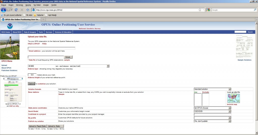
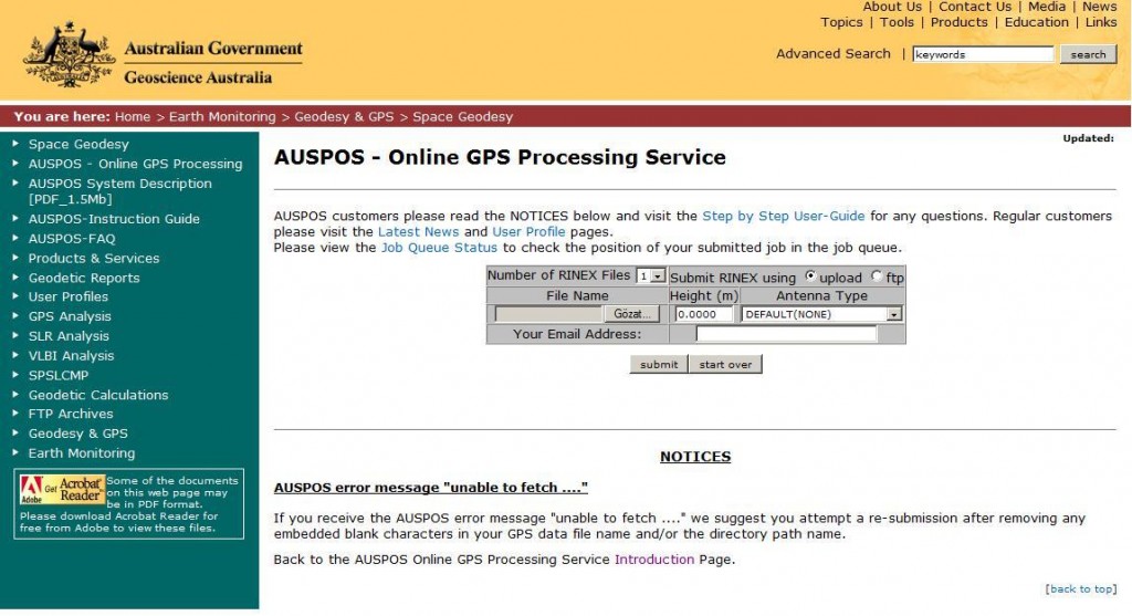
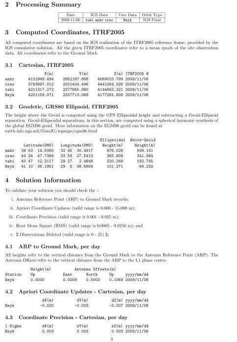
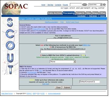
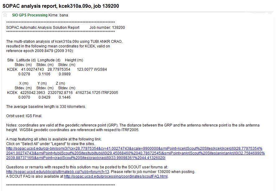
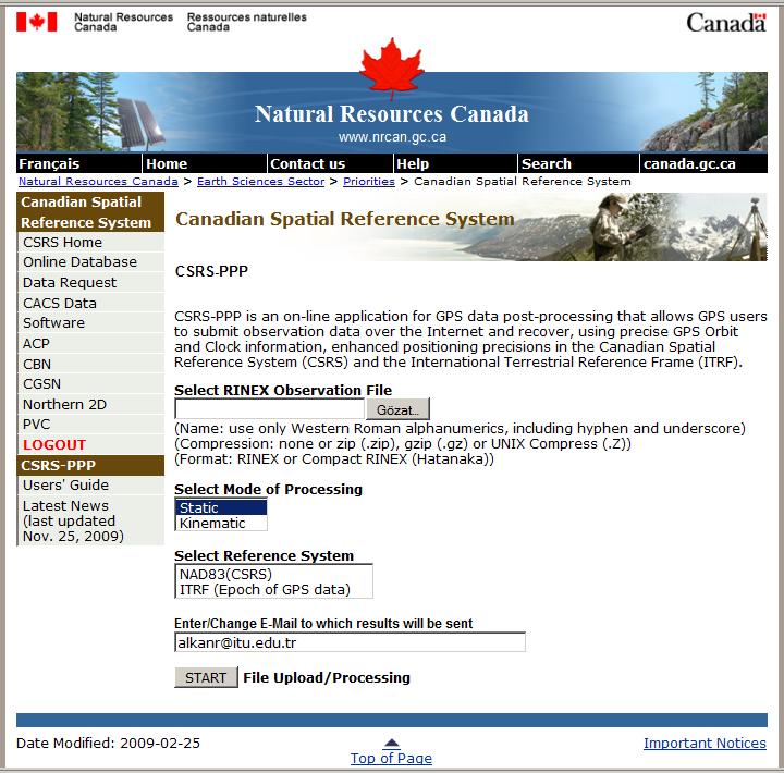
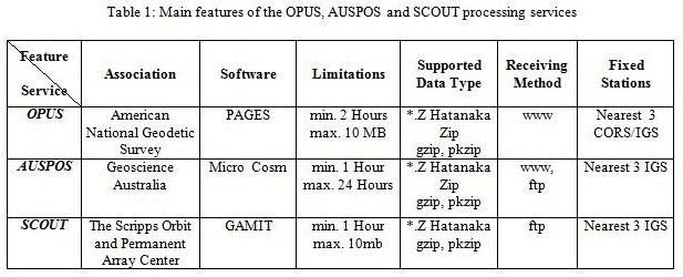
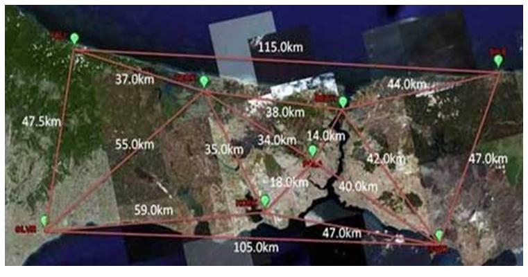
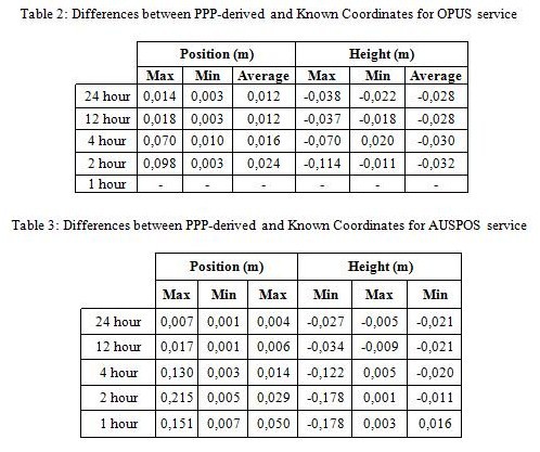
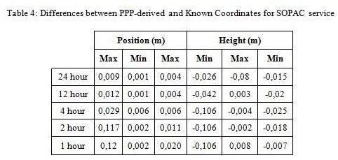
Positioning with GPS can be realized two main ways: i-Single Point Positioning (SPP), ii- relative positioning. When the high accuracy is required, the accuracy obtained from SPP is not enough and for those applications relative positioning method have to be considered. However in this method, there should be at least two receivers to collect the data and software to process these data. In order to use the GPS Processing Software, their license price must be paid and users should be take a training. For the users who do not have an experience to process GPS data with this software lasts quite long and sometimes it causes the results to be wrong. Although it removes these problems well into a certain degree with the usage of the network RTK systems named CORS- TR (TUSAGA Active), ISKI-UKBS in Turkey, it is still necessary to use traditional approaches when these systems cannot be enough or high accuracy is needed. In recent years as an alternative to the traditional processing method, internet-based on-line GPS processing services have started to widely use. With the help of these services, collected GPS data are sent to the mentioned system and then the coordinate of the stations can easily and practically be obtained. In processing, the International GNSS Services (IGS) or fixed station data of CORS networks are considered as a reference and hence the coordinates of the stations are estimated with the relative method. The most important advantage of these services is that the users can process their data just using a web browser and an e-mail without any GPS processing software knowledge. The usages of these systems are for saving both time and workforce by removing the needs of fixed station and software. In this study, the accuracy performances of the internet based GNSS processing services is analyzed. INTERNET-BASED GPS PROCESSING SERVICESTraditionally, GPS surveys are conducted at least with two receivers, i.e. reference and rover receivers and the collected data is processed with the GPS processing software in the office. In this approach, the users need to both survey with at least two GPS receivers and also use the GPS processing software. These drawbacks can be removed by using the internet-based GPS processing services (Sanlioglu and Inal, 2005). Several internet-based automatic GPS processing services are put into service in the world. Today, there are five internet based GPS processing services that can be widely used for free of charge: • Online Positioning User Service (OPUS) operated by United States National Geodetic Survey (NGS) • Scripps Coordinate Update Tool (SCOUT) operated by Scripps Orbit and Permanent Array Center (SOPAC) • Australian Online GPS Processing Service (AUSPOS) operated by National Mapping Division of GeoScience Australia • AutoGipsy operated by NASA JPL (Jet Propulsion Laboratory) • CSRS-Precise Point Positioning (CSRS-PPP) operated by Canada Geodetic Survey Division of Natural Resource Canada (NRCan). Internet-based GPS processing services use different software. For instance SCOUT uses GAMIT software; AUTO-GIPSY uses GIPSY software; OPUS uses PAGES software; CRCS-PPP uses NRCan-PPP software; and AUSPOS usesMicroCosm software. Although the mentioned software have similar mathematical principles, they can differentiate in high modeling and data quality control algorithms (Tsakiri, 2008). The necessities in order to benefit from these services are the same; internet access and an e-mail address. The widely used on-line processing services are summarized below. More detailed information is given in Subası (2011). Online Positioning User Service (OPUS)Online Positioning User Service(OPUS) is a service that was set up by American National Ocean and Atmosphere Association (NOAA). In this system, the coordinates are determined from 3 CORS stations for the USA and from 3 IGS stations for the rest of the country. The coordinates are calculated by PAGES software is used improved by NOAA (URL 1). The services web site is http://www.ngs.noaa.gov/OPUS (Figure 1). Figure 1: OPUS Web Page (http://www.ngs.noaa.gov/OPUS) After uploading the GPS data collected in the field, type and height of the antenna were also introduces to the system with the help of the easy-usable interface. In addition, the CORS stations and geoid model which will be used in process can also be selected. OPUS calculates the coordinates by taking the results from three independent base vectors. After entering all the necessary information, process starts and results are sent to the e-mail address. For a single station, the process lasts approximately 15-20 minutes. The result message sent via mail includes user name, the studied file’s name, used software’s version, type and height of the used antenna, calculated survey epoch coordinates, used reference stations’ names and coordinates. The OPUS system can process the survey files at most 10 Megabyte size and produced by at least 2 hours with dual frequency receivers. The result files sent to the user after the processing consist of survey epoch coordinates, UTM coordinates, type and height of the antenna, starting and ending times of the survey, ambiguity solution rate and so on (Figure 2). Figure 2: OPUS Service Result File Australian Online GPS Processing Service (AUSPOS)It is an online GPS data processing service prepared by Geoscience Australia Association. In this system, the coordinates are determined with the help of the 3 nearest IGS station. In the processing stage, IGS precise orbit information, earth rotation parameters and speed vectors of IGS stations are taken into count. For these evaluation, a GPS survey software is used named MicroCosm. Users can be reached to the AUSPOS processing service via http://www.ga.gov.au/bin/gps.pl web address (Figure 3). Figure 3: AUSPOS Web Page (http://www.ga.gov.au/bin/gps.pl) Through the service’s interface screen, users start the survey process by entering their e-mail addresses, type and height of antenna. Users can install the data both via interface and a ftp server. RINEX files can be installed in the zipped Hatanaka, *.zip or *.gzip format. In AUSPOS system 7 survey file can be processed at the same time. A survey file of a single day can be processed in approximately 15 minutes and the results are sent via e-mail (Subasi, 2011; URL 2). In addition to the lots of standard information in the result files, there are also a map shows the location of the stations on the world map, mean-square error values and used troposphere model (Figure 4). Figure 4: AUSPOS Service Result File Scripps Coordinate Update Tool (SCOUT)Scripps Coordinate Update Tool (SCOUT) is a data processing service set up by California University. It broadcasts under the SOPAC (Scripps Orbit and Permanent Array Center) Association. The service page can be accessed from http://sopac.ucsd.edu/cgi-bin/SCOUT.cgi address (Figure 5). The GPS data files are uploaded in two stages. In the first stage, e-mail and survey files’ ftp address to which the results are sent, are entered by using the interface screen (in SCOUT service data can only be sent via ftp). In this stage, it is possible to choose IGS stations that will be use as a reference station. The processing of the data is started after entering antenna type and height. The baselines is calculated from nearest 3 IGS stations and the coordinates are calculated by making a network adjustment. The data entered to the system should be at least 1 hour with a 30 seconds interval. The survey files can be in Hatanaka format or any other zipped formats. However, data in *.zip format is not supported. The SCOUT service uses GAMIT software (URL 3). Figure 5: SCOUT Web Page (http://sopac.ucsd.edu/cgi-bin/SCOUT.cgi) In the result file sent after the processing, coordinate information (survey epoch and ITRF 2005) andnames of the used reference stations are sent in text file to the users (Figure 6). Figure 6: SCOUT Service Result File Canadian Spatial Reference System-Precise Point Positioning (CSRS-PPP)Canadian Spatial Reference System-Precise Point Positioning (CSRS-PPP) is an internet based GPS survey service supplied by NRCAN (Natural Resources Canada). A single point positioning is determined by using Precise Point Positioning technique with precise orbit and clock information (Sanlioglu and Inal, 2005). The single or dual frequency GPS data can be processed in static or kinematic mode with this service. CSRS-PPP services internet page can be accessed by http://webapp.csrs.nrcan.gc.ca/field/Scripts/CSRS_PPP_main_e.pl address (Figure 7). Figure 7: CSRS-PPP Web Page (http://webapp.csrs.nrcan.gc.ca/field/Scripts/CSRS_PPP_main_e.pl) The main features of the OPUS, AUSPOS and SCOUT services are given in Table 1. CASE STUDYIn this study, six continuously operating GPS stations, operated by ISKI-UKBS, are selected in order to analyse the performance of the on-line processing service (Figure 8). Figure 8: ISKI-UKBS Network A GPS surveying campaign was conducted in 2008 and the coordinates were calculated by using BERNESE software very precisely. The details of the study are given in Kahveci et al. (2009). The 6 points have 24 hours GPS sessions on May 16th 2009 and November 6th 2009 are chosen. 24 hour data files were divided into 1 hour, 2 hour, 4 hour, 12 hour sub-sessions. All these data sets were processed with OPUS, AUSPOS and SCOUT services. Delivered coordinates from these services are compared with known coordinates. Differences in position and ellipsoidal height components are shown in Table 2, 3 and 4 for the OPUS, AUSPOS and SOPAC, respectively.
When analyzing the results in Table 2, 3 and 4, it can be seen that results are obtained between 1 cm and 22 cm accuracy level in position from all services. In height as expected, results are obtained with the less accuracy. To get sub-decimeter accuracy at least 2 hour data acquisition time needed. The results show that, the SCOUT service among the others provides the best accuracy. RESULTSIn this study, the accuracy performance of internet-based online GPS processing service is analyzed. The results show that, coordinates are estimated between 1 cm and 22 cm accuracy level in position from all services. To get sub-decimeter accuracy at least 2 hor data span is required. The results show that these services can be used lots of surveying applications with a cost-effective manner and very easily without knowledge of any GPS processing software. ReferencesGhoddousi-Fard, R. and Dare, P., 2006. Online GPS Processing Services: An Initial Study, GPS Solutions, 10(1), pp. 12-20. Liu, J. H., and Shih, T. Y., 2007. A Performance Evaluation of The Internet Based Static GPS Computation Services, Survey Review, 39(302), pp. 304-308. Kahveci, M., Karagoz, H., Gulal, E., Kartal, U,Eroglu, S. and Tokmak, B., 2009. ISKI Real Time Permanent GNSS Network (ISKI-UKBS): Its Establishment and Practical Applications, 4. National Engineering Surveying Symposium, 14-16 October, pp.365-384, Trabzon, Turkey. Macdonald, D., 2002. Auto-GIPSY, Grafnet, OPUS and SCOUT; A comparison, Waypoint Constulting Inc., Canada. Subasi, H.K., 2011. The Accuracy Analysis of Web Based GPS Processing Services: The Case of Istanbul, MSc Thesis, İTÜ, Istanbul (in Turkish). Şanlıoğlu,I., Inal.C., 2005. Web Tabanlı Otomatik Veri Işleme Sistemi Tasarımı, 10. TMMOB Harita ve Kadastro Mühendisleri Odası, 10.Türkiye Harita Bilimsel ve Teknik Kurultayı, 28 Mart – 1 Nisan, Ankara. Tsakiri, M., 2008. GPS Processing Using Online Services, Journal of Surveying Engineering, 134(4), pp. 115-125. URL 1, OPUS website, http://www.ngs.noaa.gov/OPUS, 01 March 2011. URL 2, AUSPOS website, http://www.ga.gov.au/bin/gps.pl, 01 March 2011. URL 3, SCOUT website, http://sopac.ucsd.edu/cgi-bin/SCOUT.cgi, 01 March 2011.
|






 (3 votes, average: 1.33 out of 5)


Leave your response!