| Mapping | |
eHarta tryst with Romania
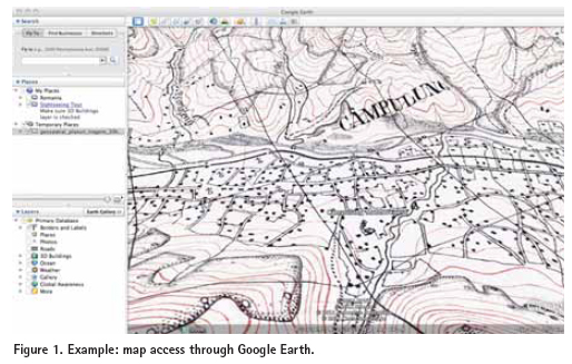
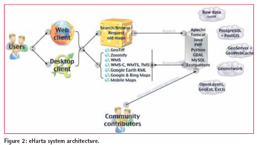
Historical maps represent a valuable cultural and scientifi c heritage. Maps are much more than just physical representations of a territory at a certain time. Personal beliefs, political interests and cultural views are also a part of the message sent by maps through time. eHarta is a collection of thousands of georeferenced historical maps, published and documented with the help of the community. It is a collaborative initiative to digitally preserve and freely share old cartographic documents. The datasets are published by geo-spatial.org – a collaborative online platform aiming to facilitate the sharing of geospatial knowledge and the discovery and publishing of free geographic datasets and maps for the Romanian community. The project has many similarities with this kind of projects, such as the project initiated by the National Library of Scotland in collaboration with Klokan Technologies GmbH, but some remarkable differences as well. The most important features of the project are described below: • eHarta aims to offer free online access to thousands of old map sheets and atlases. All the maps are made available for download as georeferenced independent fi les and accessible through a number of web services that fi t a broad range of users (e.g. Zoomify tiles or KML fi les for ordinary users; standard geospatial services like WMS/WMTS for users with advanced GIS skills). • eHarta has no fi nancial resources available. It completely depends on community contributions (e.g. metadata creation, data processing, etc.), institutional donations (e.g. Internet bandwidth, free access to map archives, access to high performance scanners and other digital preservation instruments) and free and open source software usage. Community involvementCommunity powered projects are no longer a novelty. Online initiatives like Wikipedia or OpenStreetMap proved that it is possible to achieve incredible results, both in quality and quantity, only with volunteers, open data/knowledge model and an adequate set of web tools. eHarta employs the same principles and methods like other online collaborative projects: • Friendly web interfaces for old map related operations (e.g. metadata creation, add control points for georeference, image enhancements, etc.); • Feedback channels • Open data license for the fi nal products • Public recognition of each member contribution • User content control mechanisms For the eHarta project the geo-spatial.org members were invited to contribute with their time, knowledge, and experience. In just two months after the project’s launch more than 200 accounts were registered. We consider the number to be quite signifi cant when talking about a niche community like the Romanian historical cartography passionate individuals. More importantly, thousands of map sheets were processed in just two to three days after digital scans were made available. eHarta project started with the publication of the 1:20.000 Romanian map series under the ‘Lambert-Cholesky’ projection system. The maps were created after World War I, for military purposes (especially artillery). More than 1,800 map sheets from this collection were identifi ed in archives belonging to the Faculty of Geography – University of Bucharest, Faculty of Geography – University Babes Bolyai, Institute for Cultural Memory and the National Museum of Romanian History. The maps were scanned at 300 dpi and saved as uncompressed TIFF fi les. Zoomify versions were later derived for metadata creation and identifi cation of control points for georeferencing. Several web user interfaces were created to facilitate the community’s involvement. The fi nal step of this fi rst eHarta project was to publish the maps as raw fi les and standard web service (Figure 1). ArchitectureeHarta online system was designed following a distributed architecture, entirely based on free and open source software. The content is managed by Textpattern, a powerful and fl exible open source content management (CMS) application. For supplementary, specifi c functionality, custom modules were built. Other free applications are providing server-side functionality: MySQL (relational database management system), PHP, Python, Java (serverside scripting languages), Apache (webserver), Tomcat (servlet container), phpMyAdmin, phpPgAdmin (web clients for database management). For geospatial data management, top open source applications were also integrated in the website: PostGIS (vector geospatial data storage), GeoNetwork (geospatial data catalog and metadata editor), GeoServer (standard geospatial server for serving data via WMS), GeoWebCache (Java based WMTS/TMS server, with pluggable caching mechanisms and rendering backends), OpenLayers and GeoExt (client webmapping application), GDAL (data processing). The information fl ow between the various server side applications and the front-end graphical interface is determined by the interaction with the portal users and their requests (Figure 2). Public recognitioneHarta collaborative project won the ‘Better Data Award’ at ‘Open Data Challenge’. The prize was awarded at the Digital Agenda Assembly, being held in Brussels on 16th and 17th June 2011, by the European Commission Vice-President Neelie Kroes. Organized by the Open Knowledge Foundation and the Open Forum Academy under the auspices of the Share-PSI initiative, the Open Data Challenge invited designers, developers, journalists, researchers and the general public to come up with useful, valuable or interesting uses for open public data. It attracted 430 entries from across the EU. Entries were invited in four categories for prize money totaling €20,000. The categories were fully blown apps, ideas, visualisations and liberated public sector datasets. The winners were selected by open data experts, including the inventor of the World Wide Web Sir Tim Berners-Lee. Future opportunities of developmentThe success of the eHarta project was beyond expectations, if we are to The success of the eHarta project was beyond expectations, if we are to consider the number of contributors and the appreciation received from third parties, beyond Romanian borders. The attention led to more than one perspective in the future development of the project. We were offered the umbrella of an international renown, openhistoricalmap.org, or the possibility of integrating our map collections in the oldmapsonline.org project. Another interesting possibility is the extension at a regional dimension of the eHarta project itself. There have been concrete offers of datasets from Hungary, Poland, Czech Republic, Ukraine and France to integrate within our project. (http://earth.unibuc.ro/articole/eHarta?lang=en)
|


 (3 votes, average: 2.67 out of 5)


Leave your response!