| Surveying | |
Pushing the planning boundaries: A case of forensic surveying
This paper outlines the case of a Canberra homeowner and their architect stretching the planning rules beyond the limits and a surveyor’s critical role in a court case relating to the rules for home construction. |
 |
|
Abstract
Legislation plays a vital role in cadastral surveying and town planning, and on occasion surveyors are asked to give evidence at court. This paper outlines the case of a Canberra homeowner and their architect stretching the planning rules beyond the limits and a surveyor’s critical role in a court case relating to the rules for home construction. In Deakin, an old and prestigious suburb of Canberra, 2-storey dwellings are the maximum size permitted. However, what constitutes a ‘storey’ and ‘basement’ are critical to the extent one can build. In this case, a dwelling was erected. The owner, their architect, a certifier and the Government Planning Authority believed that the dwelling satisfied the planning rules. A neighbour disagreed and took the matter to the ACT Civil & Administrative Tribunal. Critical to the case was the determination of the ‘datum ground level’ and the position of the contour a metre below the floor level above the lowest level. This paper describes the investigation to determine the datum ground level, involving research of contour plans dating back as far as 1910 and aerial imagery dating back to 1951. The datum ground level determination required ascertaining the levels at the time of operational acceptance for subdivision, which in this case was 1951. The methodology used to determine the datum ground level and its location involved the following 9-step process: (1) Analyse the definition, (2) determine the time stamp required for datum ground level, (3) plan the research, (4) locate the site on the contour plan, (5) determine a consistent datum, (6) search and analyse aerial imagery, (7) trace locations into a Computer-Aided Design (CAD) file, (8) interpolate the data, and (9) decide on the best solution for the datum ground level and its location. It was concluded that the critical datum ground level contour passed through the bedroom on the upper level, meaning that the dwelling should be deemed to be a 3-storey building and not permitted on the site.
1. Introduction
Legislation plays a vital role in cadastral surveying and town planning, and on occasion surveyors are asked to give evidence at court. This paper provides an example by outlining the case of a Canberra homeowner and their architect stretching the planning rules beyond the limits and the surveyor’s critical role in a court case relating to the rules for home construction.
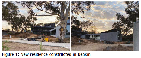
A new residence has been constructed on Block 5 Section 9 at 8 Gawler Crescent in Deakin, Australian Capital Territory (ACT) (Figure 1). A dispute has arisen as to whether the building is a 2-storey or 3-storey building. On visual inspection, the building clearly has three levels. However, the owner and the architects who designed the building contend that part of the lower level is a basement and that the third level is constructed over the basement. If the third level is constructed over a basement, the building can be considered as a 2-storey building.
Basement means a space within a building where the floor level of the space is predominantly below datum ground level and where the finished floor level of the level immediately above the space is less than 1.0 m above datum ground level. Whether part of the lower level is a basement and, if it is, where that part of the basement is located with respect to the upper level is dependent on the position of datum ground level. This paper examines the issue of datum ground level and makes a determination as to its location.
2 Definition of datum ground level
The Territory Plan defines datum ground level as the surface ground level as determined in a field survey authorised by a registered surveyor (ACT Government, 2024a):
a. at the time of operational acceptance for subdivision, or
b. if a) is not available, provided no new earthworks have occurred, or
c. at the date of grant of the lease of the block, whichever is the earliest.
Where a), b) or c) is not available, datum ground level is the best estimate of the surface ground level determined in a field survey, considering the levels of the immediate surrounding area and authorised by a registered surveyor.
The author believes that a) and c) in this instance will be the same. Option b) does not apply as earthworks have occurred. The options a) or c) can be deduced from old plans or databases before or after the date and confirmed by comparing recent surveys of undisturbed areas in proximity of the site
The following assumptions are made:
• Datum ground level means the existing level of a site at any point. It is not a single level.
• A registered surveyor includes the equivalent status utilised at the time of the survey. (Charles Scrivener was a licensed surveyor.) Government departments with registered/licensed surveyors are included in the definition.
• A field survey includes photogrammetric or Light Detection and Ranging (LiDAR) surveys conducted by aircraft or drones.
It should be noted that the SurveyorGeneral of the ACT has issued a guideline in 2013 relating to the determination of datum ground level. As it is inconsistent with the Territory Plan (ACT Government, 2024a) and National Capital Plan (Australian Government, 2020), the Territory Plan definition is considered to be that which should be used in the determination. Unfortunately, due to its existence, confusion exists as to the definition to be adopted and thus the value of datum ground level.
The definition in the guideline states (ACT Government, 2013): “Datum ground level means the level of the surface of the ground as defined in a field survey and authorised by a qualified surveyor at the time of operational acceptance for greenfield development or prior to any new earthworks having occurred after that time.”
The key difference between the definitions is that the Territory Plan provides three options and specifically states that if available the earliest should be adopted. The guideline definition requires that for non-Greenfields developments the level is that level prior to any new earthworks having occurred after that time. Thus under the Territory Plan definition, the datum ground level is the level before construction in 1955, while under the guideline the level is that level of the ground before construction commenced for the new dwelling, which is the level defined in the plan produced by Capital Surveys in 2020 (see section 4.7).
A second difference is that the Territory Plan requires the authorisation of a registered surveyor, whilst the guideline requires the authorisation of a ‘qualified surveyor’, whose definition includes surveyors other than registered surveyors.
3 History of the site
Deposited Plan (DP) 316 was signed by the licensed surveyor on 14/05/1951 and certified by the Acting Surveyor-General on 01/08/1951 (Figure 2). It is likely that ‘operational acceptance’ occurred earlier in 1951 or late 1950. The date of survey was 10/10/1950. The lease of Block 5 Section 9 was granted on 14/07/1951.
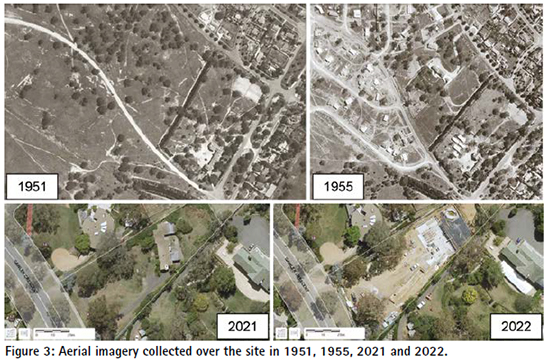
Over the years, several aerial images were collected over the site (Figure 3). Older aerial imagery revealed the following:
• 1951: Only scattered tracks crossed the site. No significant earthworks had occurred.
• 1952: Works appeared to have commenced with the construction of Westminster House on the adjacent Block 4 south-east of the site.
• 1955: Dwellings had been constructed on adjacent Blocks 4 and 18, while earthworks had commenced on the subject site.
• 1958: The dwellings on Blocks 5 and 6 appeared to have been constructed.
• 1962: Extensions were added to 8 Gawler Crescent (at the rear of the existing building).
Recent history included:
• May 2021: Environment, Planning and Sustainable Development (EPSD) consideration. • September 2021: Certifier approval for the proposed dwelling.
• May 2023: Certifier approval of amendments.
Recent aerial imagery indicated:
• 2004 & 2015: Original home with access driveway. Apparent undisturbed areas around a regulated tree south of the dwelling on Block 6 and in the rear of Block 18. Figure 1: New residence constructed in Deakin
• 2022: Original home demolished, construction of new dwelling underway with extensive earthworks, but undisturbed areas remain under the tree on Block 6 and in the rear of Block 18.
4 Contour plans
The following contour plans indicating levels have been found relating to the site:
• 1910 contour map of Canberra – Charles Scrivener (1910).
• Site plan 10 Gawler Crescent – Unknown (1955-1958).
• Site plan 8 Gawler Crescent – Unknown (1955).
• ACT Contour Series (7C) – Department of the Interior (1960).
• ACT Contour Series (8A2) – Department of the Interior (1960).
• Canberra-by-Suburbs – ACT Survey Office (pre-2000).
• ACTmapi 2015 contours – ACT Survey Office (2015).
• 2015 LiDAR data – ACT Survey Office / Geoscience Australia (2015).
• Contour and detail surveys – Capital Surveys (2020).
The following sections describe these contour plans in more detail.
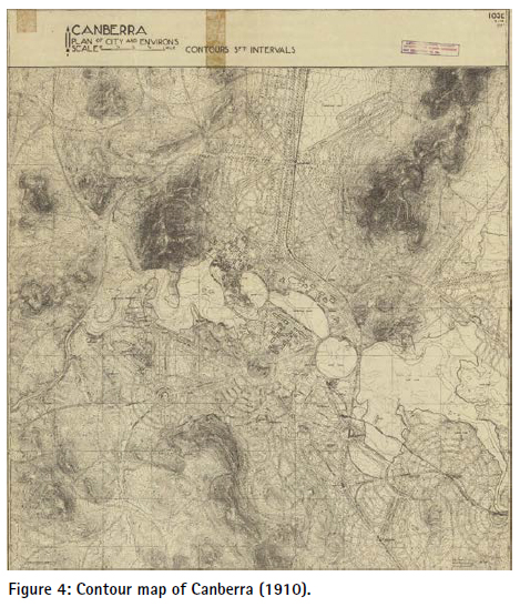
4.1 Contour Map of Canberra (1910)
The only comprehensive source of heights (levels) found prior to 1951 was the 1910 contour map of Canberra prepared under the supervision of Charles Scrivener (Scrivener, 1912) (Figure 4). As existing trigonometrical (trig) stations were shown on the plan, it is possible to ‘locate’ the subject site on the plan and hence use the contours from the plan. These contours would be indicative of the levels at the time of issue of the lease and commencement of the subdivision in 1951. The contour intervals are 5 ft, indicating a reasonably high level of accuracy.
The levels are given in feet and thus can be converted to metres. However, the height datum for levels has changed over the years with the ACT adopting the Australian Height Datum (AHD) in 1971 (Daly, 1972; Evans, 2022). To relate the Scrivener and 1964 levels to the current levels would thus require adaptation. On the other hand, the Canberra-by-Suburbs levels and current surveys relate to the AHD. The adaption may normally involve comparing level values of bench marks from early surveys to what they are and adjusting contours accordingly. For example ‘West of School’ trig is shown on the Scrivener plan as having a level of 1,978 ft, which converts to 602.894 m, whilst its level now provided in the ACTmapi database (ACT Government, 2024b) is 602.265 m.
A more realistic approach was to adopt areas close by, which do not appear to have been affected by earthworks and compare levels shown on the various level sources to determine an appropriate datum. The ACTmapi contours appear to have been based on the 2015 LiDAR data, so could be used as a source for comparison with the 1910 survey.
In summary, this 1910 plan provides an early indication of the levels of the site. However, the accuracy is questionable due to:
• The distortion in creating the image.
• The scale of the plan relative to the site.
• The methodology for determining heights was less accurate than the methods used today.
• The levels of bench marks have changed over time, and the height datum has been changed to AHD.
Nevertheless, the 1910 contours do give an indication of the even slope over the site.
4.2 Site Plan 10 Gawler Crescent (1955-1958)
This site plan was obtained from an image of the house design provided by Berkely Real Estate on the allhomes website. Unfortunately, the image is not clear and as a result neither the contour values nor the responsible surveyor’s name can be read. Values for the contour intervals can be gauged by comparing the contours on recent plans (either Capital Surveys or ACTmapi contours), thus providing an indication of the levels along the boundary between Blocks 5 and 6.
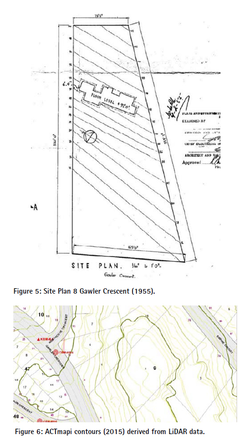
4.3 Site Plan 8 Gawler Crescent (1955)
This site plan forms part of building plans submitted by Ancher, Mortlock and Murray, Architects. The plan is rough, with boundaries not scaling to match the dimensions of the block (Figure 5). No indication is provided as to the derivation of the contours, or whether the survey was authorised by a registered surveyor. Contours are provided at 2 ft intervals based on a local datum. However, the floor level of the dwelling is provided as 92 ft.
As the later survey by Capital Surveys determined a height of the floor level, it was possible to derive contour values based on the Capital Surveys floor level (average of 618.8 m). Thus, whilst the plan appears to be rough and the accuracy may be queried, the plan does provide the most direct indication of datum floor level.
4.4 ACT Contour Series (7C and 8A2) (1960)
Plan 7C indicates contours and also that a dwelling had been constructed on the site before that time. Hence earthworks would have occurred around the site of the dwelling, which is also the approximate location of the existing dwelling. Plan 7C has 5 ft contour intervals, while Plan 8A2 (which extends into Block 4 south-east of the site) has 1 ft contour intervals. Plan 7C indicates fencing on or close to the boundaries, so a good indication of the relative position of the boundaries and contours can be plotted. Plan 8A2 shows the boundaries as opposed to boundary fences, thus providing greater accuracy. Plan 8A2 also again illustrates the even gradient of the land near the subject site. As these plans were prepared after the construction of the dwellings and as the conversion to AHD occurred after 1960, these plans have not been used.
4.5 Canberra-by-Suburbs Contour Set (Pre-2000)
A Computer-Aided Design (CAD) file dataset of boundaries, contours, building outlines and other features was provided by the ACT government before the commencement of ACTmapi. The origin of the contours is unknown, but it is known to have been provided before 2000. The contours were not used as they were determined after construction work was undertaken and have been superseded by the LiDAR survey of 2015.
4.6 ACTmapi Contours and LiDAR Levels (2015)
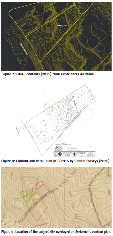
The ACTmapi contour database is based on 2015 LiDAR survey data and provides a good indication of the levels on the site and surrounding areas before construction began on the newly constructed dwelling (Figures 6 & 7). It also enables the determination of level values of apparently undisturbed land close to the site of the residence (at the rear of Blocks 5 and 14, and around the regulated tree near the boundary adjacent to the residence at 10 Gawler Crescent). The ACTmapi contours are a smoothed version of the contours from the Geoscience Australia point cloud.
4.7 Contour and Detail Plan of Block 5 by Capital Surveys (2020)
This survey covers the area on which the new dwelling has been built (Figure 8). It is referred to AHD and largely consistent with the ACTmapi 2015 contours. The survey was undertaken before the old dwelling was demolished and one can determine contours through apparently undisturbed areas. The plan was certified by a registered surveyor.
Thus it was possible to suggest that the contours at the rear (north-east) of Block 5 (621 m) and the contour running close to the regulated trees (615 m) are largely undisturbed. Assuming the even slope shown in the Scrivener and other plans, a justifiable datum ground level for the site could be interpolated between the 615 m and 621 m contours.
5 Methodology
Following the decision to use the Territory Plan definition, the methodology used to determine the datum ground level and its location involved the following process: (1) Determine the time stamp required for datum ground level, (2) plan the research, (3) locate the site on the contour plan, (4) determine a consistent datum, (5) search and analyse the aerial imagery, (6) trace locations into a CAD file, (7) interpolate the data, and (8) decide on the best solution for the datum ground level and its location.
5.1 Determine the time stamp required for Datum Ground Level
The Crown Lease and Deposited Plan (DP316) were examined to determine the date of operational acceptance for subdivision and the date of grant of the lease of the block. This was determined to be between October 1950 and August 1951.
5.2 Plan the research
A thorough investigation was made of sources of levels, encompassing 90 years between Scrivener’s original contour survey in 1910 and the survey of the subject site by Capital Surveys in 2020. The acquired contour plans have already been discussed in section 4.
5.3 Locate the site on the contour plan
The locations of the Scrivener contours could be approximately determined using trig stations and survey marks shown on the plan that either still exist today or for which coordinates are still available (Figure 9). Some versions of the Scrivener maps also included grids and street overlays. The ACTmapi historical plans website provides an overlay of the cadastral boundaries over old maps.
5.4 Determine a Consistent Datum
The acquired plans had varying coordinate and level datums. These datums needed to be correlated to ensure consistent comparisons could be made and the site analysed.
5.5 Search and Analyse the Aerial Imagery
It was necessary to determine when construction began and the extend of excavations on the site and neighbouring properties. ACTmapi provides historical aerial imagery dating back to the early 1950s (see Figure 3). From these images, it was possible to determine the extent and year of excavation, along with identifying unexcavated areas. Based on this information, contours shown within the excavated areas on plans prepared after the date of excavation were discounted. Modern imagery is available via ACTmapi as well as other sources such as Nearmap. By comparing the recent imagery with the imagery from the 1950s one could determine areas on or close to the site where little or no excavation had taken place. Levels in those areas could thus be used as an indication of the datum ground level.
5.6 Trace Locations into a CAD File
Based on the information provided on the site plan of the architects, Collins Pennington, and the survey report plan of Kleven Spain, it was not possible to accurately plot the position of the new dwelling. Unfortunately, CAD data was not provided. However, modern CAD packages such as AutoCAD allow the user to import other files (including images) into the CAD file.
The site and floor plans of the dwelling were thus scanned as jpg files and imported into the CAD file. As these drawings showed the location of the dwelling as well as the boundaries, it was possible to scale and rotate the images to reflect the scale and orientation of the CAD file. The ACTmapi database includes accurate cadastral information, allowing the site coordinates to be determined on the required grid. The now scaled and rotated images were then overlaid with the boundaries obtained from the ACTmapi database, and the positions of the dwelling and associated floors were traced into the CAD file.
In a similar way, contours shown on acquired plans could be traced into the CAD file and used to determine the datum ground level. Thus, datum ground levels for strategic points of the new dwelling could be interpolated from this data.
5.7 Interpolate the Data
Contours are not a precise determination of heights surveyed. The denser the survey of heighted points, the more accurate is the resulting contour. Contours are determined by interpolating on a straight line between points for which a height has been surveyed. This process is repeated multiple times between the points surveyed to obtain the contour on which datum ground level can be based. Modern software does this process very quickly using a triangular mesh over the points surveyed.
Similarly to determining the contour by interpolation, heights associated with various parts of a building can be determined by interpolating either between surveyed points (if available) or by interpolating between the contours.
In order to determine the datum ground level, the following two interpolation processes were applied:
• Interpolation between adopted contour lines (in unexcavated areas) to approximate the contours over areas which had been excavated.
• Interpolation of datum ground levels from the contours adopted or interpolated for positions of the dwelling.
5.8 Decide on the Best Solution for Datum Ground Level
Based on this interpolation, the following two result options were determined:
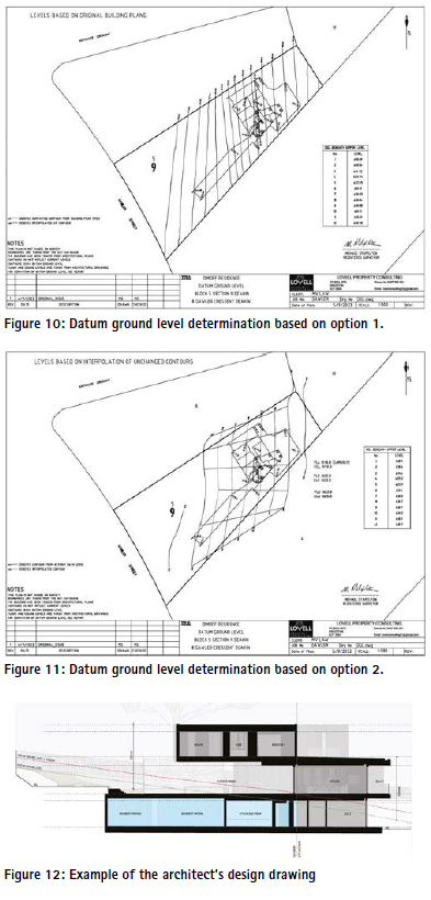
4. The contours obtained from the recent surveys (Capital Surveys confirmed by ACTmapi contours), being the 615 m and 621 m contours, were interpolated evenly to obtain the contours between these values. This approach is justified due to the even distribution of contours shown on earlier plans, and it can be shown that the plans used were produced under the authorisation of a registered surveyor. The results are shown in Figure 10.
5. The contours were determined using the site plan in the building plans of the dwelling constructed in the 1950s and shown relative to the floor level. Capital Surveys surveyed three floor levels in the old dwelling with very consistent results. A rounded average of 618.8 m was adopted, and the contour values of the building plans were then converted to this datum. It is likely that the Capital Surveys plan was the contour survey used by the architects for the design of the new dwelling. Thus using the building site plan to reflect datum ground level before excavation began, the datum ground levels for positions of the new dwelling were determined. This method is more direct and positively reflects levels at the time relative to the building floor level. However, option 1 was also provided as the origin of the levels used in option 2 is uncertain, and it is further unknown if the survey was conducted under the authority of a registered or licensed surveyor. The results are shown in Figure 11.
In the author’s opinion, option 2 should be adopted. The two options produced reasonably consistent results for the datum ground level. Importantly, both options determined the critical 619 m contour further to the east from that adopted in the design of the new dwelling. The location of the 619 m contour (from both options) passes through the bedroom located on the upper level of the new dwelling. Consequently, the dwelling should be considered to have three storeys and is therefore in contravention of the building code for the area.
On the provision of the author’s report as evidence for the case, the ‘other side’ produced reports from surveyors expressing their views and rebutting the evidence provided. As a consequence of these reports, further investigation was required into the views expressed therein and the author was asked to address queries raised and provide his own rebuttals. One of the issues which arose was the creation of contours from a triangular mesh and how different critical contours could be portrayed if alternative contours were adopted.
6 The design and the contention enabling the upper floor
The architect made a determination that the lowest contour relevant to enabling part of the lowest floor to be considered as basement was the 619 m contour. The floor level of the middle level was thus designed as 620 m, and all of the lower level built on land with a datum ground level above 619 m should be considered as basement. This would enable an additional storey to be constructed above that part of the lowest level considered a basement. In the design, the 619 m contour passed through a balcony on the upper level. The architect did not consider the balcony to be part of the building for the determination of the number of storeys. The building certifier and the ACT government authorities agreed with the architect’s view. The design is illustrated in Figure 12. The determination of the location of the 619 m contour in the datum ground level investigation could thus be critical to whether the dwelling has two or three storeys.
7 Concluding remarks
The dispute went to court, the ACT Administrative Appeals Tribunal. Most of the initial evidence was provided by surveyors: the author for the neighbour, another surveyor for the ACT government and a third for the homeowner.
The evidence presented by the author was largely as described in this paper. Questions were raised regarding:
• The use of LiDAR and photogrammetry intended for macro use in a micro use individual block scenario.
• The accuracy of old data.
• The use of plans not signed by a registered surveyor.
• The interpolation of contours where levels had clearly been disturbed.
• The identification of which areas were disturbed and which areas were not.
• The definitions of datum ground level.
From the start, the Senior Member presiding over the case made it clear that in his mind, based on a site inspection, the building consisted of three stories and was hence illegal. He suggested that if others thought otherwise, they would need to change his mind, and suggested further that the parties may wish to liaise and seek a compromise. Before the end of presenting the evidence, a compromise was reached, where the dwelling would be allowed to stand, regardless of whether legal or not, but all windows facing the neighbour were to be bricked in and a covenant inserted in the lease to the effect that no windows were to be permitted to be inserted in the wall facing the neighbour.
Unfortunately, as a consequence of the compromise, it is possible that no judgement will be made regarding the survey issues raised in the case. It seems that in the Senior Member’s view, the planning boundaries were pushed a little too far. In this case, it was shown that a Canberra homeowner and their architect were possibly stretching the planning rules beyond their legal limits and the surveyor was critical in providing an expert opinion in this regard.
References
ACT Government (2013) SurveyorGeneral of the Australian Capital Territory Guideline 12 – Datum Ground Level, https://www. planning.act.gov.au/professionals/ resources (accessed Mar 2024).
ACT Government (2024a) Territory Plan, https://www.planning. act.gov.au/professionals/ourplanning-system/the-territoryplan (accessed Mar 2024). ACT Government (2024b) ACTmapi, https://www.actmapi.act.gov. au/ (accessed Mar 2024).
Australian Government (2020) National Capital Plan 1990 (December 1990), https://www.legislation. gov.au/Details/F2020C01103 (accessed Mar 2024).
Daly P.B. (1972) Conversion of ACT level datums to Australian Height Datum, Survey Branch, Department of the Interior, Canberra.
Evans G. (2022) A short history of heights in the ACT, Office of the Surveyor-General and Land Information, Environment Planning and Sustainable Development Directorate, Canberra, https:// www.planning.act.gov.au/__data/ assets/pdf_file/0011/2329454/ a-short-history-of-heights. pdf (accessed Mar 2024).
Scrivener C.R. (1912) The contour survey of the federal capital site, The Surveyor, 26(5), 92-103.
The paper was published in Proceedings of the 27th Association of Public Authority Surveyors Conference (APAS2024) Canberra, Australian Capital Territory, Australia, 18-20 March 2024. The paper is republished with author’s permission


 (33 votes, average: 3.00 out of 5)


Leave your response!