| GNSS | |
Review of Continuously Operating Reference Stations activities in India
This paper gives an overview of the activities related to CORS being carried out by various entities in India. |
 |
|
Abstract
Continuously Operating Reference Stations (CORS) is a network of stations that provide global navigation satellite system data consisting of carrier phase and code range measurements in support of three dimensional positioning, meteorology, space weather, and geophysical applications. The CORS network contains over 2000 stations, contributed by different organizations, and the network continues to expand. This paper gives an overview of the activities related to CORS being carried out by various entities in India.
Introduction
The CORS network is a multi-purpose cooperative endeavor involving government, academic, and private organizations. The sites are independently owned and operated. Each agency shares their data with NGS, and NGS in turn analyzes and distributes the data free of charge.
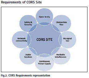
A CORS comprises of a GPS receiver and antenna set up in a stable manner at a safe location with a reliable power supply. The receiver operates continuously, logging raw data, perhaps also streaming (continuously outputting) raw data. The receiver is usually controlled by a computer that can be located remotely if necessary. The PC will usually download data files at regular intervals and pass them to an FTP server for access by the GPS user community. The first reference stations were setup along coastlines to transmit DGPS corrections to improve the accuracy of ship navigation. Today, reference stations are being established all over the world in ever increasing numbers to monitor the Earth’s crust, to provide geodetic control, to support surveying, engineering, GIS data collection, machine control and precise positioning, as well as to monitor natural and man-made structures.
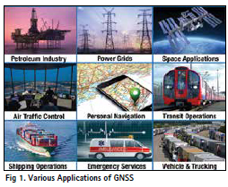
Applications of GNSS
With 506 IGS stations and 337 IGS multi- GNSS stations globally, interoperability and compatibility between the available constellations plays a vital role in achieving the best results to calculate the precise position for civil purpose.
CORS System Details
CORS Receiver Requirements:-
• Should receive from Satellite Constellations – GPS, GLONASS, Galileo, NavIC, Beidou, QZSS
• SBAS Capability -WAAS, EGNOS, GAGAN, MSAS
• Channels: 400+
• Multiple Data Logging Sessions.
• Elevation Mask/Cut-off Angle – up to 10°
• Power: 4 W
• Operating Temperature: -40°C to 65°C
Other infrastructure required
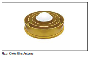
• Choke Ring Antenna:- IGS calibrated Antenna with Ground Plane, Multipath Rejection, Quality Data and Radome to protect against adverse environments like wind, rain, snow and solar radiation)
• Network Connectivity: LAN/GSM
• Data Storage Capacity:8 GB Internal, 32 GB USB/SD Card
• Uninterrupted Power, Internal Battery, Solar Panel, UPS Inverter with Battery Capacity 150 Ah
• Lightning Arrester
CORS reference system
Coordinates of CORS is in ITRF08
IGS Reference Stations – ITRF08
Space geodesy techniques – GNSS, VLBI, SLR & DORIS
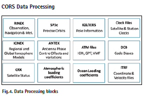
For CORS Data processing, many inputs such as RINEX, Clock files, etc required from International GNSS Service (IGS), IERS and Other Sources
Continuously Operating Reference Station (CORS) in India
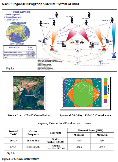
In India, CORS will be used for high accuracy positioning, geodynamics, meteorology, space weather applications [similar to SOI CORS, NOAA CORS (US), SWEPOS (Sweden)]. CORS in India could consist of network of NavIC/GNSS receivers at pre-surveyed location and connected to master server for data processing. CORS can enable high precision positioning – RTK positioning, network RTK, PPP and related applications using NavIC.(Navigation with Indian Constellation)
CORS using NAVIC has many advantages.
• NavIC is dual band (L5+S) system (and tri-band after addition of L1)
• Lower Ionospheric Errors – Dual frequency/Grid based model • Continuous coverage in Indian-sub continent
• Satellite always visible: lower probability of cycle slips
• High elevation satellites can augment other GNSS
• Accurate Code and Carrier Phase Measurements
• NavIC can provide precision positioning using RTK (PPP in near future)
• NavIC penetration is low; NavIC based RTK can be a candidate for Low cost RTK using mobile phones in Indian Region
S-band being a new band in GNSS services, there are antenna and baseband challenges, India might run a pilot project and demonstrate its usability in CORS/RTK
Challenges:-
• In-house technology development to create IP for research and industry collaboration
• S-band – new band in GNSS services – antenna and baseband challenges – cost v/s benefits
• NavIC being regional system, industry participation to be evolved
• To run a pilot project and demonstrate its usability in CORS/RTK
• Transfer technology to industry for production and operationalization at later stage
Significance of a NavIC receiver in CORS
• Multi-GNSS support in L5/S/L1
.• Provides precise code and carrier phase measurements to the network users
• Additional data – antenna phase centre, receiver phase delays, realtime location, Iono/Tropo parameters
• NavIC RTK Positioning using inhouse developed NavIC Receivers
CORS activities by various entities in India
Survey of India
GNSS technology has transformed how surveying is done. However, its use in survey applications is limited because of inherent errors associated with the GPS signals. CORS is an infrastructure that can solve the problem of accuracy and real-time data acquisition. CORS is a geo-positioning infrastructure that provides seamless, consistent and uniform framework of the country. It offers highly accurate DGPS service that also improves the speed, efficiency, and simplicity of inhouse data-acquisition process. In India, Survey of India plans to use the CORS in the construction of large infrastructure projects and in generation and up-dation of revenue maps, etc. The system will also augment with the NAVIC network along with other GNSS networks like GPS, Galileo and GLONASS. In future, with the NAVIC system, dependence on foreign satellite systems will be reduced, making India a self-reliant nation.
Council of Scientific and Industrial Research [CSIR]
CSIR Fourth Paradigm Institute [CSIR- 4PI] is working on GNSS /NAVIC for CORS —-Application and Positioning
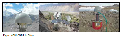
CSIR-National Geophysical Research Institute [NGRI], Hyderabad has undertaken the following activities- “Understanding geodynamics and earthquake processes through crustal deformation measurements using CORS GNSS”
GPS measurements were done in various parts of Himalayas. Crustal deformation and seismic hazard in the Indo-Burmese
Arc were studied. The other activities are Study of Co-seismic offsets, ionospheric disturbances and rupture modelling.
Academia
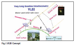
i. National Centre for Geodesy, Indian Institute of Technology Kanpur (estd. with support from DST, Govt. of India) has done Geodetic VLBI studies for Realization of ITRF and Estimation of Earth Orientation Parameters (EOPs)
ii. Electronics Engineering Department, Sardar Vallabhbhai National Institute of Technology, Surat, India in collaboration with SAC, ISRO has done the following studies.
a. Intentional and Un-intentional Interference Effect on NavIC such as
▫ Jamming Interference Study and observations
▫ Wi-Fi Interference Study and observations
▫ Ionospheric Error Study and observations
b. “SIRMI – Strengthening IRNSS receiver by Mitigation of Interference”.
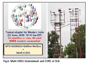
iii. GNSS Laboratory, University of Burdwan [GLB]
GLB has studied the experience of GNSS PPP using geodetic and low-cost, compact receivers. A CORS at GLB operating 24×7 used online PPP service (AUSPOS) to find out the precise antenna coordinate and is being used as the RTK BASE Station. Experiment was performed to find out best time to obtain precise NavIC based SPS from 2 places of West Bengal; Concurrent NavIC L5+S data were collected.
CORS activities by ISRO
Coming to technology front, high precision geodetic grade NavIC/GNSS receiver is key component of CORS. Receiver antenna to be installed at pre-surveyed location to get full sky view, free of multipath and interference free environment
i. Space Applications Centre, ISRO has carried out work on code and carrier phase based precise positioning algorithms and software in differential mode using NavIC L5 signals, positioning software in real-time.
A prototype version of the NavIC based PPP engine is under development at SAC in collaboration with Academic Institution [Nirma University]
The challenges in receiver/algorithm development such as
• RTK using NavIC for short baseline to very long baseline
• RTK solution in multipath, canopy, semi-urban and urban
• Geodetic grade Tri band antenna
• Development of NavIC PPP receiver
• Development of RTK receiver capable of precise Positioning with advanced algorithms
are being addressed by SAC, ISRO.
ISRO has a Roadmap :-
• Proof-of-Concept NavIC CORS network for a limited geographical area
• Evolution of country-wide network of CORS in collaboration with all stakeholders
• Robust and reliable communication network
• NavIC RTK Positioning to be demonstrated using indigenous NavIC Receivers
• Develop techniques in NavIC receiver to overcome jamming, interference and spoofing
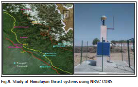
ii. National Remote Sensing Centre (NRSC), ISRO is doing research on GNSS application in geodynamics studies such as crustal deformation monitoring, monitoring the Central Seismic Gap, generation of monthly dynamic hazard maps etc. NRSC has constructed 8 GNSS CORS Stations along major Himalayan thrusts belts within the central seismic gap. NRSC is also processing data from CORS data of GAGAN Indian Reference Stations [INRES]. Computation of velocity of Indian plate done from 10 Stations & 3 streams of GAGAN INRES data. As part of EOAM Project “GPS & GAGAN/IRNSS data analysis for Intra-Plate Geodynamic Profiling in Active Seismic Zones”, Himalayan thrust systems were monitored
International GNSS Service (IGS)
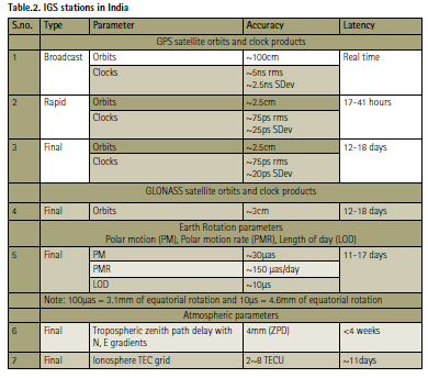
International GNSS Service is a voluntary federation established in 1994 as a service of the International Association of Geodesy (IAG). It ensures open access (400+ worldwide stations) high quality GNSS data to scientific community and commercial applications. With a global network of more than 500 GNSS ground stations, IGS provides the highest-quality GNSS data, products and services. Currently IGS provides precise products for following constellations: GPS, Galileo, GLONASS, Beiduo, QZSS and SBAS
The following products are derived:
• Orbit
• Clock(Sat/Rx)
• Station Coordinates and velocities
• Tropo and Iono products
• Earth Rotation Parameters
IGS also provides CORS data. However, it has a global scope. The information on the individual stations can be accessed including the ITRF Cartesian coordinates and velocities for the IGS sites, but not all the sites are available from IGS servers.
The IGS products contain the following files:-
a. GNSS satellite ephemerides (.sp3 files)
b. Earth rotation parameters (.erp files)
c. Global tracking station coordinates and velocities (.snx files)
d. Satellite and tracking station clock information (.clk files)
e. Zenith tropospheric path delay estimates (.zpd files)
f. Global ionosphere maps (.ion files)
The following are the guidelines for IGS stations :-
The Station must be planned and installed for continuous and permanent operation. 5˚ is the elevation cut-off. GNSS receivers must be set to track as many satellites, healthy and unhealthy (all-in-view tracking), from as many constellations as possible (within receiver limitations), always including all GPS satellites as a minimum. The station’s GNSS antenna absolute calibration must be available in igs14.atx. The Station’s data handling and transmission to the relevant Data Center must occur reliably as scheduled. After a communication outage at the station, the data over the outage must be uploaded to the Data Center.
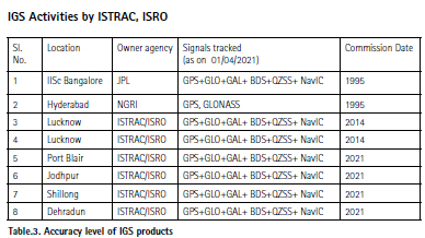
ISTRAC, ISRO has installed NavIC enabled IGS stations at Lucknow [2 stations], Port Blair, Jodhpur, Shillong and Dehradun. All these are operational and 4 of them are in APREF network [ Asia Pacific Reference network] managed by GeoScience Australia.
With the inception of NavIC, NavIC based applications are proliferating rapidly in the civilian domain. NavIC messaging receivers are being provided to fishermen community via the state fisheries departments. Vehicle location tracking devices with NavIC capability are being mounted on public and commercial vehicles meeting the mandate set by the government. NavIC timing receivers are being employed for dissemination of time, including dissemination of the Indian standard time. Other applications like asset monitoring, industrial IoTs, scientific studies, etc. are also picking up rapidly.
The applications are constantly driving the need for better precision and higher accuracy from the NavIC receivers. These applications rely on technologies like differential NavIC, RTK and PPP for the requisite precision and accuracy. To achieve this, we need to enable precise orbit determination capability for NavIC satellites through the vast network of IGS stations.
Applications of IGS Stations
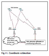
1. Precise Coordinate estimation
2. Study of Crustal dynamics
3. Ionospheric irregularities measurement
4. Tropospheric modeling
IGS stations provide critical data for earth science, atmospheric science and navigation. The Indian-Eurasian-Australian Plates are moving at different relative velocities leading to compressional regimes at their margins leading to seismicity in these zones. Also, the coordinates of any geographical location experience a shift over the course of time due to tectonic plates movement and crustal dynamics.
Addition of IGS stations provide an advantage of fixing coordinates of all antennas, in the vicinity, within a level of 1cm accuracy besides providing data to international community for geodetic research and atmospheric study. As both Lucknow and Port Blair are in earthquake prone areas and are strategically located, they are not only critical elements for ISRO as well as for the Science community. The addition of NavIC L5 signal will help in calibration of the antennas’ coordinates in the vicinity of the IGS station using NavIC data in addition to the other existing GNSS. Establishment of more NavIC enabled IGS stations is being planned within and outside the country as suggested by CORS.
Need of NavIC enabled IGS :-
The widespread IGS network will provide appreciable improvement in measurement database for NavIC system. This measurement data available at NavIC Control Center can be used to generate high accuracy broadcast navigation parameters using NavIC POD software. The advantage will be that NavIC primary navigation users (real time and offline) will be directly benefitted by this in addition to users through IGS. Establishment of NavIC capable stations in IGS network will aid the IGS user community and IGS products can be generated through POD for end user applications by IGS team.
UR Rao Satellite Centre is working on Precise product generation for NavIC constellation using wide spread geodetic Rx
Acknowledgements:
1. Priyom Roy, NRSC, ISRO
2. Dr Anindya BOSE, University of Burdwan
3. Maj Gen (Dr) B Nagarajan, IIT Kanpur
4. Nirmala S, UR Rao Satellite Centre
5. Neelu Kasat, ISTRAC, ISRO
6. Dr. Sridevi Jade, CSIR-4PI
7. Dr.S.K.Singh, Survey of India
8. Vineet.K.Gahalaut, CSIR-NGRI
9. Dr. Shwetha.N.Shah,SVNIT
10. J.Narendran, NRSC-ISRO
11. Ghanshyam.J.Doshi, SAC-ISRO
12. Nishkam Jain, SAC-ISRO


 (2 votes, average: 4.00 out of 5)


Leave your response!