|
NSDI is also facing several challenges in the areas of accessibility, availability, institutional arrangements, lack of standards and experts
|
|
 |
Hayder Abd Al-
Razzaq Abd
|
Department of Civil,
Faculty of Engineering,
|
UPM University,
Serdang, Malaysia.
|
Department
of Surveying, Faculty of Engineering,
|
University of Baghdad, Iraq
|
|
|
 |
Abdul Rashid Bin
Mohamed Shariff
|
Geospatial Information
|
Science Research
Centre (GISRC),
|
University Putra
|
Malaysia, Malaysia
|
|
|
|
Bal Krishna
|
Coordinates, India
|
|
|
|
Spatial Data Infrastructure (SDI) consists of Global Positioning System (GPS), Geographic Information System (GIS), Remote Sensing (RS), and the procedures and tools for creating, sharing, and integrating the SDI. The accessibility to SDI as input variables for many project plans and implementation reflects the effectiveness of using SDI. It is created throughout the world by several countries at all level (governments, private sectors, national, state, province and region) (Rajabifard et al, 2003). SDI is encompassed framework policies, standards, network accessibility (technologies), fundamental datasets and human resources (users and the datasets providers) (Feeney et al, 2002; Rajabifard et al, 2006). It is developed from local level to state/province level, then national and after that at global level. Building and implementation of SDI is not only concerned with technology but also concerned with policies and obtaining of new skills (Feeney et al, 2002; Foresman et al, 2004).The goal of these attempts, as mentioned by Masser et al, (2007) is to raise the economic development to create better government to support the environmental and business needs. National Spatial Data Infrastructure (NSDI) is the best solution to spatial data between different organizations (Pulusani, 2004; Williamson et al, 2007). NSDI comes from technology, standards, criteria and the people that create access and share the spatial data throughout all levels (private sector, non-profit sector and government agencies). It represents the base structure of the relationship between those who use and deal with spatial datasets and data providers (users and data producers). NSDI represents new technology to share, access and use the spatial data. This is very useful for analyzing and processing, and then using the output to help in the process of decision-making (Clinton, 1994; Coleman et al 1998).
NSDI elements
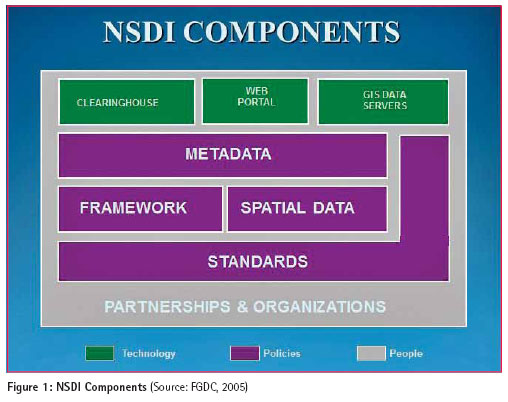
Many researchers and agencies have generated their own NSDI elements depending on their objectives, work vision, priorities and requirements at a national level. For example, the federal geographic data committee (FGDC) created its own NSDI with six basic elements. These elements are (clearinghouse, geospatial data, partnerships, geo-data metadata, standards and framework), as shown in figure (1) (FGDC, 2005; Masser, 2002). Tosta (1995) established its own NSDI model with four elements. They are geospatial data clearinghouse, standards of geospatial data, framework data and partnership. On the other hand, the Australia New Zealand land information council created its own NSDI with four elements, and these elements are – framework, standards, fundamental datasets and clearinghouse (Masser, 2002; Anzlic, 1998). The permanent committee on GIS infrastructure for Asia and the Pacific has considered the same elements as of the Australia New Zealand land information council NSDI (PCGIAP, 1998). It considers interaction between the human resources and the NSDI important as the human resources involve in the NSDI framework. Human resources are considered as a key in collecting, managing, controlling and analyzing the datasets of NSDI. Rajabifard et al,(2001) also suggested that the NSDI includes more than four elements that are described by Anzlic, therefore, we should add another component to NSDI elements. This element is human resources. Crompvoets, (2006); Rajabifard et al, (2002) demonstrated these categories could be changed, for example, both data and human resources could be combined into one category related to the relationship between them. Technologies that consist of (clearinghouse, policy and standard) are considered as the second category. This category controls the first one.
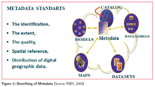
Metadata
The meaning of Metadata is a file that has a format (XML) document that describes the content, quality and type of the data. In other words, it is the information used to describe data and its services. The spatial data Metadata usually documents data related to the Geographic Information System (GIS), Geo-spatial datasets, satellite images, and also characterized Geographic component, such as information about projects projection and attribute. Metadata needs to develop many procedures to implement a seamless mechanism for all users of spatial digital data. Spatial Metadata is very important to serve the NSDI. Throughout the world, the users of NSDI have been utilizing the Content Standard for Digital Geospatial Metadata (CSDGM). The standards or policies of international Metadata should have the legacy and merge in community (FGDC, 2005), as the figure (2) below describes the Metadata.
Standards
In order to facilitate using, sharing, developing and transferring the national geospatial data, there is need to find standards to arrange and manage all spatial data aspects – metadata, dictionaries, quality, models, and transfer (Anzlic, 1998; FGDC, 2005). Many sources provide data. Each one generates its own data based on its own needs, standards and requirements that will obviously be revealed when sharing the data by using the clearinghouse. Most of the SDI data have different standards and structures. From this point, the users need access to unique standards to make the spatial data easy to share between different users at national level, and to increase the consistency of data. For example, the FGDC in the US developed data standards for sharing, cooperation and implementation of NSDI at different levels; local, province, state, nation and region between the government agencies, academic communities and private sectors. The FGDC generated these standards based on the OMB Circular A-119. (FGDC, 2005).
NSDI Clearinghouse Network
NSDI clearinghouse is a server to describe, advertise, distribute and supply the geospatial data. The data suppliers publish their own metadata that characterize the data, quality of data and accessibility. The host organizations collect the metadata to advertise and characterize their own geo-spatial data within the NSDI. These metadata provide the users a quick and good assessment of available SDI (Anzlic, 1998; FGDC, 2009), as figure (3) demonstrates the search and retrieve mechanism inside the clearinghouse and below is the explanation of the steps of this mechanism:
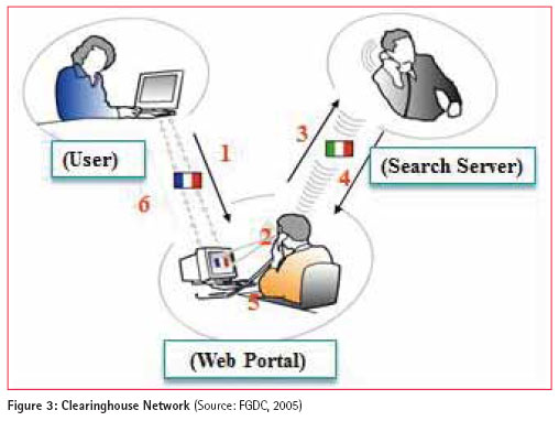
1) Users using the ability of communications like email and phone to send some questions by using HTTP/HTML to the web portal;
2) Using Z39.50 the web portal will translate the request;
3) Send the request to search server;
4) Search Server will responds to the web portal by using Z39.50;
5) Converting responds to HTTP/HTML; and
6) Sends back to the user.
People (Partnership)
The components of NSDI are based on a partnership. In another words, the cooperation that occurs between all those involved into processing of NSDI. Also in spatial data community, the ability of data sharing, developing and maintaining standard datasets will be increased by the relationships that are created by NSDI (Tosta, 1995). In addition, people will make the decisions, and all these decisions require data to be retrieved in a good and right manner. Without people data will not exist. So, the dealing with concepts of data sharing, data accuracy and data accessibility are dependent on the relationships between the people. The activity of the NSDI model will increase the relationships (Rajabifard, 2001).
Institutional framework
The institutional framework is collaborative, dependent on efforts in which the data are collected, developed, modified and integrated by different sectors of private and government organizations within the same geographic area. The frameworks are important for building data factors of SDI. In US, the representatives of country, state, region, nation and other organizations under the federal geographic data committee (FGDC) they have been developed on the concept of a framework. And most of providers and users of NSDI in local, province or region level admit that the framework is the better way to improve, share and manage the SDI, and it makes the data efficiency at the highest level. There are three aspects of framework – technology, procedures and data. The framework has been used to make the use of geo-spatial data or its products more easy to help the user in making decision and make the cost of getting NSDI at a satisfying level (FGDC, 2005).
Challenges and issues of NSDI
NSDI was introduced in 1994. It is important to understand these issues and also discuss the implications of these constraints.
Digital data availability
The governments’ agencies develop, controll, generate and manage different types of spatial datasets. The accurate geo-spatial data should be available at different levels to be utilized for economic, environment and social growth and national development. Availability of the accurate spatial data will enable the decisionmakers to take right decisions. In addition, it will also decrease the efforts and the cost of data generation by minimizing the data duplications. However, some of the data are not available. Ready dataset framework is very essential, particularly the topographical maps, which are used in providing the basis for several spatial data that will be used by government agencies or private sectors. And many times, many of the datasets are not available in digital forms. Non-availability of data in digital form can be one of the difficulties in the implementation of NSDI. Data in digital form will make it easier to share the spatial datasets between the organizations, especially those using technology such as the Internet (Sen et al., 2006).
Digital data accessibility
Most government agencies and private sectors finally recognize the advantages of having accessibility to geo-spatial datasets of others. The financial aspect is the biggest issue which has to be considered in many processes, such as (sharing cost, accessing data and services). The access mechanism is completely based on standards of accessibility and sharing the data. Standards, transfer procedures, and the system are considered as the important factors in NSDI implementation. The continuity of progress in NSDI is related to the issues it faces and affected by successful accessibility to the data. But still there are some constraints when it comes to sharing the data, and these constraints are related to institutions and organizations’ aspects to customize the policies for sharing data. (GINIE, 2004).
Adoptions of standards
Sharing the spatial data faces several constraints, but the major ones are those that lack of national standards to arrange sharing the spatial data, inconsistency in classification and absence of documentation of spatial data (metadata). The spatial data should have common standards to make the integration of data easy with other datasets. This integration allows availability of effective and efficient solutions for people who use or are concerned with this kind of data that will lead data providers to make the data available via NSDI. Identification of priorities will foster consistency of spatial data to match the users needs. Development of geo-database can be easy considering common systems, spatial referencing system, standards and models. In many cases, the temporal resolutions and spatial coverage area, formats and projection coordinates of maps are incompatible. The technical constraints are matching different standards and communicating between the complex standards. Adopting standards leads to focus on documenting the quality of the spatial datasets and the interoperability. (Noor H. et al., 2010; Rajabifard, 2003).
Availability of metadata
The availability of Metadata is another issue that challenges the development of NSDI. It is a serious issue, as many users do not have the ability to know the content of this data without metadata. Generation of metadata must be given the highest level of priority. The data that has metadata becomes more informative and has good quality. ISO19115 – is one of the famous standards of metadata that has been proposed recently, and it became an international standard for geo-spatial datasets. However, several government agencies and private sectors have suggested different types of metadata profiles. (Minh et al, 2009; Sen et al, 2006).”
Data interoperability
Data interoperability is considered as an important issue among the processing and utilization of spatial data. Many of the spatial data that are collected by different organizations and private sectors are incompatible as they are collected by using different standards though they are of the same area. There is a strong requirement for interoperability for many applications, especially with the applications that are related to municipality and government.
The geo-spatial datasets have to be seamless data as far as possible. Almost all national data that are collected, stored, processed, analyzed and maintained without considering spatial standards (National) that generate other difficulties with the data. When users need to integrate them together, there is no interoperability between the data (Minh et al, 2009).
Institutional arrangements
Sharing the spatial data is linked to authority and hierarchy in almost all the government agencies, organizations and private sectors. There is no truthful attempt to share the spatial data among various sectors. Each government agency or private sector undertakes their mandate attempting to generate their own spatial database system by following their needs and priorities. The spatial data is used in vertical dimension and hierarchy (NALIS, 1997; Noor H. et al, 2010).
Lack of awareness in NSDI and GIS
Lack of awareness is a major problem in implementation of NSDI. The majority of spatial data users and producers are not very familiar with using SDI, and that is simply because the channels communications between them and NSDI is still at a generating level not widely known to them. By increasing the level of awareness among the SDI users it will help establish implementation of NSDI with high level of benefits from its products(NALIS, 1997;Arshad et al, 2010).
Lack of knowledge and skills
Successful development and dealing with all NSDI elements into organizations requires skills, knowledge, and know-how about how much should be obtained outside assistance. Many times, there is a lack of experience and knowledge in GIS. Thus, there is a need to focusing on the capacity building of NSDI staff through training programmes to meet the requirements skilled manpower. Understanding and applying of capacity building in implementation of NSDI will assist the agencies to boost the progress of NSDI development and its implementation. (Minh et al, 2009; Arshad et al, 2010).
Difference in languages
NSDI management faces many problems. The difference in languages is one of the important factors that affects the management of NSDI. The NSDI must have a support system that is able to deal with multi variables in any language that is involved in the system. However, the difference in languages fosters challenges that not considered as a part of NSDI management processing. Users often use translation ability, when they are looking for novel or modified functionality to coordinate the processing of translation. The web application brings many multilingual problems, for example, catalog services have to be supported by language data retrieval. There are several geo-spatial datasets resources that have been cataloged by one language. On the other hand, the users make queries in another language. These users could be interested in some kind of data (documents, images, and database) described in another language to them. So, the catalogs should supply the users mechanisms search that give them the ability to overcome the problem to describe the data in different languages. The problem of multilingual will cause difficulties in doing any search, collection, analysis and processing of data and that will have a big influence in performing of NSDI (Alhubail, 2004; Minh et al, 2009;Arshad et al, 2010).
Poor cooperation
Cooperation is mostly a factor that can push forward the implementation of NSDI. The more cooperation it receives, the more successful will NSDI be. Some of the projects of NSDI will be implemented with multi stakeholders when the partnerships have geo-spatial datasets that can make the NSDI project a success. (GINIE, 2004; Manisa et al, 2007; Minh et al, 2009; Arshad et al, 2010).
Partnership arrangements
Using and sharing of geo-spatial datasets normally occurs among governments agencies and private sectors, but they do not share the responsibilities of generating, maintaining, and distribution of the spatial datasets. The cost of all these processes should be justified in terms of public advantages. The access arrangement of NSDI spatial data should have a high confidentiality, high level of security, privacy and intellectual property rights (IPR). Considering the agreement the partners have to contribute in the costs accrued in collection, analysis and management of the geo spatial data, and should integrate the output of these data in their database to be distributed to their users or customers. They should make or try to make harmonious terms and standards between them (Manisa et al, 2007; Arshad et al, 2010).
Policy and legal issues
An appropriate policy framework that encourages and facilitates the easy access to spatial data can be a key for the success of any NSDI initiative. In addition, legal issues pertaining to intellectual property rights, copy rights, ownership, liability, etc should be clearly defined.
Absence of technology infrastructure
Many countries around the world suffered from the deficiency of the technology like Service (WFS), Architecture, Web Feature, Web Map server (WMS), and Clearinghouses, etc. Sharing any type of spatial datasets will be with using these technologies. The lack in technologies is a negative factor that affects in the sharing of data among different types of organizations and agencies (Sen et al, 2006; Minh et al, 2009).
Funding limitation
There is a clear limitation in the resources that use and analyze the geospatial datasets among the geo-spatial data agencies. Any spatial projects or applications needs massive and various types of data for conduction stages. The users must get this kind of expensive hardware and software to obtain accurate results. Hence, providing any type of spatial datasets to solve any scientific problem and social problem, the factors related to the expenses have to be overcome. Therefore, few private sectors and organizations can carry out this work. The key element of different spatial datasets products and services is that the thematic data that has been used in different disciplines such as industries or in societies. The customers require specific data to meet the requirements of the decision making, planning and processing needs. Users should buy the products to get all these data. (Minh et al, 2009; Arshad et al, 2010).
Public private partnerships
To create NSDI, cooperation between all kind of parties is important to know and realize its potential. All parties of NSDI should arrange and define the responsibilities among them. The public sector should carry out the responsibility of standard, legislation and policy. However, public and private sectors work together for developing and designing the infrastructure, and both of them work to mark the NSDI services and develop technologies of the NSDI initiative. (Minh et al, 2009; Arshad et al, 2010).
Conclusion
SDI can create a successful environment for both stakeholders and decision makers to achieve goals at different levels (administrative or political) when they both cooperate with their work, share their achievements, and use technology that will improve their work without wasting time and cost. Recently, SDI has been employed in many countries throughout the world due to its importance, and was employed across different levels (global, regional, national, private sectors and other organization). NSDI faces several challenges in its implementation. NSDI gives the opportunity to share data, avoid wasting of time, efforts and the resources that lead to duplication of work, in order to achieve the same result (data) among different agencies or government departments.
References
Alhubail, S. S. (2004). Framework Data Modeling For The Proposed National Spatial Data Infrastructure Of United Arab Emirates (p. 239). Canada.
Anzlic. (1998). Spatial Data Infrastructure for Australia and New Zealand. Discussion Paper, at, http://www.Anzlic.org.au/, [accessed 14 September 2012].
Arshad, N. H., & Hanifah, F. A. B. U. (2010). Issues and Challenges in NSDI Implementation. Proceedings of the 9th WSEAS International Conference on System Science and Simulation in Engineering (pp. 65-70). Japan
Clinton, B. (1994). Coordinating Geographic Data Acquisition and Access: The National Spatial Data Infrastructure. Federal Register, 59(71), 1-4.
Coleman, D. & McLaughlin, J. (1998). Defining global geospatial data infrastructure (GGDI): components, stakeholders and interfaces. Geomatica, 52(2), 129-144.
Crompvoets, Joep. (2006). National Spatial Data Clearinhouses Worldwide Development and Impact. PhD Thesis. Wageningen University, Wageningen
Feeney, M., Rajabifard, A., Williamson, I. 2002. Future Directions For The Development Of Spatial Data Infrastructure. International Journal of Applied Earth Observation and Geoinformation. Vol. 1: 1–12.
FGDC. (2005). Components of the NSDI. at http://www.fgdc. gov/components, [accessed 12 November 2012].
Foresman, T. W. (2004). Progress with the Digital Earth Global Infrastructure. Paper Presented at 7th GSDI Conference, 2-6 Feb 2004 India, at, http://www. gsdidocs.org/docs2004/stratim. html, [accessed 14 January 2011].
FGDC. (2009). NSDI Clearinghouse Network., at, http://www.fgdc. gov/dataandservices, [accessed 24 October 2011].
GINIE. (2004). GINIE: Geographic Information Network in Europe. Rowards a European GI strategy; Lessons Learnt from GINIE (p. Report D 1.5.1). UK, at, http://www.ec-gis. org/ginie/doc/GINIE_finalreport. pdf, [accessed 18 November 2012].
Masser, I. (2002). Report on A comparative analysis of NSDI ’ s in Australia , Canada and the United States. October (p. 9). UK., at, http://www.ec-gis.org/ginie/doc/ SDIComparative_report_Final.pdf, [accessed 15 November 2001].
Manisa et al, (2007). Developing Botswana Spatial Data Infrastructure : From Concept to Reality. FIG working week: Strategic Integration of Surveying Services,at,http://www. fig.net/pub/fig2007/papers/ts_1d/ ts01d_04_manisa_nkwae_1376. pdf, [accessed 23 October 2012].
Masser, I.(2007). The First Generation of National Geographic Information Strategies. Paper presented at the Third Global Spatial Data Infrastructure Conference, Canberra, at, http://gsdidocs.org/ docs1998/canberra/masser.html, [accessed 21November 2012].
Minh, H. T. (2009). Current status and challenges in establishing NSDI in Vietnam. Applied Geoinformatics for Society and Environment (AGSE). Stuttgart, Germany: 1-13.
Noor H. et al,.(2010). Issues and Challenges in NSDI Implementation 9th Wseas International Conference on System Science and Simulation in Engineering. (ICOSSSE’ 2010), Iwate, Japan October 4-6: 65 – 70.
Nalis, (1997).Public Service Progress Circular. Guidelines for The development and implementation of National Infrastructure for Land Information System (Nalis), 1997.
PCGIAP. (1998). A Spatial Data Infrastructure for the Asia and the Pacific Region. PCGIAP publication No. 1. Canberra.
Pulusani, P. 2004. Enabling Interoperable Spatial Data Infrastructures for Sustainable Development, Intergraph Mapping and Geospatial Solutions. Proceedings of the Global Spatial Data Infrastructure Conference.
Rajabifard, A. (2001). Spatial data infrastructures: concept, SDI hierarchy and future directions. Proceedings of GEOMATICS (p. 10). Australia, at, http://www.irpds.com/FileEssay/ joghrafi-1386-11-29-agh(2).pdf, [accessed 10 November 2012].
Rajabifard et al,. (2002). Diffusion of Regional Spatial Data Infrastructures: with particular reference to Asia and the Pacific. PhD_Thesis, The University of Melbourne, Melbourne,Australia.
Rajabifard, (2003). A. Developing Spatial Data Infrastructure: Highlighting Issues and Influencing Factors. Paper presented at 16th United Nation- Regional Cartographic Conference for Asia and Pacific (16th UNRCC-AP) , Okinawa Japan.
Rajabifard, A., Binns, A., Masser, I. & Williamson, I.( 2006) The Role of Sub-National Government and the Private Sector in Future Spatial Data Infrastructures. International Journal of Geographical Information Science,. 20(7): 727-741, at, http://www.geom. unimelb.edu.au/research/publication, [accessed 9 October 2012].
Sen, S., Somavarapu, S., Sarda, N. L., & Sivakumar, R. (2006). Schema Matching as a step towards Interoperability : Experiments in the Indian NSDI. Beyond Spatial Data Infrastructures International Workshop at the GIScience (p. 6). Münster, Germany.
Tosta, N. (1995). Data Policies and the National Spatial Data Infrastructure. Law And Information Policy For Spatial Database. FGDC, at, https:// sites.google.com/site/gissinan/ student-of-the-month/johndoe, [accessed 17 October 2012].
Williamson, I., Rajabifard, A., Holland, P., & Johnstone, G.(2007). From local to global SDI initiatives: a pyramid building blocks. Proceedings of the 4th GSDI Conference, 2000. Cape Town, South Africa, at, http://www.geom. unimelb.edu.au/research/publication, [accessed 2 October 2012]. |


 (9 votes, average: 1.89 out of 5)


Leave your response!