|
This research explored the possibility of combining the GAGAN (SBAS) with IRNSS. In addition,
with new messages included, the proposed SBAS can also transmit the corrections for IRNSS
|
|
 |
Vyasaraj Guru Rao
|
University of Calgary,
|
Canada & Accord
|
Software & Systems Pvt Ltd,
|
Bangalore, India
|
|
|
 |
Gérard Lachapelle
|
Professor of Geomatics Engineering,
|
University of Calgary,
|
Canada
|
|
The Indian Spa ce Research Organisation (ISRO) is in the process of deploying the Indian Regional Navigation System (IRNSS), a dual frequency service system. Another contribution by ISRO in the area of Navigation system is GPS Aided GEO Augmented Navigation (GAGAN), an augmentation system. Till date, to the best of authors’ knowledge there is no work that has explored the potential synergy between IRNSS and GAGAN. An article in the previous edition (Coordinates Feb 2011) showcased some research work where new locations were suggested for IRNSS satellites to enhance its regional coverage. Based on the proposed locations, this research presents an engineering synergy between IRNSS and GAGAN and highlights its distinctive merits.
To begin with, a brief introduction to GAGAN and IRNSS is presented from a signal’s perspective. Following this, the optimization criterion used in this research is deduced. The main factors affecting optimization are elaborated in detail with the optimal constellation deduced. Finally, the merits of the proposed constellation are discussed in detail.
GAGAN
The void SBAS foot-print between EGNOS (Europe) and MSAS (Japan) is established by GAGAN. The following section describes the control and space segment components that make GAGAN operational.
The GPS satellites visible over the Indian subcontinent are continuously tracked at several monitoring stations. The stations are equipped with state of the art reference (survey grade) receivers that provide precise estimates of pseudoranges, carrier phase measurements and time information based on dual frequency. The stations also have the antenna located at a surveyed location. In addition, these receivers provide estimates of satellite related anomalies (for example, Signal Quality Monitoring (SQM)), if any. With these inputs and traits, measurements are formulated. Further, the integrity stations are spread across the Indian land mass (to obtain the ionosphere data for modelling), which relay the data to the master control station located in Bangalore. Based on the collated data from various stations, the messages are generated as per SiS requirements of SBAS (DO- 229D 2006). These structured messages are uplinked in C-band to the GAGAN satellites as shown in Figure 1 a). ( (GAGAN Architecture 2012), (Ganeshan 2012)).
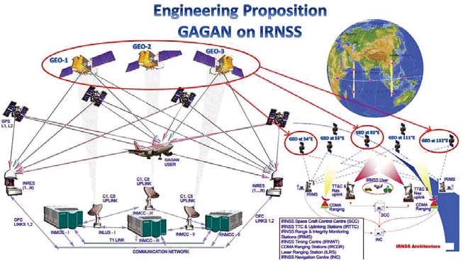
F igure 1: Control and space segment architectures of a) GAGAN b) IRNSS.
GAGAN will have three geostationary satellites when fully operational with the signal footprint spanning over the Indian subcontinent (Kibe & Gowrishankar 2008). Points noteworthy of this signal are:
• transmitted in L1 band at 1575.42 MHz
• transmitted at -160 dBW, similar to GPS L1 C/A
• codes used are from the GPS L1 C/A family
• basic data rate is 250 Hz
• rate ½ 7 bit Viterbi encoding is employed on data bits and thus effective symbol rate is 500 sps.
• GPS receiver accuracies achievable over the Indian land mass with this signal will be similar to that achieved over the US with or without WAAS.
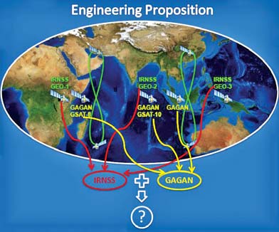
Figure 2: GAGAN (GEO-3 position assumed) and IRNSS geostationary satellites.
From the above points, it is clear that the signal (data) is transmitted fi ve times higher than the GPS L1 C/A (ISGPS- 200E 2010) but its power has not been increased. This can be attributed to the following reasons:
• First, to achieve similar performance to L1 C/A (w.r.t measurement accuracies), 12 dB additional power would be required. This would act as in-band jammer and lift the noise fl oor of the GPS L1 channels (Parkinson & Spilker 1996).
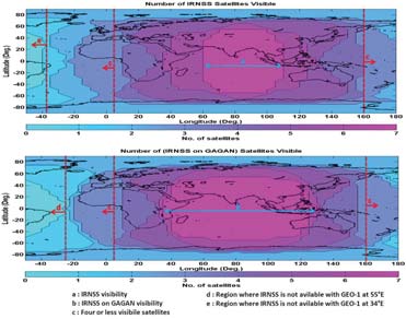
F igure 3: Satellite availability with current IRNSS and proposed IRNSS constellation
• Second, to accommodate the above requirement, the absolute power required would be -148 dBW, which violates the guidelines for space based signal transmission (Singh et al 2008). Thus, with -160 dBW the ranging measurement performed on SBAS will be relatively inferior to GPS L1 (Parkinson & Spilker 1996). This not being a system objective, SBAS focusses on providing integrity messages and can effectively be interpreted as a data channel.
IRNSS
As a second initiative in the space based navigation, IRNSS is ISRO’s other contribution with an objective to provide independent regional navigation to cover its territorial footprint and slightly beyond. The system is expected to be operational by the end of 2015 (Bhaskaranarayana 2008). The system of space and control segment for IRNSS is as shown in Figure 1 b) (IRNSS Architecture 2012). The top level details of the control and space segments are as follows:
Similar to the GAGAN control segment, IRNSS Range Integrity Monitoring Stations (IRIMS) will be deployed at several places spread across the Indian subcontinent. These stations will be equipped with high end receivers which will provide all relevant information about the satellites. With the signal transmission from the fi rst satellite, these receivers will perform measurements and collect the NAV data. The data will be relayed to the master control station located in Bangalore. Based on this data, batch (typically) processing will be performed to generate the Keplerian parameters of all the satellites, the clock correction terms and the secondary NAV data information. Unlike GAGAN, this is a complex activity that determines the overall system accuracy (User Equivalent Range Error (UERE) (Rao et al 2011). The data generated is uplinked to IRNSS satellites.

The space segment will have a total of seven satellites, four in geostationary and three in geosynchronous orbits (Bhaskaranarayana 2008). Some features about IRNSS signals available from open sources are:
• The IRNSS L5 and S1 will transmit signals for civilian/restricted operations (Kibe & Gowrishankar 2008).
• There will be a total of seven satellites, three in geostationary and four in geosynchronous orbit as shown in Figure 1 b).
Optimization
From a regional perspective, it is clear from Figure 1 that there will be six payloads on six geostationary (3 each of IRNSS and GAGAN) satellites serving the navigation needs centered over the Indian subcontinent in the near future. From a system perspective, an obvious engineering optimization w.r.t the number of satellites is evident from Figure 2 constrained by the individual specifi cations of each system. Optimization w.r.t reduction in the number of satellites being the objective, the following section proposes to reduce the satellite count, yet fully meet the IRNSS and GAGAN functionalities and fi nally deduce a simple third frequency option for IRNSS.
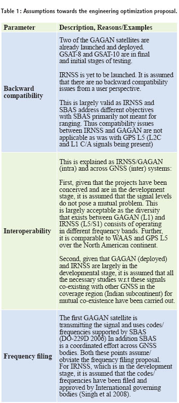
To begin with, the assumptions made for the optimization are presented in Table 1. These assumptions are for the signals (GAGAN, IRNSS, and (GAGAN+IRNSS) w.r.t GNSS) over the Indian subcontinent. The attributes enumerated in the assumptions are backward compatible – which is applicable when a new system in proposed with a system already operational, interoperable – that is mutual existence of two systems and Frequency fi ling – which is a pre-requisite before a signal is transmitted from the satellite.
With the above assumptions, it is evident that the systems can be integrated without too many external issues and only constrained by the resources on the satellites. Based on the research work published in (Co-ordinates Feb 2013), the constellation as listed in Table 2 is proposed for IRNSS and GAGAN.
Advantages
The merits of IRNSS on GAGAN are explained as follows:
Availability
Availability from the proposed IRNSS is drastically enhanced (Coordinates Feb 2013). In addition, from Figure 3, it is very clear that the GAGAN coverage area is signifi cantly enhanced, which is the polygon b. This is nearly a 60% increase in the coverage of GAGAN service volume
SBAS & high dynamics
As mentioned in the earlier section, with the success of GPS and the need for correction/integrity, the SBAS program emerged. A similar proposition might arise in future for IRNSS. With few additional messages exclusively for IRNSS, GAGAN can be modifi ed to account for the IRNSS’s SBAS corrections as well. Through textual data (for example, some SBAS messages for IRNSS can be supported and, due to the inherent data rate limitations (50 Hz) and the need for some of the messages to be fast (for example, fast correction messages of SBAS), dedicated medium is required. This can be easily handled by additional messages onboard GAGAN (for example, GLONASS SBAS messages transmitted in EGNOS in addition to GPS (EGNOS 2011).
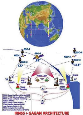
Fi gure 4: Proposed IRNSS+GAGAN constellation.
Higher user dynamics require wider Doppler search ranges. This coupled with high data rates (500 sps) puts a constraint (sensitivity) w.r.t SBAS acquisition in standalone mode (for example, no estimates of position, velocity, almanac or time). With the integrated proposal, IRNSS satellites when tracked in L5/S1 can directly assist L1 (SBAS) and thus improve performance drastically w.r.t acquisition in high dynamics.
Satellite count
An obvious advantage with this approach is that GAGAN satellites with IRNSS frequencies will eliminate three IRNSS geostationary satellites. Unlike GAGAN, IRNSS are dedicated navigational satellites. Assuming a pessimistic estimate of 100 million USD/satellite including launch, a signifi cant reduction in the cost is achieved (300 million USD in all) with the proposed integrated architecture. At the same time, the specifi cations of both systems are effectively met.
Control segment
A synergized network can be established to effectively have a common control and monitoring station for both IRNSS and GAGAN ensuring all system parameters are obtained as required by individual systems and collated at a common master control station. With this, the operational overheads are drastically reduced resulting in the architecture shown in Figure 4.
Third frequency on IRNSS
With the geosynchronous satellites always visible over Indian subcontinent, the third frequency (L1) (when adapted on GSO’s) can be used for safety of life applications as in GALILEO E6 (Galileo 2008). With the advantage that these satellites carry the L5/S1 signals and assuming collaborative tracking (Borio 2008), the data rate can effec`tively be increased to 1 KHz on these channels without increasing power.
Conclusion
Till date the navigation and the augmentation system (satellites) have been different in every GNSS. This research explored the possibility of combining the GAGAN (SBAS) with IRNSS. In addition, with new messages included, the proposed SBAS can also transmit the corrections for IRNSS. From a regional perspective, this proposal provides the optimal coverage, more advantages (for example, availability, reduced satellite count, SBAS of IRNSS) is achieved with less (without additional) satellites.
Acknowledgements
The first author would like to thank the management of Accord Software & Systems Pvt Ltd India for partially supporting his doctoral studies
References
V G Rao and G Lachapelle (2013) “Want more for Less”, Co-ordinates Magzine, Feb 2013, 4 pages
Bhaskaranarayana (2008) Indian IRNSS & GAGAN, Presentation to COSPAR Meeting, Montreal. July 15, 2008
DO-229D (2006) Minimum Operational Performance Standards for GPS / WAAS System Airborne Equipment, Sc-159
EG NOS (2011) EGNOS Safety of Life Service Definition Document
Galileo (2008) Galileo Open Service Signal In Space Interface Control Document, OS SIS ICD, Draft I, European Space Agency / European GNSS Supervisory Authority, http://www. gsa.europa.eu/go/galileo/os-sis-icd
IS-GPS-200E (2010) Navstar GPS Space Segment/Navigation User Interfaces, Interface Specification
Kibe, S, V and Gowrishankar. D, APRSAF -15: Space for Sustainable Development, December 10th 2008, Vietnam
Parkinson, B.W. and J.J. Spilker (1996) Global Positioning System: Theory and Applications, American Institute of Aeronautics and Astronautics Inc, Cambridge, Massachusetts
Rao, V. G., G. Lachapelle, and S.B. Vijaykumar (2011) “Analysis of IRNSS over Indian Sub-continent,” in Proceedings of the International Technical Meeting, , San Diego, The Institute of Navigation, 13 pages
Singh, A.K., A.K. Sisodia, and V. Garg (2008) “Modulation Designs For Indian Regional Navigation Satellite Systems,” in International Aeronautical Federation
Ganeshan A S, GAGAN: Status and Update, Coordinates VOL VIII, Issue 9 September 2012 |


 (5.00 out of 5)


 (5.00 out of 5)


 (5.00 out of 5)


 (4.99 out of 5)
Leave your response!