| SDI | |
The Global Map Experience
|
D. R. Fraser Taylor
|
||||
|
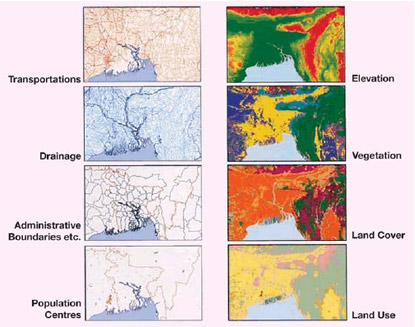
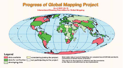
THE United Nations Conference on Environment and in Rio de Janeiro recognized the need to coordinate environmental data and spatial information as an aid to decision making in formulating responses to the challenges of global environmental change and to support sustainable development. The concept of Global Map as a means of doing this was introduced by the Government of Japan and became a formal part of the Agenda 21 action plan. Global Map is a digital map of the world at the scale of 1:1 million which is produced by a cooperative effort of the national mapping organizations of the world. At the time of writing (May 2007) 172 countries and regions were involved in the creation of Global Map. Global Map has eight data layers, four in vector format and four in raster format. These are transportation, boundaries, drainage, population centres (in vector format) and elevation, vegetation, land cover and land use (in raster format). The International Steering Committee for Global Mapping (ISCGM) was established in February 1996 to implement the Global Mapping Project. A secretariat for the Committee was established in the Geographical Survey Institute of Japan and the current Chair of ISCGM is Dr. D. R. Fraser Taylor of Carleton University in Ottawa, Canada. The Committee consists of 18 heads of national mapping organizations with the Scientific Committee on Antarctic Research representing Antarctica and Eurogeographics representing Europe. In addition there are two advisors and 11 representatives of a number of liaison organizations including ICA. The first version of Global Map was released in 2000 using existing global datasets as a basic resource. These included GTOP030 for elevation, GLCC for land cover and VMAP0 for sector data. Common standards and specifications were established and, utilizing the initial global datasets, each nation prepares and verifies its own coverage. At the World Summit on Sustainable Development (WSSD) held in Johannesburg in 2002 Global Mapping was recognized in the political declaration of the Summit and ISCGM was registered as a Type 2 implementation agency for this purpose. Progress of the Global Mapping ProjectIn September 2007, 172 countries and regions were participating in the project corresponding to about 95% of the land surface of the earth. Global Map data for Brazil has just been released. This brings the total number of countries for which Global Map data has been released to 40 countries and 2 regions equivalent to 43.4% of the world’s land surface. Data from a further 81 countries and six regions have been submitted for verification and when these are added coverage exceeds 70% of the earth’s surface making completion of Global Map by the target date of December 2007 attainable although problems exist, such as coverage for states where conflict exists. In addition, a few countries are still not participating in the Global Map project and efforts are being made to engage them. Figure 2 shows the state of progress as of May 2007. Detailed information on Global Map can be found at www.iscgm.org. Global Map as an Operational Global Spatial Data InfrastructureGlobal Map was not initially designed as a spatial data infrastructure but in both organizational and technical terms Global Map meets all of the specifications of a spatial data infrastructure. Global Map is, in essence, an operational Global Spatial Data Infrastructure. Global Map can also be useful in establishing Spatial Data Infrastructures at larger scales such as a region or a nation. Through participation in Global Map national mapping organization can create small-scale framework data for their country but at the same time develop the human and institutional capacity to deal with geo-information. ISCGM has an active capacity building program which includes courses and funding for training both By JICA and GSI. Japan, supplemented by grants of software and training by both ESRI and Intergraph. They also gain experience and knowledge of ISO/TC211 and OGC standards and specification processes as well as some of the legal aspects of copyright, intellectual property and related issues. Members of ISCGM also form a support network with individual members helping other neighbours in developing the Global Map infrastructure. As a result several nations, such as Kenya and Brazil, have used the Global Map infrastructure to develop their national spatial data infrastructure. Global Map is also a useful framework for the development of regional spatial data infrastructures. In Latin America there is an initiative to develop a seamless data framework for the continent based on Global Map. This initiative is led by Chile and involves the Cartography Commission of PCIDEA. A similar effort is being made for the Asia and the Pacific Region through PCGIAP. Euroglobal Map has already been completed and is an important component of the INSPIRE initiative and through CODI and the Mapping Africa for Africans project progress is being made for Africa. |
||||
|
D. R. Fraser Taylor
|
||||||||||||
Challenges for the Future of Global Map and SDIsGlobal Map is an important set of framework data but Global Map coverage needs to be updated on a regular basis. There is also a need to ensure that Global Map standards and specification are updated and become more fully interoperable with emerging standards and specifications being developed by both ISO and OGC. When Global Map was first initiated in the 1990s it used the best standards and specifications available at that time. Since then, however, technological progress has been very rapid and, as a result, Global Map standards and specifications are now being revised to meet the current situation. Interoperability is central to any SDI regardless of the scale of operation at global, regional, national and sub-national levels. It is, perhaps, the major challenge and opportunity for the geo-spatial community. In this respect interoperability between emerging products, such as the KML based Google Earth and the GML/XML based GIS World are of special importance. Another challenge for Global Map is increasing its visible contribution to the central issues for which is was designed – environmental issues and sustainable development. Global Map must move from a supply-driven initiative to much more of a demand-driven initiative. New uses for Global Map, especially in education, are emerging and one important new initiative is the use of the Global Map network for disaster management and mitigation. Global Map also has an important role to play in global observation and is playing a very active role in GEOSS, especially in the area of framework data creation. Global Map is by definition a small-scale initiative and for many problems the scale is too small to effectively address them. This is also true for small nations, especially small island states. Global Map is now accepting data at 1:250,000 for such states which will help to address the problem. A more effective solution, however, is to ensure that Global Map as an operational global spatial data infrastructure is interoperable with larger scale regional national and sub-national SDI initiatives so that maximum use can be made of geospatial information. ConclusionGlobal Map is an important international initiative. Unlike the International Map of the World which failed to meet its objectives Global Map is on track to complete its coverage by the end of 2007 and to create a sustainable long term framework for digital maps of the world at a global scale. |
||||||||||||
|
||||||||||||
|
Pages: 1 2


 (No Ratings Yet)


