|
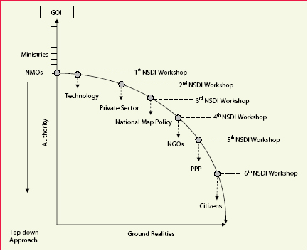
From above figure it is concluded that the overall trajectory of Indian NSDI development has been:
1. Launch of Indian NSDI by national mapping organizations (NMOs) along vertical hierarchy axis (authority) instead of floating it from horizontal axis (ground realities) gave it power of minorities (officials) and not power of the majority (masses). Consequently, it started to decline soon after wards.
2. Initial focus on technology instead of beneficiaries of this technology such as citizens further brought the projectile (Indian NSDI) down to the ground.
3. Non-involvement of private sector thought it was realized strongly in the recommendations of 2nd NSDI workshop added to the inertia faced by Indian NSDI
4. National map policy constraints played its role to pull the projectile down to hit the ground
5. Neglecting role of NGOs hindered to bring local knowledge and community support to the initiative
6. Lack of partnerships such as Public- Private Partnership (PPP) gave monopoly to national mapping organizations (NMOs) which are usually good in making policies but lack in implementation of policies
7. Top down approach instead of bottom up approach to implementation NSDI due to noninvolvement of end users such as citizens caused the Indian NSDI move partially failure if not totally.
Conclusion
The overall trajectory of Indian NSDI development has been, initial focus on technology instead of beneficiaries of this technology such as citizens, noninvolvement of private sector, outdated national map policy, neglecting role of NGOs, lack of partnerships such as PPP and top down approach.
Recommendations
Countries such as Pakistan which are in the processing of initiating NSDI move, should not follow exactly the same trajectory as of Indian NSDI but floating it with the inclusion of all key players of NSDI such as private sector, public sector, NGOs, research and teaching institutions, and media etc.

Reference:
* Georgiadou, P. Y. (2003). Reflections on the Indian NSDI National Spatial Data Infrastructure. Geospatial today : strategic renewal to geospatial world.
* Georgiadou, P. Y. (2006). SDI ontology and implications for research in the developing world : editorial. International journal of spatial data infrastructures research,1, pp.51-64
* Georgiadou, P. Y. and R. Groot (2002). Capacity building for geo – information provision : a public goods perspective. In: GISDECO 2002 proceedings : Governance and the use of GIS in developing countries, ITC, Enschede, 15-18 May 2002. pp. 11-1.11-13.
* Georgiadou, P. Y., S. K. Puri, et al. (2005). Towards a potential research agenda to guide the implementation of spatial data infrastructures : a case study from India. International Journal of Geographical Information Science, 19(10), pp.1113-1130.
* Georgiadou, P. Y., S. K. Puri, et al. (2006). “rainbow metaphor : spatial data infrastructure organization and implementation in India.” In: International studies of management and organization, 35(2006)4, pp. 48-71.
* Georgiadou, P. Y., O. Rodriquez- Pabón, et al. (2006). SDI and e – governance: a quest for appropriate evaluation approaches. URISA journal: journal of the Urban and Regional Information Systems Association.
* Katleen Janssen and Jos Dumortier • (2006). The Legal Framework for a European Spatial Data Infrastructure–Uncrossing the Wires. GSDI-9. GSDI, Santiago, Chile.
* Masser, I. (2005). GIS worlds : creating spatial data infrastructures. Redlands, ESRI.
* National Spatial Data Infrastructure (NSDI) Strategy And Action Plan: Government of India.
* Available at http://www. nnrms.gov.in/nnrms/download/ NSDIStrategyActionPlan.pdf
* Electronic Journals Coordinates (http://www. mycoordinates.org/index.php)
* Online Newspapers • The Hindu ( http://www. hinduonnet.com/)
|


 (No Ratings Yet)


