
Articles in the UAV Category

White-label CAD solution in Japan
Pythagoras BV and Terra Drone have formed a strategic partnership to introduce a customized white-label software solution for the Japanese market. It combines Terra Drone’s SLAM and UAV technologies with Pythagoras’ CAD and point cloud processing software, creating an integrated platform tailored …

A holistic summary of important criteria needed for safe and successful flights
Tito Jun T. Tidula
A former UAV operator/ controller who operated both fixed wing and multirotor drones and is currently a faculty member in the Department of Agricultural and Biosystems Engineering, College of Engineering and Information Technology, University of Southern Mindanao, Kabacan, Cotabato, Philippines
Rezin G. …
SpaceX launches next-generation Italian COSMO-SkyMed satellite
The third satellite part of the COSMOSkyMed Second Generation (CSG) constellation, owned by the Italian Space Agency and the Italian Ministry of Defense, built by Thales Alenia Space, a joint venture between Thales (67%) and Leonardo (33%) and operated in orbit by Telespazio, a joint venture between Leonardo (67%) …
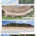
A case study on a beach and rocky cliff
Álvaro Gómez‑Gutiérrez
Instituto Universitario de Investigación Para el Desarrollo Territorial Sostenible, Universidad de Extremadura, Avda. de la Universidad S/N, 10003 Cáceres, Spain
Manuel Sánchez‑Fernández
Instituto Universitario de Investigación Para el Desarrollo Territorial Sostenible, Universidad de Extremadura, Avda. de la Universidad S/N, 10003 Cáceres, Spain
José Juan de Sanjosé‑Blasco
Instituto Universitario de Investigación …
UAVs assist forest officials
ideaForge Technology Limited deployed its Q6V2 UAV to support forest officials in preventing a potential human-elephant conflict in the Silli region of Jharkhand, India. The incident occurred when a herd of elephants strayed from the forest into nearby villages, creating panic among residents. Q6V2 UAV was launhced, …
New remote-sensing system maps Antarctic vegetation
Queensland University of Technology (QUT) researchers have developed an advanced remote sensing method for accurately detecting and mapping Antarctica’s delicate moss and lichen growth, the mainstays of the continent’s fragile ecosystems.
The research team also developed a way to survey Antarctica’s vegetation that is non invasive and will enable accurate surveys …
AIBOT achieves eVTOL milestone at Norton
AIBOT has successfully conducted a f light test at the Unmanned Aircraft Systems (UAS) Center at San Bernardino International Airport (SBD) under the newly established Norton Test Range. The flight was conducted through a partnership with the FAA’s UAS Test …
Latest eBee VISION application software
AgEagle Aerial Systems has introduced version 2.1.0 of its eBee VISION application software, designed to significantly enhance UAV capabilities. The update expands the system’s functionality, introducing circular and grid mapping features. It can continue missions in GNSS-denied environments and allows manual deactivation of GNSS …

In this study, a small-scale customised drone – the so- called Maggy – was developed to simplify and automate the procedures of cleaning explosive devices. Readers may recall that we publsihed the first part of the paper in February issue. We present here the concluding part
Kaya Kuru
School of Engineering and Computing, University of Central Lancashire, …

In this study, a small-scale customised drone – the so- called Maggy – was developed to simplify and automate the procedures of cleaning explosive devices. We present here the first part of the paper. The conculding part of the paper will be publsihed in March issue.
Kaya Kuru
School of Engineering and Computing, University of Central Lancashire, …


 (5.00 out of 5)