Nov 2009
Mycoordinates.org

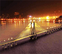
Sea link - a Sea change Shubra Kingdang, S Diwanji Rakesh Kaul, Len Gower | Towards hazards prediction Rainer Mautz, Washington Yotto Ochieng and Hilmar Ingensand   | Sustainable land governance Stig Enemark | Landslide vulnerability  LP Sharma, P Debnath, Nilanchal Patel, MK Ghose

Sea link - a Sea change
Shubra Kingdang, S Diwanji Rakesh Kaul, Len Gower
The marvel that has brought this sea change to the life and landscape of Mumbai is the Bandra-Worli Sea Link – the first ever sea link to be built in India. With India looking to improve and enhance its infrastructure, many projects are being implemented or are in the pipeline around the country. The BWSL will definitely be a benchmark for infrastructure projects in India for many years to come 
[more]

Towards hazards prediction
Rainer Mautz, Washington Yotto Ochieng and Hilmar Ingensand
This article investigates the capability of GNSS aided smart sensor network positioning and RF technology to monitor 3D deformation associated with volcanic activity and other comparable hazardous events
[more]

Landslide vulnerability

LP Sharma, P Debnath, Nilanchal Patel, MK Ghose
The paper studies the various soil characteristics that may increase the landslide in east district of Sikkim in India. This study makes a detail study of the importance of various soil parameters with respect to their influence on slope instability and landslide vulnerability
[more]

Sustainable land governance
Stig Enemark
This paper provides an overall understanding of the concept of land administration systems for dealing with rights, restrictions and responsibilities in future spatially enabled government. We present here the first part of the paper. The remaining part will be published in December'09 edition of this ezine
[more]


Industry news
 
Galileo update
 
Other news

OmniSTAR receiver by Geneq

DataGrid new GNSS receiver

NovAtel Precision Receiver Firmware

u-blox powers ikeGPS™>

Magellan ProFlex 500 and MobileMapper™ 6

Public Safety Interoperability Framework by Intergraph

Ricoh’s picture-based mapping for GIS handhelds

L-3 Interstate new GPS Receivers

ESRI Business Analyst Server

HP expands Large-format portfolio

Blue Marble GeoTranslate beta


First Galileo satellite repositioned
Surrey Satellite Technology (SSTL), UK, has completed the repositioning of the first Galileo test satellite, GIOVE-A [more]

Osmógrafo- The winner of the 2009 European Satellite Navigation Competition
Osmógrafo®, combines satellite positioning with wind measurement and rescue dogs’ sense of smell in order to better determine which areas have already been covered by search teams[more]

Launch of Galileo IOV Satellites delayed
4 Galileo in-orbit validation (IOV) satellites scheduled to launch in 2010 have already missed their first pad date[more]

European Commission reduces Galileo Satellite order
The EC has reduced the number of satellites it expects to order this year for the Galileo program to 22 [more]


GPS IC shipments forecast for 2010

Bahrain joins global tracking system

First U.S. Ground-Based Augmentation System

GPS handsets a threat to PND market

Fleet Management Telematics Device

Now all Mobile Phones location aware

CSR unveils new built-in CPU GPS

Digital village in China

Free access of OS mapping data

ISRO updates

Recovery.gov relaunched

Latlong, launched in Bangalore


© Coordinates, 2009