Volume 20, Issue 3, March 2024 |
|
||||||||||||||||||||||||||||||||||||||||||||||
Volume XX, Issue 2, February 2024 |
|
|||||||||||||||||||||||||||
Furuno Electric Co. has released its dual-band GNSS receiver chip, eRideOPUS 9, which can achieve 50cm position accuracy without correction data.
The product is designed to provide absolute position information and can be used as a reference for lane identification, which is essential for services such as autonomous driving. It also serves as a reference for …
RIEGL has released three airborne survey products. The three systems are designed to enhance sensor performances and capabilities in various segments, from terrestrial, to mobile and airborne applications.
The VQX-2 helicopter pod is designed for airborne data collection. It integrates a RIEGL laser scanner, a high-performance IMU/GNSS unit, and up to five cameras. It also can be easily …

The study provides an overview of contributions made so far on land information management systems, with the sole purpose of ascertaining the progress recorded and inherent challenges to the existing system.
Ifeanyichukwu Valentine Nwafor
Department of Estate Management, University of Nigeria
Raphael Oshiobugie Sado
epartment of Estate Management, Nnamdi Azikiwe University, Awka
Inipami Prince Johnni
Abstract
The need to improve on a …
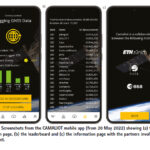
This paper presents results from data collection campaigns using the CAMALIOT mobile app.
Linda See
Novel Data Ecosystems for Sustainability Research Group, International Institute for Applied Systems Analysis (IIASA), Laxenburg, Austria
Benedikt Soja
Institute of Geodesy and Photogrammetry, ETH Zurich, Zurich, Switzerland
Grzegorz Kłopotek
Institute of Geodesy and Photogrammetry, ETH Zurich, Zurich, Switzerland
Tobias Sturn
Novel Data Ecosystems for Sustainability Research Group, International …
India and the US will launch the joint microwave remote sensing satellite for Earth observation, named NASA-ISRO Synthetic Aperture Radar (NISAR) in the first quarter of next year, said Union Minister Dr Jitendra Singh during a meeting with a high-level delegation of NASA led by its Administrator Mr Bill Nelson.
NISAR is targeted for launch onboard …


 |
“Situational and spatial awareness is still very much a human activity”
Air Vice-Marshal Kym Osley |
 |
This comprehensive book charts the course of NSDI journey in India, which is still continuing... |


 (5.00 out of 5) (5.00 out of 5) (5.00 out of 5) (5.00 out of 5)
