|
|
|
|
| |
 |
|
|
Products
602 series of Nikon total stations
Nikon-Trimble Co. introduced the 602 Series of Nikon® Total Stations, new high-precision mechanical total stations that includes both a prism and prismless (reflectorless) model. It also added a reflectorless model to Nikon 502 Series. The new Nikon products are expected to be available soon through Tripod Data Systems (TDS) in the United States and Trimble
internationally. www.nikon-trimble.com
|
|
|
GPS/Galileo OEM receiver platform
Septentrio announces AsteRx1TM, a compact high-end single-frequency GNSS receiver for demanding industrial and professional applications. AsteRx1TM incorporates capabilities for full use of the European Galileo L1 signal. Septentrio receivers have successfully been tracking all signals transmitted since January 2006 by the new navigation satellite, Galileo. It is is a creditcard-sized OEM board with low power consumption and high update rates, offering excellent measurement quality for high-precision positioning even in challenging environments. It is compatible both with the GIOVEA signal and with the operational Galileo signal. www.septentrio.com.
|
|
|
|
Leica GPS900 and MNS1200
Leica Geosystems introduces Leica GPS900, a mid-range RTK GPS system. It consists of a Leica RX900 Controller and a Leica ATX900 GPS Antenna the all-on-the-pole GPS900 RTK rover is ideal for one-person stakeout and topographic tasks. Its reference station offers an easy, convenient and cost-effective solution.
Leica MNS1200 GNSS solution presents a new machine navigation system specifically designed for construction and mining machine operation supporting full GNSS signals (L2C and GLONASS).
Supporting GPS and GLONASS satellites thanks to a new Measurement Engine supporting ultra-precise GNSS signals with 72 channel, this solution optimises working around trees, in canyons, mines and sites with overhead obstructions, and it is also equipped to support future GNSS signals such as Galileo or GPS L5
|
|
|
Autodesk Civil 3D 2007 Extension for Google Earth
Autodesk, Inc. is introducing Autodesk Civil 3D 2007 Extension for Google Earth-Technology Preview. It is designed specifically for civil engineers and surveyors who need to keep all constituents involved in a project, from the planning stages through public approval, apprised of the latest design information.
With a wizard-driven interface, engineers and surveyors can rapidly publish Civil 3D objects and design data in Google Earth. www.autodesk.com/google
|
|
|
Stereoscopic 3D technology
Planar Systems introduced the latest in stereoscopic 3D technology to address imaging applications in geospatial intelligence and photogrammetry.
Planar designed its initial offering with its specific customers in mind due to the demand for a highquality 3D imaging solution and the need to replace discontinued CRTbased systems. Planar’s SD1710 provides a new dimension of digital image quality and user comfort.
www.planar.com/stereomirror
|
|
|
Waterproof Shield for Marine POS Product
Applanix announced availability of a new waterproof exterior casing for its marine-based onboard position and orientation (POS) technologies, POS MV. The new case allows Applanix POS MV inertial measurement units to be set up in exposed areas that may become vulnerable to water submersion or severe exposure to the elements. The cover is compliant with IP68 specifications and is waterproof in depths up to 10 meters. www.applanix.com
|
|
|
LEA-4S ROM-based Module with SuperSense
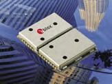
u-blox AG, announced the release of its new LEA-4S GPS module, which combines unrivaled sensitivity, exceptionally low power consumption and a USB port for flexible connectivity in a module measuring just 17 x 22 mm. The software runs from the Read-Only Memory (ROM) in the GPS baseband chip. The software extends positioning coverage to weak signal areas such as indoor car parks. The ANTARIS 4 GPS engine inside provides outstanding navigation performance in the most challenging conditions. www.u-blox.com
|
|
|
Differential Corrections via NTRIP and Direct IP
MobileMapper CE, Thales’ offers differential corrections via NTRIP and direct IP. The new functionality will be available for delivery and via upgrade for current MobileMapper CE owners starting August, 2006 and also offer a free firmware update at the Thales FTP site. With the embedded Microsoft Windows CE .NET operating system, the product users have the flexibility to choose the field software that’s best for them. www.thalesgroup.com/navigation
|
|
|
Intergraph releases Z/I Mission
Intergraph Corporation announced the availability of Z/I Mission, a photo flight management system that provides a solution for aerial survey procedures. It provides a data environment that can access geo-referenced raster backdrop, vector mapping data, and digital orthophotos for flight planning. www.intergraph.com
|
|
|
New version of GeoConcept 6.0
This new version of the GeoConcept GIS is designed to make both map analysis and sharing results, both faster and easier.
The GeoConcept developers in Paris have made major advances in ease of use, enhanced display options, faster analysis and improved control over user access rights.The key advantage of a GIS is the ability to bring together data from disparate sources, using geography as the common theme. GeoConcept@vsnl.com
|
|
|
GeoCalc 6.2 developer tool kit
Blue Marble Geographics announces an update to their GeoCalc 6.2 developer tool kit. This fully objectoriented, cross platform version of Blue Marble’s coordinate conversion libraries was created to meet the accuracy and data conversion needs of GIS and mapping programmers.
www.bluemarblegeo.com
|
|
|
MapInfo Professional version 8.5 launched
MapInfo Corporation has introduced MapInfo Professional version 8.5, the first version of the company’s location intelligence application with Web services connectivity. MapInfo Professional users can now access dynamic data available on the Internet and perform detailed analysis of information in a single environment to make better informed decisions. www.mapinfo.com
|
|
|
Business
Thales Adds GeoSpatial Experts to Business Partner Program
Thales’ navigation announced formation of another partnership in its Business Partner Program, GeoSpatial Experts, which offers GPS-Photo Link software, now fully compatible with the Thales MobileMapper CE handheld GIS data collector. This powerful solution delivers easy and affordable digital photo geo-referencing capabilities for nearly any GIS application including asset management, utilities, forestry, national parks services and many more. www.thalesnavigation.com
|
|
|
Perth builds first infrastructure network
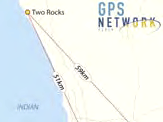
Trimble has announced that it has supplied GNSS reference stations and VRSTM (Virtual Reference Station) software to establish a GNSS infrastructure network in Western Australia. Located in Perth, Western Australia’s capital, the high-precision network is built solely with Trimble® NetR5 reference stations and is the first VRS network with GNSS capabilities. The GNSS network supports both the next-generation GPS L2C and L5 signals and GLONASS signals.
www.trimble.com
|
|
|
GeoEye awarded Airport Mapping Database contract
The National Geospatial-Intelligence Agency (NGA) Stereo Airfield Collection programme has awarded GeoEye a $3.7 million contract to image 365 airfields and produce Airport Mapping Databases (AMDB) over a 12-month period. GeoEye will deliver IKONOS stereo imagery and perform three-dimensional airport feature extraction services in accordance with NGA specifications.
|
|
|
Autodesk to focus more on India, China
Autodesk is increasing its focus on India and China. To concentrate more on these two countries, the company has split the Asia-Pacific region and formed the Asia-Pacific Emerging Geography consisting of India and China, according to Rajiv Nair, Regional Director, India and SAARC region. The company’s expansion in India includes increasing the channel partner network and authorised training centres
www.thehindubusinessline.com
|
|
|
ER Mapper opens office in Singapore
ER Mapper (Australia) has opened a new office in Singapore. The main role of this office is to manage the distribution channels of ER Mapper’s geospatial imagery technologies and solutions in South and South- East Asia. www.ermapper.com
|
|
|
US$2.5m mapping contract for Southeast Asia
Intermap Technologies Corp. has been awarded a US$2.5 million contract for radar mapping in Southeast Asia. Under the agreement, Intermap will collect and deliver geographic 3-D elevation and imagery data utilising IFSAR radar mapping technology. www.intermap.com
|
|


 (No Ratings Yet)


