| SDI | |
Mainstreaming Spatial Data Sharing approach in Sri Lanka
This paper describes the Spatial Data Infrastructure approach being adopted by the Sri Lankan Government to mainstream data sharing |
 |
|
Accessing integrated spatial information for land development and economic initiatives is often ridiculously difficult. Much of a country’s spatial data is managed in closed systems of government. How do business leaders, not-for-profit project teams and policy makers know what information there is, in what format and where to find it?
This paper describes the Spatial Data Infrastructure approach being adopted by the Sri Lankan Government to mainstream data sharing. The approach is multifaceted and challenges decision makers to move beyond policy settings to create a blueprint for sustainable data sharing.
The Underlying Problem
Countries worldwide have significant spatial information holdings collected by various government agencies, but access to data is a common obstacle. The inability to share information across whole -ofgovernment systems is a massive and costly ongoing problem for governments and the international community.
Older technologies are often not interoperable making data integration a problem. The effort to manually integrate updates from one agency to another is labor intensive and time consuming. Data inconsistencies arise and information is liable to become out of date quickly, and the wider community cannot get access.
One of many challenges for policy makers is existing cross-agency data sharing policies that often require paper agreements and contracts. These have evolved over many years and are just not relevant to modern open data initiatives and online cross-government alliances that can be achieved with today’s technology.
A recent study of data sharing in Sri Lanka has revealed that using a Spatial Data Infrastructure (SDI) approach has potential to deliver economic, social and environmental benefits to the wider community and financial benefits to government.
The data sharing problem is not unique to Sri Lanka. Many countries face problems associated with accessing and using their spatial information assets. The mechanisms by which agencies typically share information is via customized exchanges of bulk data. The approach is cumbersome, resource intensive and data is prone to becoming out-ofdate because information is replicated and updates are not sustainable.
A common problem is the lack of clear oversight of national/internationally funded projects that acquire spatial information. This leads to operational inefficiencies, as limited awareness of newly acquired project datasets results in organisations recollecting the same information at a later date. A more practical solution is required.
The Game Changer
Having an operational SDI in place is a game changer. It means that business leaders, not-for-profit project teams and policy makers will have the ability to work at scale using the best available data that is easily accessed. It also means that valuable project data can be seamlessly scaled up in the national interest by incorporating it within a country’s SDI. In this way, projectlevel flood models can be incorporated into nationwide models and reused by the insurance sector to make decisions about levels of risk. Similarly, imagery of the built environment can be reused by the real-estate sector and developers to attract international investment.
A disaster management project in Sri Lanka recognized early that information from a variety of sources was required, but access was problematic. Instead of recreating new datasets and systems, which would have added to supply chain complexity and duplication, the project sought to resolve the underlying data sharing problem as a way to move forward for the project, government and for society as a whole.
Data reuse is a central SDI principal. All spatial data investments are done in a way that accrues benefits nationally and globally – well beyond a project’s lifetime. This includes scaling-up project-level spatial data acquisitions to ensure that valuable project data is transitioned to a country’s SDI for reuse.
Policy support, leadership, established partnerships and financial considerations all relate to the feasibility of going to scale. Without these broader inputs, projects will assuredly result in isolated spatial investments that have one-off usage with benefits only accruing to project participants in the short term.
Rationale for Change
The data sharing problem requires urgent attention. While spatial data has significant value as a single information product; it is the integration of spatial data with other information that increases its value exponentially to government and businesses.
Continuing with the traditional approach is not an option. Government agencies will struggle to deliver services that meet consumer and industry expectations in the future. The new norm is to find contemporary ways to increase the effectiveness and efficiency of government services, increase productivity and contribute to innovation excellence across the public and private sectors, and broader community.
There are considerable economic, social and environmental benefits that can be achieved from investments in spatially referenced information (ACIL Tasman, 2008, LGA, 2010; MNR, 2015; EC, 2006). In Sri Lanka, the population is expected to grow at an annual rate of around 0.86%, from its current population of 21 million. Industrial activities have been increasing, and many agricultural workers are expected to seek higher-paid employment in industry and the services over the coming years. Many of these jobs will be in urban areas and this suggests an accelerating rural–urban transition. Achieving employment growth, while ameliorating potential adverse social and environmental impacts from urbanization will be a key development challenge for Sri Lanka (MENR, 2014), and continued growth will increase demand for spatial information for both planning and operational decision-making.
Governments are continually looking for ways to reduce future capital expenditure and Sri Lanka is no different (ICTA, 2014). A shared approach to the delivery and management of spatially-related information is one way to achieve this. When agencies implement their own spatial infrastructures, to give access to their spatial data holdings, the total cost to government is much higher than if a shared infrastructure approach is adopted. With a National approach, there is an opportunity for the smaller agencies to leverage off the investments by larger agencies for minimal incremental cost, with economies of scale yielding further reduction in per-unit costs.
The Sri Lankan Approach
The multifaceted SDI approach conjures up a highly complex system for the storage and use of data that can be daunting – especially for developing countries. This is not the case. The Sri Lanka experience shows that a SDI can be implemented in manageable stages and piloted for specific applications. There are six components planned for the Sri Lanka Spatial Data Infrastructure:
• A Governance Model that brings agencies together to share spatial information, reform cross-agency business processes, acquire data strategically and adopt modern information technology standards.
• A Legal and Policy Framework that provides clear direction and unified approach to data sharing including guidelines for custodianship, data acquisition, spatial data management and access, privacy, security of sensitive data and intellectual property management.
• A Map Portal to deliver spatial information centrally in an online and mobile environment.
• A Data Framework that provides for the orderly management of data and metadata.
• Spatial Data Supply Chains, which minimize manual data handling, and provide for authoritative data sources as well as local community knowledge through crowdsourcing initiatives.
• A Modularized System designed to grow capability over time.
When implemented together, these components effectively institutionalize cross-government data exchange, operational transparency, digital service delivery and importantly, the ability to mainstream spatial data sharing.
The Strategic Enabler
The Sri Lankan Government has recognized for some time that current data sharing processes could be more efficient (UN-SPIDER, 2011), and the rationale for change is encapsulated in the consultation draft of the government’s SDI strategy; Powering Decision Making and Innovation Using Spatial Information Technologies (Sri Lankan Government, 2014). This strategy seeks to address environmental and social imperatives and stimulate the economy.
The Sri Lankan SDI will be a strategic enabler for the many government initiatives aimed at planning for economic growth, delivery of better services, poverty alleviation, socially inclusive development, tourism growth, protection of the environment, disaster management, regional cooperation and, importantly, transparency in governance (Sri Lankan Government, 2014).
A government program to improve the supply of clean water and sanitation in rural areas requires integrated spatial techniques from which planning and development decisions can be made. Currently, information is fragmented across a number of departments. With improved access to information, agencies can focus on their core tasks rather than diverting resources into searching for, and retrieving, data from other agencies.
Spatial information can be applied to improve agricultural productivity. In Sri Lanka, small-scale farms have declined over the past decades due to irregular rainfall, recurrent drought and poor irrigation. Food security (in terms of availability, accessibility and affordability) is uncertain, notably in the rural regions (MENR, 2014). Integrated spatial information can assist small-scale farm holders to achieve higher productivity through yield monitoring, crop stress mapping and soil condition monitoring.
Promoting Sustainable SDI Governance
Without an SDI in place, governments typically lack the inter-organizational communication necessary to coordinate and provide integrated access to their spatial data holdings. This is also the case in Sri Lanka. Cross-agency interaction and collaboration is often based on official channels of information flows (UN-SPIDER, 2011). This approach it subject to a high degree of bureaucracy for data requests, the preparation and signing of data sharing agreements, and manual data transfer methods. Delays are frequent and the process is costly. While fast-tracking is possible in the event of emergencies, the process is often reliant on personal relationships, which can collapse when changes in staffing occur.
A new approach to spatial data governance is required: one that will ensure data is readily accessible so that it can be leveraged in the national interest. The governance model considered for Sri Lanka embraces this approach. The principles are:
• an approach that focuses on strategic national imperatives, as well as, institutional requirements;
• a governance model that is easily accessible and credible to participating institutions;
• a model that is driven from the top, so that participating institutions are well supported and guided in their daily tasks and decisions where the SDI mandate is concerned;
• an alertness to inter-agency costshifting where SDI programs and projects complement changing cross-government strategies; and
• regular cross-sector and crosscommittee SDI reporting and monitoring, complemented by reevaluation of performance expectations and adjustments where necessary.
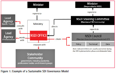
A key characteristic of a sustainable SDI Governance Model is the central governing body often referred to as the National SDI Office (NSDI) (Figure 1). This office coordinates cross-sector SDI activities, formulates strategies and produces general standards, policies and guidelines for data management and access. Its core mission is to provide stewardship and build networks of people to continually improve the sharing of spatial information and promote its broader use. For this reason, the NSDI office is usually an independent body representing whole-ofgovernment needs and not just the needs of a single Ministry or Department.
SDI Governance Models need to make provision for project data and its ongoing maintenance and reuse. All projects that acquire spatial information should make their planned acquisitions known to the NSDI Office for oversight and so that project leaders can be directed to appropriate data custodians for responsibility of its residual value. Without a SDI Governance Model in place, there is often no provision for the ongoing storage and management of project data and these assets quickly depreciate in value.
Globally, there is a shift to more inclusive models for SDI governance. In Sri Lanka, the considerable breadth of stakeholder groups calls for an enduring underpinning structure that takes into account the balance between public and private sectors, and data providers and users. Notably, the private sector and academia will have a significant role to play. User demands will often trigger partnerships and alliances to produce and share information.
Cooperation is assisted through a Steering Committee (appropriately mandated) that sets policy and binds institutions to work towards achieving common interests. Operational SDI matters are best dealt with by a body of experts (or NSDI Council) drawn from the line Departments.
The Policy Framework
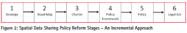
An all too familiar difficulty for governments is that legislation and policy solutions frequently fail in their first evolution due to lack of support. The lesson learned is to deliver policy reform incrementally, where each stage is geared towards inspiring cooperation and collaboration for data sharing. Involvement of a broad range of stakeholder groups early and at every stage promotes support for open data initiatives.
The six stages are (Figure 2):
1. A strategy that encapsulates the vision and goals of the broader stakeholder group for the use of spatial technologies in delivering on the important social, economic and environmental objectives of government. This builds support for open data initiatives across the broader stakeholder group.
2. A Road Map that identifies the critical steps towards achieving the short and long-term SDI outcomes including anticipated milestones to manage stakeholder expectations.
3. An Intergovernmental Charter for Spatial Data Management that articulates the main principles and some specific undertakings required by data custodians. The charter is generally a 1-2 page Memorandum of Understanding (MOU) enacted at the Steering Committee and NSDI Council levels. Its purpose is to instigate and build cooperation between agencies to develop and implement data sharing policies in the national interest.
4. A Policy Framework that describes the overall strategic approach and desired future. The objective is to set out what needs to be achieved in order to bring about change. It is often an ‘umbrella’ strategy to which a number of policies relate.
5. The actual policy/s drafted in consultation with stakeholders. The policy/s identifies how to achieve a particular strategic outcome. It clarifies what needs to be done and by whom. It is likely to include a policy position followed by a set of practice standards or detailed procedures supported by guidelines or toolkit. Seven policies that collectively contribute to effective and efficient management of spatial data throughout its lifecycle are: custodianship, data acquisition, spatial data management, information privacy, sensitive information, data access and pricing, and intellectual property management.
6. Legislation is the final step in policy reform and may not be required if the policy/s is proving an adequate instrument for opening up access to data. Also, countries often have existing legislation for intellectual property rights management, information privacy, copyright and data security, which already provide an adequate basis for spatial data access and management.
Guidelines for Scalingup Project-level Spatial Data Acquisitions
Having a SDI Policy Framework in place means that all new projects have the necessary information to plan, record and capture spatial information in a way it can be reused. This includes the Spatial Data Acquisition Policy that has the following principles for working at scale:
• Avoid Duplication: All projects and activities that give rise to substantial datasets will establish at the outset whether suitable data already exist in a potentially usable form, or whether new data needs to be acquired.
• Assign Custodianship: Prior to approval of new data collection activities, establish how the acquired data will be exploited for maximum benefit, identify who will be responsible for full exploitation of the data, and how the benefits will be shared.
• Plan Ahead: Data handling and storage needs are planned in order to manage and maintain databases in a way that maximises data investments and benefits, and meets business priorities.
• Consult: Consultation is carried out with relevant authorities to determine the correct protocols, methodologies and classification procedures to use for newly acquired data.
• Determine Point of Truth: When sourcing data, work with relevant agencies to determine the authoritative ‘point-of-truth’ dataset.
• Compliance: Custodians to provide external contractors (project teams) with compliance standards for the acquisition of data including, but not limited to, procedural guidelines, data standards and metadata standards to facilitate data reuse.
• Assess Fit for Purpose: All new datasets are assessed for their appropriateness against specified criteria including, scale, resolution, accuracy, reliability, classification and integrity.
Working at Scale Using the Map Portal
The Map Portal is one of the key enablers to working at scale. Projects have ready access to datasets via a data catalogue. Access to data stores can be achieved via a decentralised or centralized warehouse.
When compared to the governance model and data sharing polices, the technology installation side of the SDI can often be achieved far more smoothly because:
• there are a number of systems available in the market that are readily deployable; and
• resistance to collaboration is lessened as the actual data remains within the control of custodial agencies. This alleviates concerns with information security, as security can be managed within the control of each organisation even though access to data is opened up.
Getting Organized with the Data Framework
Major technical obstacles for governments are often the lack of standards for spatial data, incompatible classification schemes, and no common vocabulary and/or data dictionary.
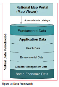
A three tier Data Framework is being considered for Sri Lanka (Figure 3). This model supports projects working at scale, as well as the ability to scale up project data acquisitions. The tiers include:
• Fundamental data themes for which users (including projects) have a recurring need i.e. administrative boundaries, reserves, place names, transportation, buildings, hydrography, utilities, elevation, land use, cadastre, address and imagery.
• Application data themes that often include project data, such as flora and fauna for ecological and biodiversity studies, hazard risk maps for disaster preparedness and disease outbreaks for public health programs.
• Socio-economic data themes such as census statistics or household surveys conducted through projects. For Sri Lanka, as with other countries embarking on their SDI journey, organizing the catalogue requires a data inventory to understand the breadth of data assets and where they are held. During the inventory process the level of data access is determined. Categories of access levels include public access, governmentonly access and restricted content.
Mainstreaming Spatial Data Supply Chains
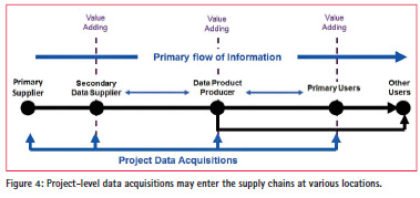
A challenge for project teams is often how to move project-level data acquisitions, including community provided information, into mainstream spatial data supply chains. Because different data vocabularies, standards and schemas can occur, exchanging and reusing projectlevel data is not necessarily straightforward and project data may enter the supply chain a various locations (Figure 4).
Given technology interoperability today, this situation is hard to comprehend. The problem is historical. Since the 1980s-90s, when digital mapping systems first came into effect, organisations in many countries typically handled everything from data collection, presentation, marketing and distribution and often adopted their own information technology and data standards. Many of these datasets are still managed and maintained separately today; creating ambiguity for end users and an unnecessary financial overhead for governments.
While this is the case for crossgovernment supply chains in Sri Lanka, the vertical government supply chains are streamlined with consistent data models and standards particular to each institution. This puts Sri Lanka in an extremely advantageous position, as vertical supply chains (i.e. between the various levels of government) are typically far more difficult to control with reliability, particularly in countries where provinces/states have a long history of autonomy, as is the case in Australia, United States of America and Vietnam.
With a plethora of data models and standards in place, provincial/state systems cannot be easily joined with consistency. On-the-fly processes to federate province/state datasets to create a seamless nationwide view are currently being investigated (CRCSI, 2013). In the interim data harmonization is the customary approach.
The implementation of a SDI is an opportune time for governments to evaluate their spatial data holdings and supply chain strategies and bring clarity to data custodianship and responsibility for specific upstream and downstream activities. It is also time for project sponsors to consider operating within a more sustainable supply chain framework rather than within an isolated project scope. Methods available to project teams include:
• Incremental Updating, where project data updates are forwarded to the data custodian for the inclusion/integration into the authoritative database.
• Database Versioning, where updates are performed by the project team on a copy of the custodian’s database, which is then integrated into the authoritative source by the custodian.
• Direct Editing, where updates are performed directly to a custodian’s authoritative database.
Research is currently examining more automated methods to conflate project-level data with authoritative sources (Yu et al, 2016).
Preparing for the Future with a Modularized System
SDIs characteristically incorporate design flexibility and therefore, any number of applications/modules can be built from accessible data stores. This is an important capability given the changing SDI landscape.
Digital economies are expanding worldwide and 40 percent of the world’s populations have access to the internet, and the number keeps growing (Internet Live Stats, 2016). With internet users spending more than 108 minutes per day on mobile internet services (Statistica, 2015), spatial information has the potential to become further embeddedspent an average of 74.4 minutes on mobile internet services per day. As of the second quarter 2014, this time had increased to 108.6 minutes per day. 74.4 minutes on mobile internet services per day. 74.4 minutes on mobile internet services per day. 74.4 minutes on mobile internet services per day. 74.4 minutes on mobile internet services per day.spatils in digital economies.
The enabler for this change will stem from the Internet of Things (IoT), with city-wide sensors connecting people with locations and services, becoming part of information systems and enduser applications. For government this means an unprecedented opportunity to streamline city operations, improve logistical management, reduce service costs and advance overall economic sustainability.
This is where the full value of the SDI comes into being. Technologies for climate sensors, animal tracking, silo stock calibrations, flood gauges, pest monitoring and dust cloud detection systems all have spatial location as a crucial component and can be incorporated into the SDI as accessible datasets from where they can be reused again and again for Smarter City services.
Conclusion
While SDI solutions come with some significant challenges, getting the policy and governance components in place early will allow governments to achieve major incremental steps towards achieving a robust data sharing solution; one in which business leaders, not-for-profit project teams and policy makers can work at scale using the best available data, and where project-level data can be scaled up and reused in the national interest well beyond a project’s lifetime. This is the plan for the Sri Lanka SDI.
Acknowledgements
This paper would not have been possible without the support of the National Spatial Data Infrastructure Committee, Government of Sri Lanka and Dr I.H.K Mahanama, Secretary Ministry of Lands.
This paper is an abridged version of the original prepared for presentation at the “2016 World Bank Conference on Land and Poverty” The World Bank – Washington DC, March 14-18, 2016.
References
ACIL Tasman (2008) The Value of Spatial Information: The impact of modern spatial information technologies on the Australian economy, [Online] Available at http://www.crcsi.com.au/Resources/ general-interest, accessed Oct 2013.
Cooperative Research Centre for Spatial Information (CRCSI) (2013) Spatial Infrastructures Research Strategy, [Online] Available at http://www.crcsi.com.au/ library/resource/spatial-infrastructuresresearch- strategy, accessed June 2015.
ICTA (2014) Transforming a Nation through Information Technology, [Online] Available at http://www.icta.lk/en/esri- lanka.html, accessed June 2014.
Internet Live Stats (2016) Internet Users in the World, [Online] Available at http://www.internetlivestats.com/ internet-users/, access December 2015. Local Government Association (LGA) (2010) The Value of Geospatial Information to Local Public Service Delivery in England and Wales, Final Report, [Online] Accessible at http:// www.acilallen.com.au/cms_files/ ACIL_Geospatial_UK.pdf
Ministry of Environment (2009) National Action Plan for Harita Lanka Programme [Online] Available at http://www.environmentmin.gov. lk/web/pdf/Harita_Lanka_Book_ small.pdf, accessed June 2014 Ministry of Environment and Natural Resources (MENR) (2014) National Sustainable Development Strategy, under development, [Online] Available at http://www.un.org/esa/ agenda21/natlinfo/countr/slanka/ nsds.pdf, draft accessed June 2014.
Ministry of Natural Resources Canada (MNR) (2015) Canadian Geomatics Environmental Scan and Value Study, [Online] Available at http://ftp2.cits.rncan.gc.ca/pub/geott/ ess_pubs/296/296426/cgdi_ip_41e. pdf, accessed December 2015.
Sri Lankan Government (2014) Powering Decision Making and Innovation Using Spatial Information technologies, Consultation Draft [Online], Available at http:// www.landmin.gov.lk/web/upload/ downloads/SLSDI%20Strategy. pdf, pp35, accessed Nov 2015
Statistica (2015) Mobile Phone Internet User Penetration Worldwide from 2014 to 2019, [Online] Available at http:// www.statista.com/statistics/284202/ mobile-phone-internet-user-penetrationworldwide/, accessed December 2015.
UN-SPIDER (2011) Technical Advisory Mission, unpublished works, 17-21 October.
Yu. F, West. G, Arnold. L, McMeekin, D. Moncrieff, S (2016) Automatic Geospatial Data Conflation Using Semantic Web Technologies, in proceeding of 39th Australasian Computer Science Conference, 2016.


 (2 votes, average: 2.50 out of 5)


Leave your response!