| Application - New, Disaster Management | |
International lessons for land administration in Nepal?
This paper involves a review of disaster recovery and land administration following earthquakes in Haiti and New Zealand in order to identify lessons for Nepal |
 |
|
 |
|
A major disaster puts any land administration system at risk of failure at the time it is most needed. This paper addresses the lessons that Nepal may learn from 2 quite different countries affected by earthquakes in 2010 – Haiti and New Zealand.
Following this analysis, some lessons for land administration in Nepal are provided as well as questions that Nepal agencies and land professionals should consider to devise the best approach to recovering from this disaster and rebuilding their country.
Why look at Haiti & New Zealand?
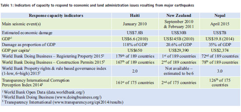
Apart from the fact that they both suffered a major earthquake in 2010, why is it useful to look at Haiti and New Zealand? Haiti and New Zealand are close to the extremes for land administration systems that are recovering from recent major earthquakes, with Nepal somewhere in between. This is evident from Table 1 which provides some economic and governance indicators illustrating the differences in capacity of these 2 countries to manage the challenges resulting from major disasters. Identifying common themes from Haiti and New Zealand provides an opportunity for lessons that are likely to be relevant for Nepal.
It is evident that New Zealand is in a much stronger position to respond to the disaster than Haiti. And yet in New Zealand, the land administration systems were put under considerable and unusual pressure. It is therefore reasonable to say that all countries will struggle to cope for many years following a major earthquake.
Lessons from Haiti
The land administration system before the earthquake
Giampaoli & Freudenberger (2010) and Levine et al (2012) outline the land tenure issues that existed in Haiti at the time of the 2010 earthquake. They note the complexity of the land tenure arrangements and in particular the informal tenancy agreements known as affermage. These agreements initially developed in rural areas where rural landowners tolerated a tenant building a house which the tenant owns while not owning the land. This practice then became widespread including in urban areas.
There were grants of state land by Presidential decree of doubtful legality, illegal occupation, unpaid tenancy and squatting. Legal doubts apply to inheritance and the limitation periods for acquiring rights through adverse occupation. Informal agreements developed, in part due to low levels of trust in the government institutions responsible for land administration.
As a result, only 40% of landowners had any documentation of rights. It was almost impossible to know definitively who owned what and this extended to the government which also does not know exactly what it owns.
Neither land tenure nor land use planning had a single “home” within government. An attempt to create a central land register had only been trialled in one province and parts of Port au Prince.
Post-earthquake challenges for land administration
These existing problems were made much worse by the earthquake that hit Haiti on 12 January 2010 (Giampaoli & Freudenberger, 2010; Levine et al, 2012). The land agency was decimated with significant loss of land records, staff and damage to buildings and infrastructure.
The Haiti government was unable to provide a lead on land issues and the aid agencies did not adequately understand the complex informal tenure arrangements that were such an important part of the existing system for most Haitians. Aid agencies were unable to adapt to existing systems or coordinate responses where land tenure was a critical factor in the response such as locating “temporary” camps. They sought proof of land ownership before erecting new temporary structures or providing assistance for repair of damaged dwellings. Proof of land ownership was difficult even before the earthquake and worse after the earthquake.
As is usually the case following a disaster, vulnerable groups were most adversely affected initially and remained at risk the longest. Two and a half years after the earthquake, nearly 400,000 people remained in transitional settlement camps without access to basic infrastructure. These camps are becoming permanent. Initially half the camp population was on state land, with half on private land and there were efforts to reclaim private land by evicting camp occupants.
Restitution for private land occupied by camps or required for recovery efforts was severely hampered by the difficulty of proving rights to land – and thus compensation.
Some reconstruction projects have been halted by disputes over who owned the land. The institutional connection between humanitarian action and town planning was highly fragmented and ineffective. As a result, funding was poorly used or wasted and opportunities to “build back better” were missed.
There are indications (Levine et al, 2012) that assistance for rebuilding houses would have cost much less than the cost of prefabricated temporary structures that led to long term settlement in camps. Thus the aid funding was not directed towards helping as many people as possible.
Lessons from New Zealand
On 4 September 2010, an earthquake in the Canterbury plains near the city of Christchurch caused widespread damage to property in the region and particularly in the city. Surprisingly there was no loss of life – mainly because the earthquake occurred in the early hours of the morning when damaged offices and shops were empty.
On 22 February 2011, an aftershock of lower magnitude but greater severity (peak accelerations more than double that of gravity) was located under the city of Christchurch and caused enormous damage including the collapse of many buildings. The number of deaths was relatively low at 185 – in part because many buildings that collapsed were still unoccupied as a result of damage from the September 2010 event.
With both events, a key aspect of the response was rapid and strong leadership from Government. This was evidenced by legislation – the Canterbury Earthquake Response & Recovery Act 2010 came into force only 10 days after the first earthquake and provided broad and unprecedented emergency powers. This included setting aside many other Acts to the extent that they may hamper or delay response and recovery.
This was extended by the Canterbury Earthquake Recovery Act 2011 passed not long after the February 2011 aftershock. This included specific surveying & title provisions to avoid delays in rebuild including fast-track safeguards to protect property rights and protection of surveyors and public servants from liability while acting in good faith. It also included powers to demolish unsafe buildings, erect temporary buildings, undertake works, and to take land – with full compensation – to support recovery, rebuild and public safety.
Following the earthquakes, it was clear that the world class land administration system was struggling in Canterbury. This system is overseen by 3 statutory regulators, the Surveyor-General, Registrar-General of Lands and Valuer- General. They set standards and monitor compliance by land professionals and government agencies. These three statutory regulators worked with government to make necessary changes (standards, processes and advice on legislation) while retaining important protections.
Changes to boundaries from seismic land movement – fault rupture
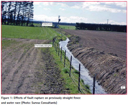
The fault rupture for the September 2010 earthquake reached the land surface resulting in lateral movement of up to 4 metres. Straight-line boundaries across the fault trace were split, other boundaries nearby were bent or distorted.
In the absence of any statutory or common law applying to this situation, the Surveyor-General was empowered to decide that such boundaries would move with the bedrock. This is consistent with slow non-seismic tectonic plate movement. It preserves ownership of the land and the assets located upon the land.
Changes to boundaries from seismic land movement – soil liquefaction
A more complex situation prevailed in Christchurch City. While also subjected to some movement of the bedrock, greater movement resulted from liquefaction of soils, which caused fences, houses and survey marks to move inconsistently by decimetres up to metres.
The practical application of common law on boundary definition is difficult and unclear in this situation. Given the ambiguous movement of survey evidence, accepted survey practices lead to uncertain or inconsistent results (O’Brien, 2015). Therefore a bill is before Parliament at the time of writing – the Canterbury Property Boundaries and Related Matters Bill – to allow the Surveyor-General to provide legal clarity and confidence.
Protecting Survey Infrastructure
The earthquakes moved or damaged survey marks across the entire region. The importantce of the survey infrastructure to recovery and rebuild was recognised soon after the first earthquake. This included the need to reinstate vertical control for repair of roads, sewers and stormwater.
Additional funding was provided by government for rapid re-survey of the control network by GPS and precise levelling. These surveys also provided good scientific information and allowed extent of boundary issues to be determined. However successive resurveys were subsequently required after major aftershocks that caused further movement of survey control marks. A secondary risk to the survey networks was the land clearance and rebuild plans, which threatened all survey & boundary marks in the central city. Contracts were let to locate all survey marks in the central city by GPS to preserve survey evidence without delaying the rebuild.
For a cadastre based on mapping such as in Nepal, before & after high resolution satellite imagery would achieve the same purpose.
Protecting Survey & Title Records
Lessons on the importance of protecting of survey & title records can be drawn from an earlier earthquake in New Zealand – the 1931 Hawke’s Bay earthquake. The main shock was followed by fires in the city which burned for 72 hours. Almost all paper titles and survey plans in the region were destroyed. This caused severe disruption to the land administration system for many decades and missing records can still be a problem today.
Subsequently all survey plans throughout New Zealand were microfilmed with copies (disaster sets) held in different cities. Later these were converted to digital images along with images of all title records. The lessons from 1931 meant that there was no loss of information resulting from the 2010 and 2011 earthquakes. Survey & title transaction processing was able to continue after the earthquakes even though the land agency office was unable to be occupied for several weeks and though original paper records had been archived in a building that was unsafe to enter.
Residential Land Acquisition
Based on a geotechnical assessment of land damage – particularly the likelihood of soil liquefaction in future earthquakes –approximately 8000 private residential sections were deemed unsuitable for housing. These were acquired by the government with compensation for landowners set at the 2009 valuations. This was generally accepted as being fair because 2009 was a recent peak in the New Zealand property market. However suitable houses available for resettlement became scarce and therefore more expensive. Therefore the compensation values, while generally fair, were often not sufficient for replacement.
There was effectively no centralised re-settlement process. Compensated landowners resettled themselves in private sector new developments on stable land on the outskirts of the city. This unusual situation was made possible by the high proportion of properties insured under a government scheme created after 1931 Hawkes Bay earthquake. This resettlement model offered maximum private choice which suited New Zealanders, but might not work in many countries.
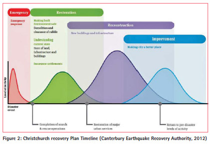
Planning to Build Back Better
“Build back better” is a commonly used expression after a major event. This goal should be part of the early planning but Improvement is not achieved until the end of the plan. The more urgent needs are Emergency, Restoration of Basic Needs and Reconstruction. This is shown in the Christchurch Recovery Plan (Canterbury Earthquake Recovery Authority, 2012).
Common Challenges for Land Administration in a Post-Earthquake Context
Based on analysis of Haiti and Canterbury, New Zealand, the following challenges can be identified for other countries, like Nepal, responding to major destructive earthquakes.
Physical Damage
• Damaged survey marks (geodetic, survey, boundary).
• Damage or loss of land records.
• Residential land or farmland is no longer habitable or arable.
• Boundary disputes result from loss of buildings and survey marks as boundary evidence.
• Movement and distortion of property boundaries due to liquefaction or fault rupture.
Adjudication
• Difficulty resolving legitimate rights to land.
• Eviction and land grabbing.
• Lack of data on pre-disaster boundaries or building footprints.
• Lack of recognition of legitimate predisaster informal rights to land.
• Informal right holders such as tenants lose access to land or housing and are denied finance and compensation.
• Government acquisition of land may not recognise or compensate all legitimate land rights.
• Government compensation may be based on inadequate valuations. Capacity of land agencies
• Loss of personnel (death, injury or staff moving away from seismic risk) may severely reduce expertise available to land agencies.
• Damage to government buildings and infrastructure may prevent ongoing processing of land transactions.
Pressure on land agencies
• Increased demand for land agency services is likely post-disaster – at a time when capacity has been reduced.
• There will be additional pressure from government to respond quickly.
• Responsibility for land administration may be spread across more than one Ministry.
• Loss of agency capacity also reduces the ability to coordinate responses.
Less clarity of the role of land agency officials
• In normal times, officials are expected to apply land transactions rules and standards carefully and cautiously to protect rights in land. However in the aftermath of a disaster, bureaucratic caution may be discouraged by public or political leaders.
• Staff may be unclear whether the old rules and standards are still sensible or applicable.
• Short-term expediency to assist recovery and rebuild efforts may have long term negative implications for land tenure and administration.
Conclusions
Some lessons for land administration in Nepal from the experiences in Haiti and New Zealand include:
• Leadership comes from the government – solutions often come from the people (they know what they need) and from land professionals (they know what will work).
• It is important to engage with ALL stakeholders and interests in land.
• Target the vulnerable through awareness-raising of people’s rights to land and education on the processes of land administration.
• The land agency is central and capacity building will be needed. A multi-stakeholder, multisector response is needed.
• Sound adjudication principles are still required – decisions must be transparent equitable and enduring.
• Build Back Better is a long term plan – immediate needs may need temporary solutions that can evolve to longer term improvement.
From these lessons, some questions for people involved in post-disaster land administration in Nepal to consider might include:
• What are biggest risks to the land administration system?
– How are those risks best managed with limited resources?
• What is needed now? What will be needed later?
• What is “Fit-For-Purpose” in Nepal? Specifically, clarity is required on what immediate and longer term purposes or outcomes are to be achieved.
– The model for Fit For Purpose Land Administration proposes adaptive process of staged improvements that are most “fit” (sufficiently effective) for meeting the defined purposes.
• Are the survey infrastructure and the documentation of boundaries and rights at immediate risk of further loss or severe damage?
– How can they be protected?
• Are valuations sufficient for land acquisition compensation?
• How will the transition back to a better “normality” be managed?
• What use can be made of a range of international land administration tools?
– Fit for Purpose Land Administration
– Gender Evaluation.
– Pro-Poor Land Recordation.
– Social Tenure Domain Model and Land Administration Domain Model.
– International Guidelines on Urban and Territorial Planning
References
Canterbury Earthquake Recovery Authority, (2012) Christchurch Central Recovery Plan. Retrieved from https://ccdu.govt.nz/the-plan
O’Brien, C., (2015) Regulatory impact statement: Canterbury property boundaries policy decisions. Retrieved from: http://www.linz.govt.nz/land/ surveying/canterbury-earthquakes/ faqs-for-canterbury-property-owners
Giampaoli, P., Freudenberger, M. (2010) Land Tenure and property rights in Haiti. USAid, Retrieved from: http://www.usaidlandtenure. net/sites/default/files/USAID_Land_ Tenure_Haiti_Issue_Brief_0.pdf
Levine, S., Bailey, S., Boyer, B., & Mehu, C. (2012) Avoiding reality: land, institutions and humanitarian action in post-earthquake Haiti. Humanitarian Policy Group. Retrieved from: http:// www.odi.org/publications/6979- haiti-land-earthquake-humanitariancluster- camp-shelter


 (66 votes, average: 1.02 out of 5)


Leave your response!