Articles in the LBS Category

As traffic jam is getting a bad reality in our times, realistic information on the traffic situation together with optimized routing to reduce overall waiting time on the trip become more and more valuable all over the world. But how to vlaidate, if the information provided is reliable and trutsworthy? On the first look, this sounds easy, but as truth is in the details, a lot of hurdles have to be passed for a successful finish.

Today, mobile devices are not only tools for the communications but also personal assistants. People could use the mobile device built-in Global Positioning System (GPS) receiver to search for information based on his/her location, thus called Location Based Service (LBS). However, due to the GPS signal propagation limit, the positioning and navigation services are discontinued when the user enters the indoor environments. When users are in the indoor environments, how to continuously obtain their locations becomes a popular research topic.

Gianluca Falco, Fabrizio Dominici, Gianluca Marucco, Antonio Defina
The integration of navigation and communication functionalities is one of the key elements exploited in new location-based systems and services
GNSS technologies are progressively becoming one of the key elements in most of innovative wireless applications. Most location-based services and systems are in fact …

Niki Regina, Matteo Zanzi
In this paper three different solutions are proposed for the problem of location-based selective broadcasting of traffic messages
Although at present its implementation within the full operational capability is under discussion and called into doubt due to recent changed circumstances in the overall system management, one of the initially planned features of GALILEO …

The Netherlands are a small country in the North West part of Europe with a high density of population. The area of only 41.000 km² is used by 16 Mio. Inhabitants, resulting into 400 inhabitants per km². There is an excellent infrastructure with 2.300 km of motorways and 137.000 km of roads in total complemented by a network of railways and bicycle tracks. The roads are used by 8 Mio. cars and 140.000 heavy goods vehicles. Although…

Transport of people and goods is one of the pilars of civilisation. The
exchange of goods, services and ideas is in foundation of modern economy, as well as it was in the past. However, growing population generates new challenges for traffic control that leaves no space for classic solution but calls for the innovative and multidsciplinary approach based on the latest scientific and technology achievements…

The patented TIDGET® (“tracking widget”) sensor operates by taking brief snapshots of GPS data when activated [1]. These snapshots are stored in the flash memory and forwarded to the LocatorNet Server through the data link for processing [2]. The TIDGET is built using the RF front-end of a commercial GPS chip (see Figure 2). The device is designed to operate with a variety of different types of data links providing a low-power location solution…

The LBS market has been segmented into 3 main categories: • B2C: Business to Consumer • B2B2C: Business to Business to Consumer • B2B: Business to Business Details of this segmentation are provided in Figure 2. This segmentation highlights the diversity of services that can be offered by an operator. This diversity of services is also a diversity of business model. The LBS market has been especially Figure 1…

Mobile tools for wayfinding combined with Location Based Services (LBS) can provide pedestrians with practical information concerning optimal routes and useful facilities in their vicinity. However, what is considered as “optimal” and “useful” largely varies between different kinds of individuals. Inappropriate information may hinder effective information extraction for a person seeking specific navigational and environmental information…

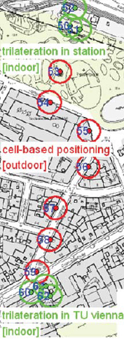
Alternative location methods for absolute positioning in areas where no GNSS position determination is possible due to obstruction of the satellite signals are needed in mobile positioning. Active RFID (Radio Frequency Identification) can be used also for position determination, although the system was not only developed for positioning and tracking but mainly for identification of objects. Using RFID in positioning, different approaches can be distinguished, i.e., cell-based positioning if the RFID tags are installed at active landmarks (i.e., known locations) in the surroundings, trilateration if ranges to the RFID tags are deducted from received signal strength (RSS in RFID terms) values and location fingerprinting where the measured signal power levels are used directly to obtain a position fix. Using Cell of Origin (CoO) the achievable positioning accuracy depends on the size of the cell and is therefore usually several metres up to 10’s of metres using long range RFID equipment. Higher positioning accuracies can be obtained using trilateration and fingerprinting. In this paper the use of trilateration is investigated.


 (5.00 out of 5)