Articles in the Geodesy Category

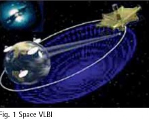
Space Very Long Baseline Interferometry (SVLBI) is an extension of the ground-based VLBI technology to space, which involves a simultaneous observation of the same radio source by two stations; one on the ground, the other being space-based. It could not only overcome the baseline length limitation problem specific to groundbased VLBI technology, with a great improvement on the observation resolution, but could also directly…

Very Long Baseline Interferometry (VLBI) is the unique space
geodetic technique which can provide the Celestial Reference Frame (CRF), the Terrestrial Reference Frame (TRF) and the relationship between the two frames — Earth Orientation Parameters (EOP) at the same time. VLBI has a widely usage in space geodetic, ground
geodetic, geophysical fields and so on. Presently, it can determine the position of the radio source outside the galaxy with 1mas precision, and determine several kilometers length of baseline on the earth’s surface with 1cm precision. Due to its high stability and high precision character, the Celestial Reference Frame outside the galaxy based on VLBI has been the best realization of the quasi-inertial referenceframe since 1980s. VLBI stations are the most important benchmarks in the International Terrestrial Reference Frame (ITRF), and VLBI is one main supporting technique which determines EOP. Till now, space and ground VLBI have accumulated more than 20 years’ data. They provide continuous and long-term data guarantee for space geodetic, ground
geodetic and geographical research.

SVLBI (Space Very Long Baseline Interferometry) is an extension of the ground-based VLBI into the space. It has some important potential applications in geodesy and geodynamics, including the definition, practical realization, and the interconnection of different reference frames, determining the geocentric positions of VLBI stations, estimation of the gravity field of the Earth, and satellite orbit determination using the delay and delay rate observables.

To create no residual global rotation with regards to the crust in time evolution in orientation, IERS in the first ITRF88 retained the BIH Conventional Terrestrial System (CTS) and its Conventional Terrestrial Pole (CTP) 1984.0. Since then, it has realized the same “Pole”. However, IERS changed the name “CTP” to International Reference Pole (IRP).
Historical Start
The Earth’s first Terrestrial Reference Frame (TRF) was called Conventional International Origin (CIO) 1905 where the mean orientation of the Z-axis was defi ned by International Latitude Service from six years of observations between 1900 to 1905 (Note: There is NO other “CIO” ever defi ned). The records are not clear whether ILO ever provided a specifi c defi nition for the X-axis and/or the zero meridian.

In India, for topographical mapping, we are using an old Geodetic Datum (reference ellipsoid on which the coordinates: Latitude and Longitude are projected, and mapping is carried out), called Everest 1880, defined by the work of Col. George Everest (one of the greatest Geodesists, for whom the highest peak in the world is named). It is a local datum, best-fi tting for India (as in 1880), but not fi tting the Earth as a whole in the best possible manner.

The demand for a high resolution geoid model has grown substantially during the last few decades especially after inception of Global Positioning System (GPS). Many countries across the world have already developed their own geoidal model which serve as the means of deriving orthometric heights from GPS observations. The impact of GPS on surveying application is undeniable. More so, this revolution has not been confi ned to the surveying community, but has extended into mapping, navigation and Geographic information system (GIS) areas. During the last few years, we have been witnessing the wide spread adoption of GPS with an equivalently
vibrant range of accuracy requirement. Many of these applications require accurate vertical positions.
The task of transforming the ellipsoidal height obtained from GPS technique to the orthometric height has prompted geodesists around the world to determine the high precision geoid undulations, for their region of interest. In India the present day nation wide geoid was computed a long time back and based on astro geodetic observations with respect to Everest spheroid. It has various limitations and does not have any signifi cance as far as GPS solutions for orthometric height is concerned.

In 1900, the International Latitude Service started to monitor the wobbling and wandering of the North Pole. Since that year, the North Pole has been moving south. In everyday terminology, it has moved secularly on the Earth’s surface in the only direction it knows, i.e., south. The total motion has been about 13.5 meter over the past 100+ years, which in other words amounts to an amazing rate of 13 cm per year or about 1 cm per month…

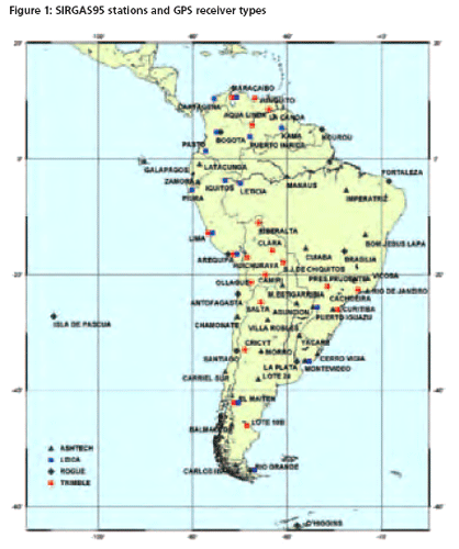
SIRGAS (Sistema de Referencia Geocéntrico para las Américas) is a joint project of South, Central and North American countries in cooperation with some international institutions for the establishment and maintenance of a geocentric reference frame for practical and scientific use. A unique reference frame for the American continent was established by two extremely successful geodetic observation campaigns…

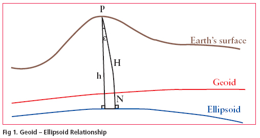
Transformation of GPS derived ellipsoidal height to orthometric height is one of the most important applications of gravimetric geoid. Its applicability remains questionable if the above transformation cannot be done to a reasonable order of accuracy. Use of GPS observations at levelling benchmarks and subsequently determined geoidal seperation using the geometrical relationship between geoid and ellipsoid (see fig. 1 )…


 (5.00 out of 5)