| GIS | |
A hybrid GIS space syntax methodology for prioritizing slums
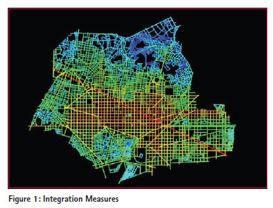
Slums in Egypt – as in many developing countries – are considered as one of the most important problems in Egypt. There are about 1,100 slum areas hosting about 16 million inhabitants. Slums in Egypt vary considerably in their characteristics which make prioritization and intervention policy a debatable issue. This paper highlights the importance of differentiating slum areas for the purpose of governmental intervention according to a certain methodology that takes into account different indicators varying from basic, socio-economic, demographic and morphologic data. The paper proposes a decision-support model using a decision-tree and a hybrid GIS and Space Syntax methodology. The underlying logic for the model is a new approach for assessing the utility of intervention called Coexistent Urbanism. What is Coexistent Urbanism?In dealing with theories of diverse city cultures, fabrics, classes and economic strata, one is faced with a limited number that relate to all four. Environmental determinism, for one, links behavior change with the built environment (Johnson, 1994). Space syntax on the other hand encompasses a set of theories and techniques to analyze spatial configurations of the urban area to associate economic or social performance of city areas by virtue of their street continuity (or discontinuity). Combining these theories to effectively and humanisticly deal with the informal area upgrading has not been tried. Conventional approaches consider slums as an urban disease that needs to be quarantined to avoid an epidemic. Others consider it as cancer cells or pockets within the healthy urban area that needs surgical intervention. Neither approach has proven effective. Coexistent Urbanism is a new proposed approach that deals with informal areas in a different way. Rather than dealing with informal areas locally and through focused intervention, it seeks to gradually assimilate the community with its surrounding urban area socially, economically and physically by integrating its street fabric first until they become totally dissolved within the surrounded urban areas and become a harmonious part of the surrounded urban social and economic structure. In the long run, such assimilation combined with directing growth along a development axis could even be spared from strategic agricultural land. The primary tools used to analyze and diagnose the suitability of urban areas for this approach are Space Syntax and Geographic Information Systems. Space syntax software and GISSpace Syntax software such as Depthmap analyses the spatial configuration of a pattern as a set of axial lines measuring certain indicators such as the integration value and choice. Accessibility between street segments accordingly describes how easily one navigates between streets and where obstructions are. Originally, it was conceived by Bill Hillier, Julienne Hanson and colleagues at The Bartlett, University College London in the late 1970s to early 1980s as a tool to help architects simulate the likely social effects of their designs. Now, it is applied to a wide array of applications such as crime, transportation, military and also informal/civil areas. Primary space syntax measuresIntegration: Is one of the most popular Space Syntax analysis methods of a street network. It measures how many turns one has to make from a street segment to reach all other street segments in the network, using the shortest paths (Figure 1).
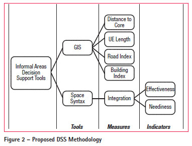
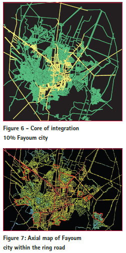
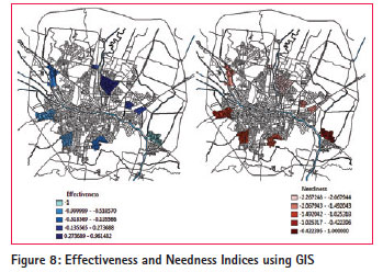
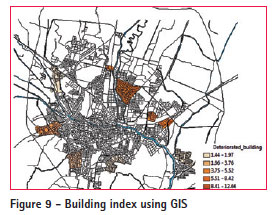
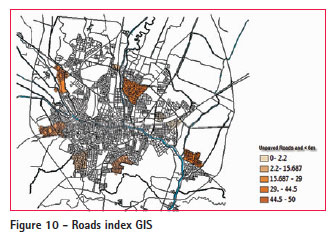
The street segments that require the least amount of turns to reach all other streets are called ‘most integrate’ and are usually represented with warmer colors, such as red or yellow. If an integration radius is identified; it could be in local scale or at a certain radius. One limitation of the Depthmap is that it ignores wide, situation and degree of streets. It does not consider street properties that are not measured by pure physical continuity. Factors such as street width, pavement, condition and vehicular-pedestrian mix are impediments to connectivity but are not included in the analysis. That is why Space Syntax integrated with GIS in a Coexistent Urbanism development approach may be useful to produce a complex index that would contribute to determine the priority of intervention to upgrade a slum area. Depthmap may be used to measure direct integration measures, and on the other hand GIS may be used to get the indices such as Building Index (percentage of deteriorated buildings in each slum), Roads Index (percentage of unpaved and less than 6m wide roads), Urban Edge length (length of slum borders adjacent to the urban edge) and finally, the distance between the centre of gravity of each slum to the centre of gravity of the city, which is located inside the core of integration 10%. MethodologyIn order to differentiate between slums using a comprehensive approach, we propose that one has to consider three groups of factors: basic and socio economic factors, urban analysis factors and fabric morphologic factors. Basic data include conventional indicators such as area, population size, poverty level, unemployment, crime rates, etc. Urban analysis factors present the decision-maker with key spatial information on locations of deteriorated buildings, specific street conditions, distance to core, etc. Morphologic factors include street fabric connectivity and integration. A compounded index is designed and tested for each of these components. The final decision is based on a tree chain of elimination rather than a mathematical equation of quantitative addition. Space Syntax is applied to the slums network with an appropriate buffer to get integration values for each slum. Then, they are classified by a devised normalized index called Coexistence Potential index that measures two critical measures called Effectiveness and Needness for intervention. Effectiveness is achieved by those slums having close proximity to the center of the city and high GIS building and roads indices. Thus, effectiveness is a measure of how well the slum intervention will produce notable impacts to the slum. Needness, on the other hand, considers proximity to the periphery and higher slum growth rate. Thus, it is a measure of how badly the slum requires intervention. In a tree decision structure, it is optional to choose the slum that has the worst socio-economic index or the slum having the longest common borders with the urban edge. The used methodology can be summarized by the chart of intervention (Figure 2).
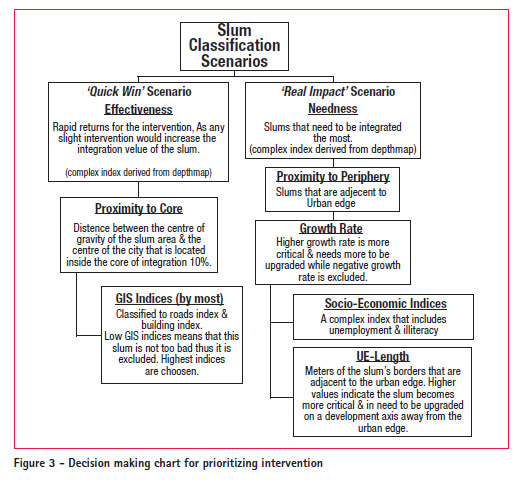
The methodology is applied to the slums of Fayoum city to classify and rank each against the intervention policy depending on a series of complex indices derived from GIS and Space Syntax as shall be shown (Figure 3).
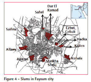
Case Study: Fayoum – the city of 10 slumsFayoum is a city 130 km southwest of Cairo. It contains ten slums classified by the Informal Sector Development Fund (ISDF), hosting nearly about 12% of its total urban area (Figure 4).
Some of these slums were formed over a long period of time; even since before 1800. While others sprawled on the urban edges over agricultural land. The different nature of these slums, their formation nature, their current location within the city, their size and population decomposition, makes comparing them a complicated task without a guiding theory (Table 1).
The guidelines proposed are in tune with the purpose of intervention. Under the policy of coexistent urbanism, a chosen slum area should be selected so that it brings about the fastest and most sustainable path to gradual self-assimilation within the city structure and fabric, so that in a few years one can no longer identify a statistically significant variation within its key indicators. Within the methodology described above, two scenarios are offered to the decision-maker. Both use Depthmap and GIS. Fayoum city street geo-database is analyzed to get the integration values for each of the ten slums (for the whole city and including the ring road).
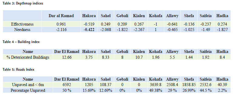
The outcome is then divided into two groups; the first group contains slums that need slight improvement to yield a measurable improvement (quick win), while the second contains slums that are in real bad shape and shall improve considerably by intervention (real need). The following equations were used to compute Effectiveness and Needness.
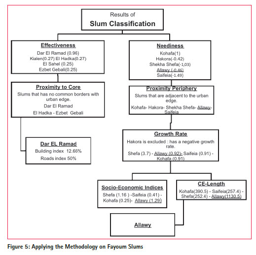
Ei = Ai-Bi +Di-Xi Ni =Xi-Ai-Bi –Di Ai=Integration value for slum (i) roads’ network with surrounding streets. Bi= Integration value for slum (i) roads’ network without surrounding streets. Di= Integration value for surrounding streets only (boundaries of each slum). Xi= Distance from centre of mass of each slum (i) to centre of mass of urban area in Fayoum city (also located in the core of integration 10%). The ‘Quick-Win’ Scenario (Effectiveness) Following the computations of Effectiveness by the previous equation, the second iteration is to choose slums that have close proximity to the core (center of the city). Thus Sahel and Kialen are excluded. In the final round, slums with the highest GIS indices are chosen (BI and RI). The “Real Impact” Scenario (Needness) The other scenario that followed the needness equation yields 5 slums (Hakora- Kohafa- Saifeia- Allawy- Sheika Shefa). All five need to be integrated the most to achieve a real impact from intervention. Needness considers proximity to the periphery and high growth rate as indicators of needness. All five mentioned slums satisfy proximity to the periphery condition, but since Hakora has a decreasing growth rate (-0.8), it is excluded. The length of the common borders of the slums with the urban edge is obtained from GIS and the results are shown in Table 6.
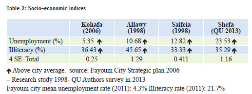
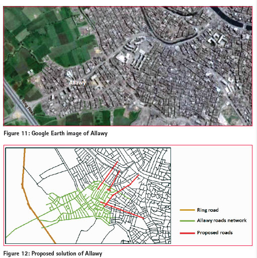
The Needness scenario branches in to two; either choosing slums having the worst socio-economic indicators, or slums having the longest common border with the urban edge (thus presenting threat of expansion over agricultural land). Fortunately, both branches result in Allawy as the slum that achieves the real impact from intervention. ResultsThe proposed Decision Support methodology allows a logical decision-making framework to be followed. Without claiming an optimal decision, it leaves the politician with two clear cut and practical scenarios. One – if he needs a quick-win and the other – if he needs to make a real impact on the ground. This is achieved through passing the 10 slums by a number of filters. Dar El Ramad is the slum that would match the necessary conditions of the quick win scenario. This means that any slight intervention would improve the integration value of its roads’ network. However, using effectiveness only neglects socio-economic indices as it deals with Depthmap and GIS indices only. Once a decision is made for a slum to begin with, the methodology can be tested to verify the utility of intervention. The quickest and simplest test is to begin making physical and road plan modifications to test whether there was a measurable impact of integration. Allawy is a critical slum located adjacent to the city’s urban edge with the borders extending 1,130 m representing nearly about 52% out of its total perimeter. The borders include several agricultural pockets and extend south-west along a road linking the city to the ring road. Thus, Allawy sprawl direction is detrimental to the future of fertile agricultural land. One way of thinking of upgrading Allawy’s future plans should be regarded through integrating roads with the surrounding urban areas and towards the center of the city and away from the agricultural land (Figure 12). Integrating Allawy with the surrounding urban area should be in the north and the east direction. Roads added in the northeast direction have high integration values (0.935 and 0.933). Making these simple modifications would improve the average value of the whole network, as well as improving the east borders of Allawy. The integration value of these eastern roads will increase from 0.79 to 0.90, and improving a road in the east and extending it will change its integration value from 0.692 to 0.919. These modifications together increased the integration value of the whole network of Allawy from 0.78 to 0.8. Although a slight change, it shows how closely selected minor modifications could change the integration value by more intervention. ConclusionThis study has shown that prioritizing intervention on the local level should be clearly supported by a declared political vision as well as a scientific methodology that takes in to account different factors and indices. This methodology proposed follows a theoretical approach called coexistent urbanism in which the chosen slum area would be selected according There is also a need to reclassify slums in Egypt and to reconsider their factors of classification. It was noticed that some slums according to official classification are so well urbanized areas and their indices are not too bad. On the other hand, this classification ignored many degraded Figure 11:Google Earth image of Allawy Figure 12: Proposed solution of Allawy areas that need to be mentioned as slums in order to again stakeholders’ attention. ReferencesHillier, Bill (1996) Space is the Machine. Press Syndicate of the University of Cambridge. Hillier, Bill and Hanson, Julienne (1984) The Social Logic of Space. Cambridge University Press. Satterthwaite, David and Bicknell, Jane (1989) Environment and Urbanization. SAGE Publications GTZ (2009).Cairo’s Informal Areas between Urban Challenges and Hidden Potentials Johnson, Paul (1994). The Theory of Architecture: Concepts, Themes, and Practices. The paper was presented at The Eighth National GIS Symposium in Saudi Arabia during 15-17 April 2013. |






 (7 votes, average: 3.29 out of 5)


Leave your response!